Beautiful, Warm Easter Sunday
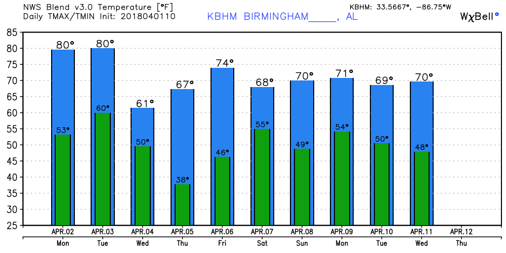
Our satellite view on this Easter morning showed a thin streak of high cirrus clouds from near Columbus, MS, to just west of Troy, AL, with the bulk of Alabama under a clear sky. We should see temperatures warm up from the current values in the middle 40s into the upper 70s.
Monday remains dry with weak ridging aloft across the eastern two-thirds of the country as our highs approach the 80-degree mark for the sixth time in 2018. But the trough developing over the Northwest US moves rapidly to eastern Nebraska by midday on Tuesday with the surface low moving from just north of Kansas City to the vicinity of Chicago on Tuesday. This will bring a cold front into the Lower Mississippi River Valley at midday on Tuesday with the potential for severe weather outlined by SP from East Texas across portions of Arkansas and Louisiana into West Tennessee.

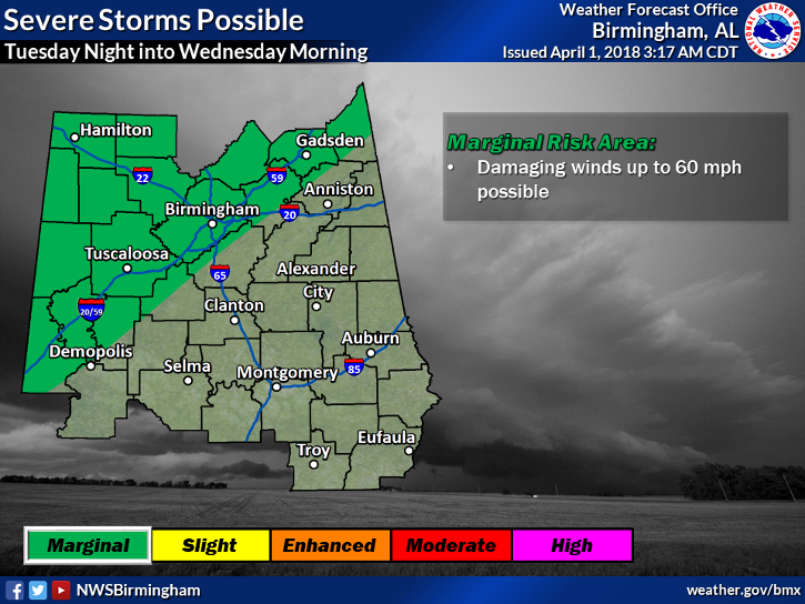
The severe weather threat for Alabama, while not zero, appears to be marginal for the area generally along and northwest of the Interstate 20 corridor as seen in the graphic below from the NWS in Birmingham. Damaging straight-line wind appears to be the biggest concern.
The upper trough zips into the eastern Great Lakes region on Wednesday, so the threat of rain or thunderstorms is once again swept east of Alabama. But Wednesday could be one of those somewhat raw days with the temperatures remaining in the 50s or possibly falling through the middle and lower 50s during the afternoon and evening.
Northwesterly flow aloft dominates the upper air chart on Thursday. With a surface high projected to settle into the Southeast US, Thursday morning will be rather chilly. The GFS MOS guidance table prints out a 37 degree low for Birmingham. This means that there is a reasonably good chance we could see some patchy frost especially from just south of Birmingham northward. With a mostly sunny day, the afternoon highs should warm nicely into the upper 60s.
A weak upper air disturbance over Nebraska on Friday moves to near Memphis on Saturday ramping up rain chances for Saturday. It’s interesting to note that the GFS is faster and wetter than the ECMWF forecast, so model differences lower the confidence in rain for Saturday morning. But both models move the upper disturbance and the surface low by fairly quickly bringing some hope to a dry second half to next weekend. The potential for severe weather with this system seems to remain along the Gulf Coast, but we will need to keep an eye on future model runs to see how it develops.
Looking out into voodoo country, a strong upper trough goes by well to our north on the 9th of April as we come under a strong ridge around the 11th. The ridge pattern remains in place through the 13th with a strong trough forecast to move across the Central US around the 15th of April. So the pattern remains fairly active and warm.
Beach Forecast: Click here to see the AlabamaWx Beach Forecast Center page.
WeatherBrains: Don’t forget you can listen to our weekly 90 minute netcast anytime on the web, or on iTunes. This is the show all about weather featuring many familiar voices, including our meteorologists here at ABC 33/40.
I’ll be filling in for Charles Daniel this weekend, so you can catch the latest forecast with ABC 3340 News at 5 and 10 pm this evening. James Spann will have the next Weather Xtreme Video on Monday morning. Have a great day and Godspeed.
-Brian-
.
Category: Alabama's Weather, ALL POSTS, Weather Xtreme Videos
About the Author (Author Profile)
Brian Peters is one of the television meteorologists at ABC3340 in Birmingham and a retired NWS Warning Coordination Meteorologist. He handles the weekend Weather Xtreme Videos and forecast discussion and is the Webmaster for the popular WeatherBrains podcast.Subscribe
If you enjoyed this article, subscribe to receive more just like it.


