6:30 PM Check On Our Weather; Storms Only A Couple Of Hours Away From Alabama
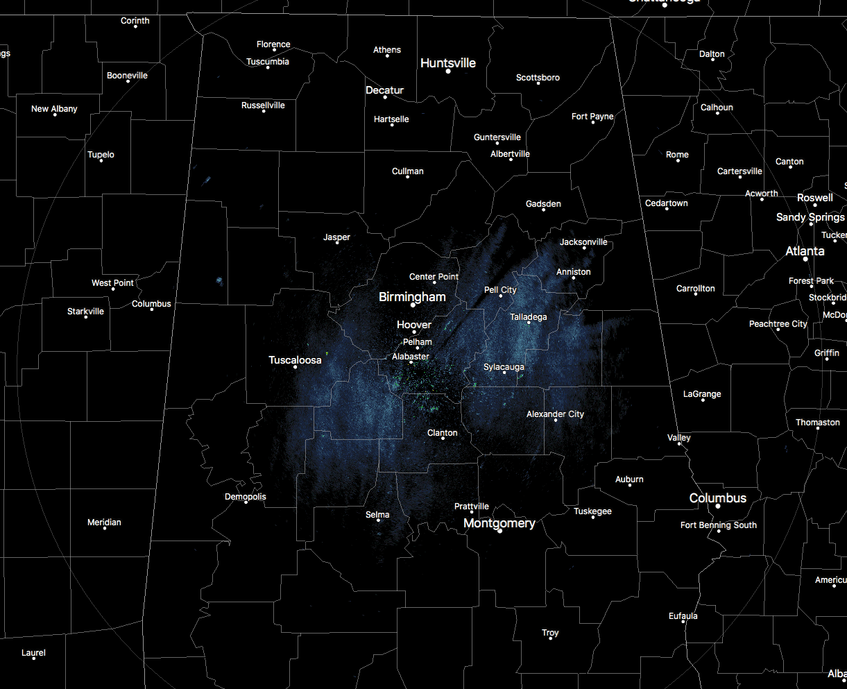
Radar check at 6:30 PM is showing dry conditions across North/Central Alabama on this beautiful Tuesday evening, but that will be sure to change within the next 90 to 120 minutes. A few places are showing on radar at the moment, but those are not making it to the surface at this time. Temperatures are still running in the upper 70s to the lower 80s throughout the area from north to south, and most places have a decent supply of sunshine before the sun sets.
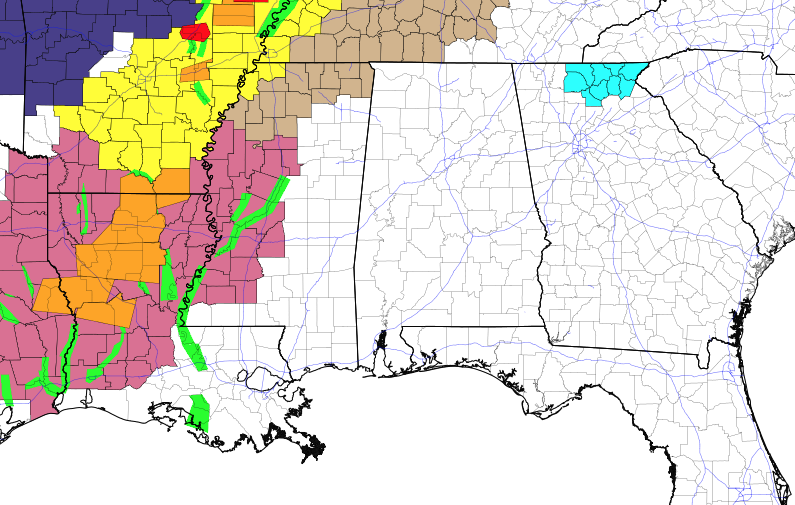
As you can see by the above current hazards map as of 6:20 PM is showing the action has really picked up to our west. A Severe Thunderstorm Watch (pale violet-red) is in effect for the east and southeastern parts of Mississippi, and back into much of western Louisiana and southern Arkansas. A Tornado Watch (yellow) is in effect for extreme northwestern parts of Mississippi, extreme western Tennessee, and east and central Arkansas. Several Severe Thunderstorm Warnings and a couple of Tornado Warnings were in effect at the time as well.
We’ll have to see what the Storm Prediction Center has in store for North/Central Alabama later this evening. I’m pretty confident that we’ll have a watch or two, and I wouldn’t be surprised if the northwestern parts of the state in the Enhanced Risk will be in a Tornado Watch, while the Slight Risk areas will have a Severe Thunderstorm Watch.
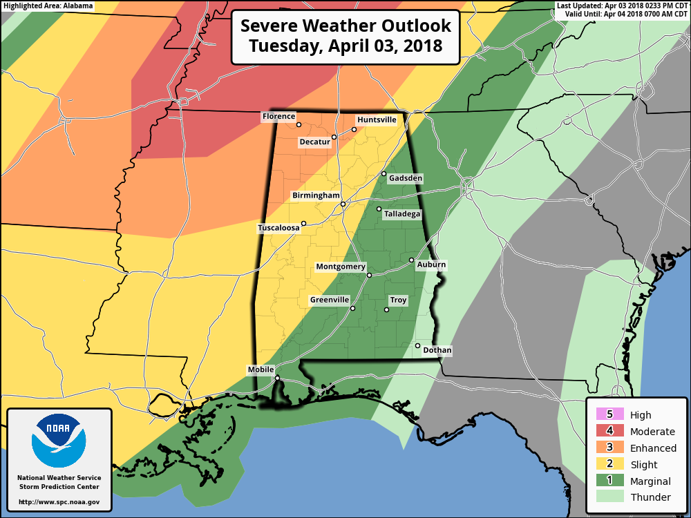
The SPC has an Enhanced Risk of severe storms defined for locations west of a line from Hytop (Jackson Co). to Arley (Winston Co.) to just west of Reform (Pickens Co.). A Slight Risk continues for areas east and southeast of that, stretching to a line from Sand Rock (Cherokee Co.) to Pell City (St. Clair Co.) to Clanton (Chilton Co.) to just east of Selma (Dallas Co.). The rest of Central Alabama east of the slight risk has been defined in a Marginal Risk for severe storms with the exception of the extreme southeastern corner of the area.
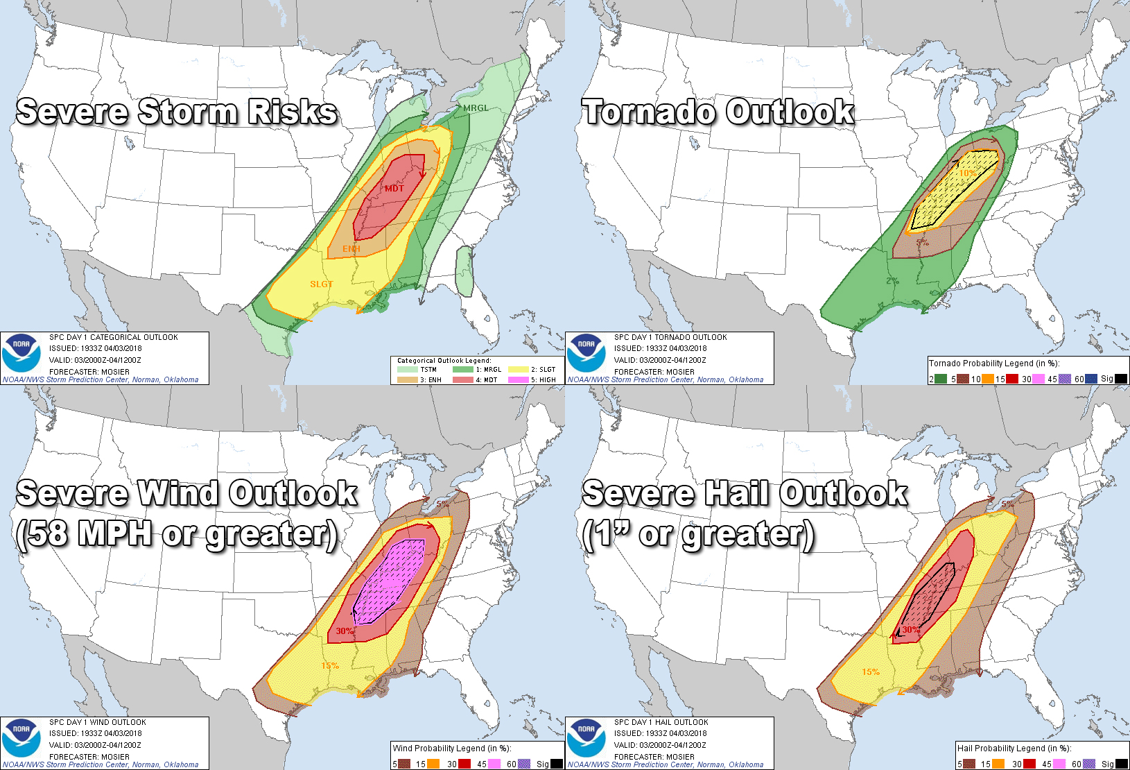
Here are the risk level for each possible threat we can see tonight and into the early morning hours on Wednesday. As you can see, this is going to be more of a damaging wind event than a tornado threat across North and Central Alabama. The higher risks for damaging winds, hail of 1″ diameter, and a few tornadoes will be located in the areas defined in the Enhanced Risk for severe storms.
The risk for all three threats drop as you move into the Slight Risk areas due to the air becoming a little more stable and the strength of the line diminishing. At that point, it will still have the threat for damaging winds, but the threats for 1″ hail and tornadoes will be much less. Even with that said, expect the unexpected with severe thunderstorms in Alabama during this time of the year.
There still will be a very small risk of 1″ hail and damaging winds as the line moves into the locations defined in the Marginal Risk, but the tornado risk will virtually be done. A weak spin-up is possible, but highly unlikely, so continue to stay ready for action until the all clear is given.

21z HRRR Composite Reflectivity simulated radar valid from 4:15 PM today to 10:00 AM Wednesday.
Timing for strong to severe storms to affect the Enhanced Risk areas (west of a line from Hytop (Jackson Co). to Arley (Winston Co.) to just west of Reform (Pickens Co.) will roughly be from 8:00 PM to 1:00 AM.
Timing for strong to severe storms to affect the Slight Risk areas (west of a line from Sand Rock in Cherokee Co. to Pell City in St. Clair Co. to Clanton in Chilton Co. to just east of Selma in Dallas Co.) will roughly be from 11:00 PM to 4:00 AM.
Timing for strong to marginally severe storms to affect the Marginal Risk areas (the east and southeastern parts of North/Central Alabama) will roughly be from 2:00 AM to 6:00 AM.
By the time we reach 7:00 AM Wednesday morning, all of the stronger storms will have pushed out of North/Central Alabama. We may have to deal with the showers on the backside of the line especially in the south and southeastern parts of the area, but those will be out of the way by the early afternoon.
Category: Alabama's Weather, ALL POSTS
About the Author (Author Profile)
Scott Martin is an operational meteorologist, professional graphic artist, musician, husband, and father. Not only is Scott a member of the National Weather Association, but he is also the Central Alabama Chapter of the NWA president. Scott is also the co-founder of Racecast Weather, which provides forecasts for many racing series across the USA. He also supplies forecasts for the BassMaster Elite Series events including the BassMaster Classic.Subscribe
If you enjoyed this article, subscribe to receive more just like it.


