Strong/Severe Storms Arrive Late Tonight; Colder Tomorrow
WINDY, WARM AFTERNOON: Temperatures have reached the low 80s in many areas across Alabama this afternoon with a mix of sun and clouds; we have a strong south wind of 15-25 mph with higher gusts. Nothing on radar, but tornado watches are in effect for much of Arkansas and parts of West Tennessee, ahead of a cold front that will bring storms to our state late tonight.
STORMY NIGHT: We now have an “enhanced risk” of severe storms over Northwest Alabama tonight, west of a line from Huntsville to Carbon Hill to Fayette to Reform. The standard “slight risk” extends down to Gadsden, Clanton, Camden, and Citronelle. And, a “marginal risk” is defined as far east as Opelika and Geneva.
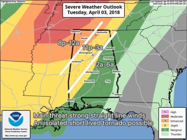
TIMING: The line of severe storms should enter the northwest corner of Alabama sometime between 8:00 and 10:00 p.m… then reaching Birmingham/Tuscaloosa/Gadsden around midnight to 1:00 a.m… Anniston by 2:00 a.m…. and Montgomery by 4:00 a.m. The storms will be weakening as they move south and east of Birmingham, moving into a more stable atmosphere during the pre-dawn hours.
THREATS: The main threat tonight will come from strong, potentially damaging straight line winds… enough to knock down trees and power lines. A few isolated, brief tornadoes are possible, along with some hail.
RAIN AMOUNTS: Rain totals of 1/2 to 3/4″ are expected for most communities, not enough for any serious flooding issues.
Be sure you have a good way of getting severe weather warnings if they are needed late tonight!
Tomorrow will be windy and much cooler; the sky becomes sunny with a high only in the 60-65 degree range. A gusty north wind will make it feel cooler.
FROST THREAT EARLY THURSDAY: The winds will die down tomorrow night, and with a clear sky the stage is set for widespread frost over the northern half of Alabama early Thursday morning. Most communities will see a low in the mid 30s, but the traditionally colder spots will see a low at or below freezing. Then, during the day Thursday, we will enjoy a sunny sky with a high in the upper 60s.
FRIDAY AND THE WEEKEND: It now looks like Friday will be a dry day; the sky will be partly sunny with a high in the mid 70s. Then, clouds increase Friday night, and Saturday will be much cooler and wet with periods of rain. A good chance we hold in the 50s all day Saturday as a surface front drifts down into South Alabama… it won’t rain all day, but occasional rain is likely.
The sky will clear Saturday night, and it now looks like we will have another threat of frost early Sunday morning with mid 30s, and a freeze for colder spots. Sunday looks dry at this point with a mix of sun and clouds; the high will be close to 70 degrees. Clouds return Sunday night, and some rain could reach Alabama after midnight.
NEXT WEEK: Rain and a few storms are likely Monday with a cold front passing through, Tuesday will be much cooler with a clearing sky, and yet another late season frost threat is ahead by early Wednesday morning. See the Weather Xtreme video for maps, graphics, and more details.

BEACH FORECAST: Click here to see the AlabamaWx Beach Forecast Center page.
WEATHER BRAINS: Don’t forget you can listen to our weekly 90 minute netcast anytime on the web, or on iTunes. This is the show all about weather featuring many familiar voices, including our meteorologists here at ABC 33/40.
CONNECT: You can find me on all of the major social networks…
Facebook
Twitter
Google Plus
Instagram
Pinterest
Snapchat: spannwx
I enjoyed seeing the students today at American Christian Academy in Tuscaloosa… and North Jefferson Middle School in Kimberly. Be looking for them on the Pepsi KIDCAM today at 5:00 and 6:00 on ABC 33/40 News! The next Weather Xtreme video will be posted here by 7:00 a.m. tomorrow…
Category: Alabama's Weather, ALL POSTS, Weather Xtreme Videos
About the Author (Author Profile)
James Spann is one of the most recognized and trusted television meteorologists in the industry. He holds the AMS CCM designation and television seals from the AMS and NWA. He is a past winner of the Broadcast Meteorologist of the Year from both professional organizations.Subscribe
If you enjoyed this article, subscribe to receive more just like it.


