Tornado Watch Issued To Our West
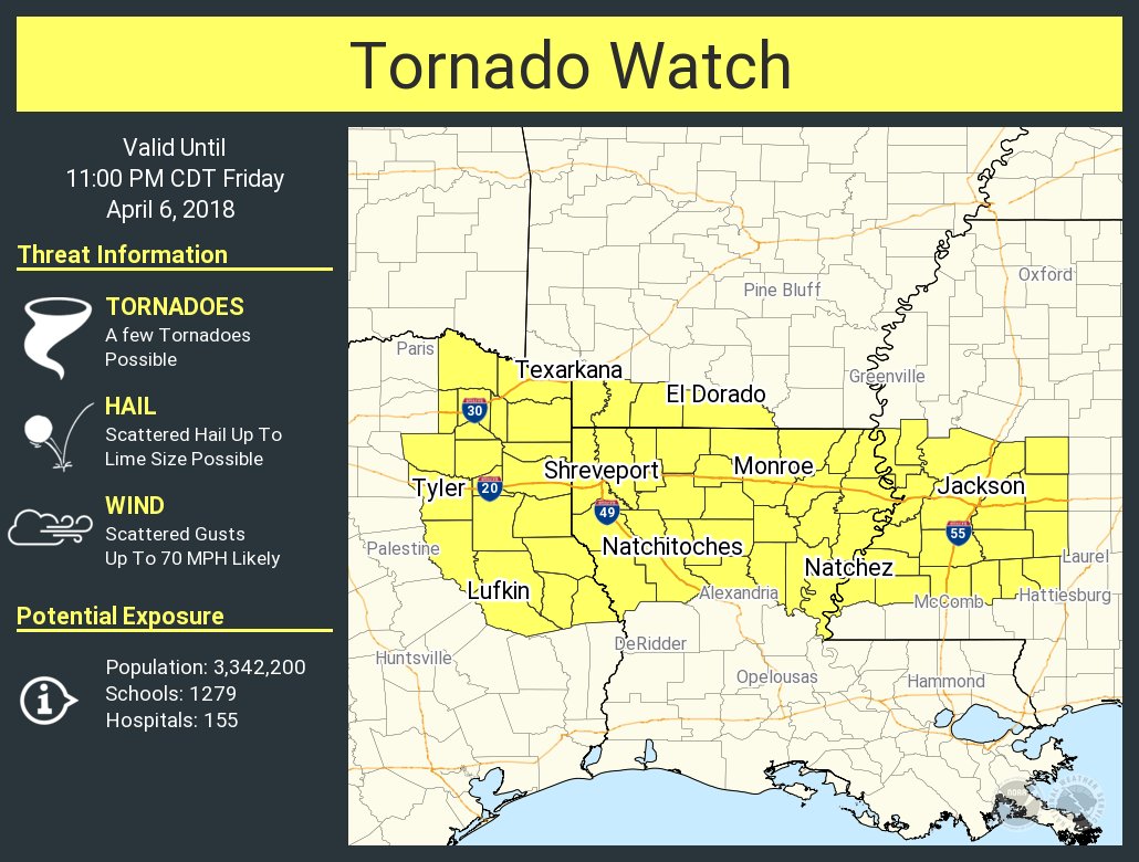
The Storm Prediction Center has issued a Tornado Watch for southwestern Arkansas, northern Louisiana, northeast Texas, and west/central Mississippi effective immediately until 11:00 PM tonight. The watch includes the larger cities of Tyler, Texarkana and Lufkin Texas, Shreveport and Monroe Louisiana, and Natchez and Jackson Mississippi.
Primary threats in this watch area include a few tornadoes, isolated large hail, and damaging wind gusts up to 70 MPH.
Thunderstorms will increase in coverage/intensity from northeast Texas across northern Louisiana to western and central Mississippi through the remainder of this afternoon and evening. A few supercells will be possible initially, with the threat for a couple of tornadoes and large hail. Gradual upscale growth into more of a squall line is expected by later this evening, with an increasing threat for damaging winds, and an isolated tornado or two will also be possible with circulations embedded in the line.
As this system continues its eastward push, the threats will start to fade after sunset, and only the southwestern and a few location in the southern parts of Central Alabama will be in a Marginal Risk for severe storms during the late night and into the pre-dawn hours on Saturday. We’ll keep you posted throughout the evening on the blog.
Category: ALL POSTS
About the Author (Author Profile)
Scott Martin is an operational meteorologist, professional graphic artist, musician, husband, and father. Not only is Scott a member of the National Weather Association, but he is also the Central Alabama Chapter of the NWA president. Scott is also the co-founder of Racecast Weather, which provides forecasts for many racing series across the USA. He also supplies forecasts for the BassMaster Elite Series events including the BassMaster Classic.Subscribe
If you enjoyed this article, subscribe to receive more just like it.


