

At 2:00 AM, Storms Continue To Move Across The Southern Parts Of Central Alabama
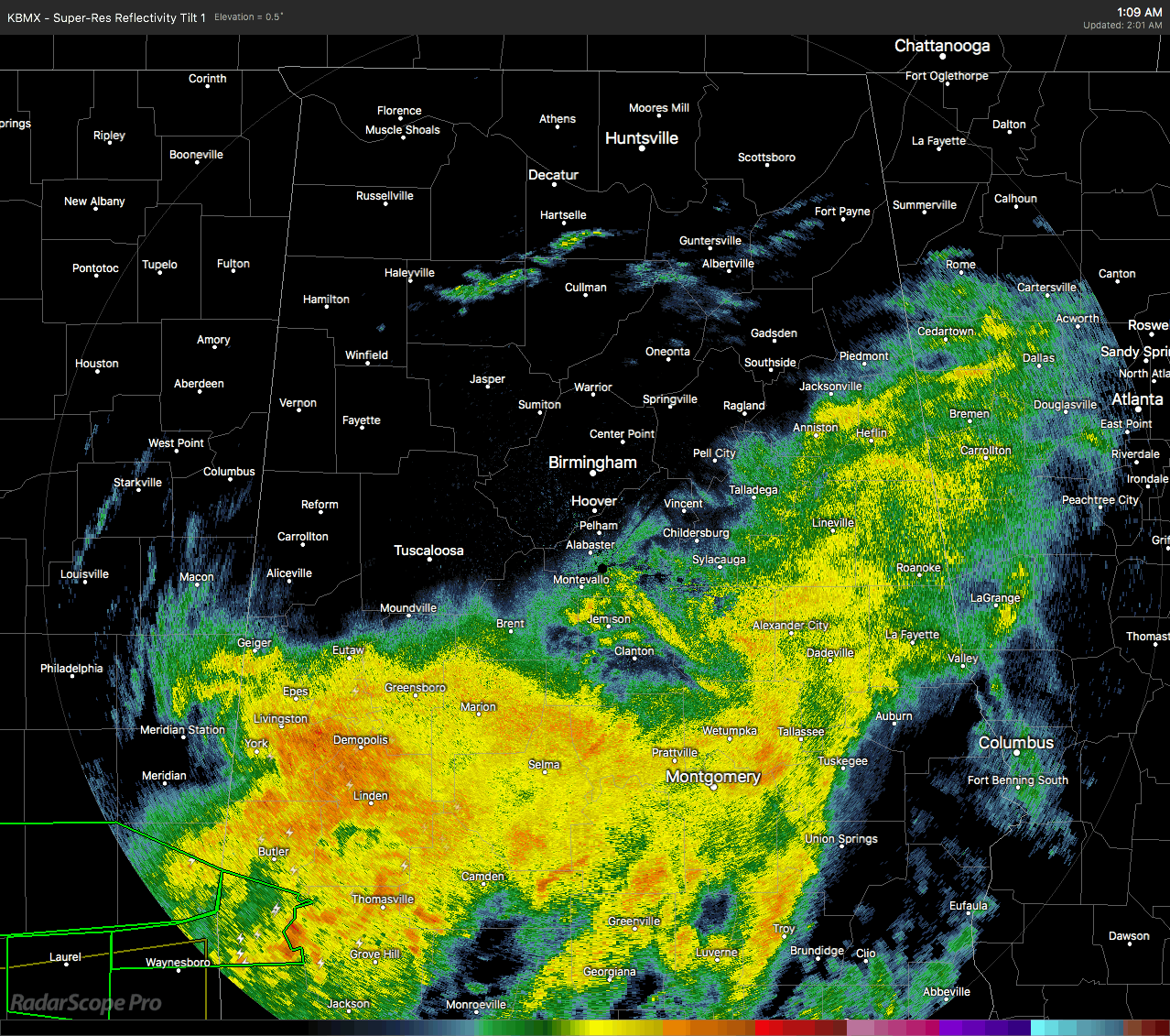
As we make the approach to the 2:00 AM hour in Central Alabama, just about all of the rain and thunderstorm activity has pushed south of I-20 and I-20/59. We have gone through the night so far without a single warning being issued, and there is a decent chance that may be the story throughout the remainder of the pre-dawn hours.
All surface-based instability continues to hug the Florida state line in the extreme southern parts of the state and down to the Gulf Coast, with virtually none in Central Alabama. Dewpoints have crept up a little bit since the last update, mainly in the 50s throughout much of the area, but moisture has increased in the southern parts of the area into the lower 60s from Selma to Montgomery to Troy and Eufaula. The greatest low-level helicity values are back in the southwestern parts of the area, but dewpoints have dropped back below 60 degrees so organized severe storms will be unlikely.
Latest NAM-3k model run shows that instability values will slowly rise in the southeastern parts of the area throughout the remainder of the pre-dawn hours, along with helicity values that will be just high enough to support rotating updrafts. So, we’ll have to continue to keep our eye on the weather situation through daybreak as isolated damaging wind gusts are still a threat, with an isolated brief tornado being a much lower threat.
We still have about 2 hours more for a threat of severe weather to occur west of a line from Wetumpka to Fort Deposit, while the Marginal Risk for severe storms continues from now until at least 7:00 AM east of that same line. There is no risk for severe weather north of a line from Geiger to Wetumpka to Fort Mitchell.
In case you are wondering where the cold front is currently located, it is currently draped over central Tennessee down through the northwestern corner of Mississippi and down into central Arkansas. That front will make its way into the northwest corner of the state within the next 60-90 minutes.
Category: Alabama's Weather, ALL POSTS
About the Author (Author Profile)
Scott Martin is an operational meteorologist, professional graphic artist, musician, husband, and father. Not only is Scott a member of the National Weather Association, but he is also the Central Alabama Chapter of the NWA president. Scott is also the co-founder of Racecast Weather, which provides forecasts for many racing series across the USA. He also supplies forecasts for the BassMaster Elite Series events including the BassMaster Classic.Subscribe
If you enjoyed this article, subscribe to receive more just like it.


