Parts Of North/Central Alabama Under A Flash Flood Watch On Saturday
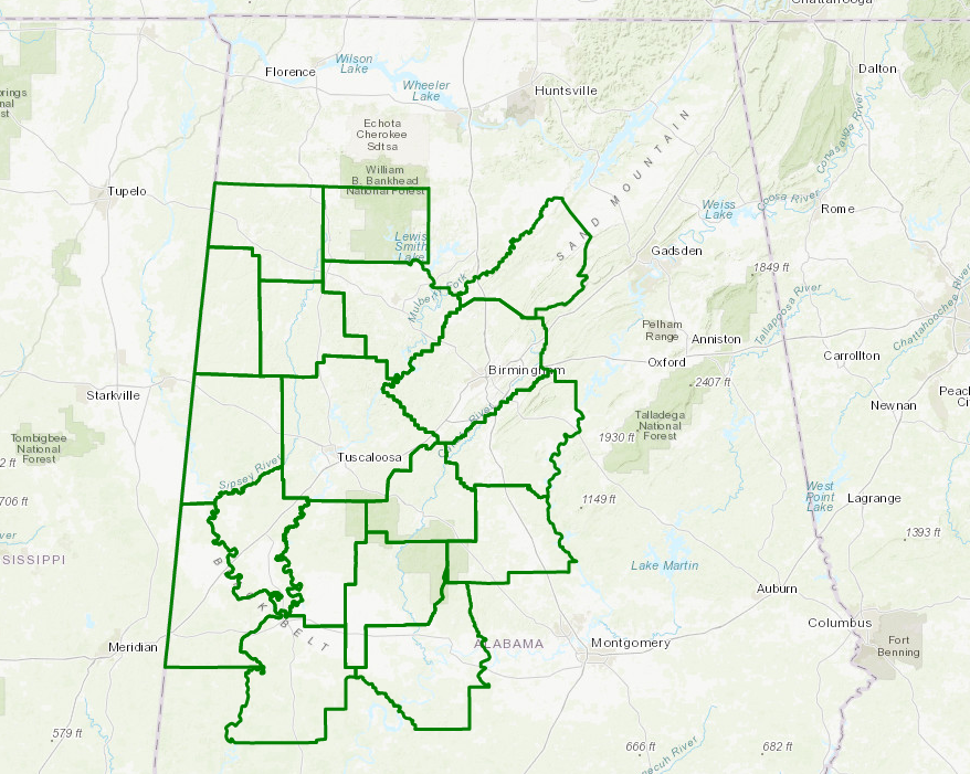
Heavy Rainfall May Cause Flooding Across West Central Alabama
A line of thunderstorms moving through Central Alabama on Saturday is forecast to result in several inches of rainfall. This could result in flooding of poor drainage and low lying areas, as well as rises on rivers and creeks.
Therefore, the National Weather Service in Birmingham has issued a Flash Flood Watch for portions of central Alabama, generally along and west of a line from Oneonta to Clanton to Selma from Saturday morning through late Saturday night.
Rainfall totals of three to four inches could result in flooding of poor drainage and low lying areas, as well as rises along rivers and creeks.
Counties in watch include: Bibb, Blount, Chilton, Dallas, Fayette, Greene, Hale, Jefferson, Lamar, Marengo, Marion, Perry, Pickens, Shelby, Sumter, Tuscaloosa, Walker, Winston.
A Flash Flood Watch means that conditions may develop that lead to flash flooding. Flash flooding is a very dangerous situation. You should monitor later forecasts and be prepared to take action should Flash Flood Warnings be issued.
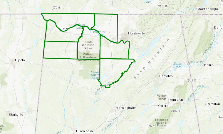
A Flash Flood Watch is in effect for portions of northwest and north central Alabama Saturday and Saturday evening
Multiple rounds of moderate to heavy showers and thunderstorms are possible along and ahead of an approaching cold front across much of north central and northwest Alabama Saturday into Saturday evening. Total rainfall amounts around 3 to 4 inches, with locally higher amounts, possible across the watch area. The threat for heavy rain and thunderstorms will then diminish from west to east after Midnight Sunday, as the front begins to move across the Tennessee Valley region.
Therefore, the National Weather Service in Huntsville has issued a Flash Flood Watch for portions of north central Alabama and northwest Alabama, including Cullman, Limestone, Morgan, Colbert, Franklin, Lauderdale, and Lawrence counties, from 7 AM Saturday morning through 1 AM Sunday.
Multiple rounds of moderate to heavy rainfall and thunderstorms may result in excessive rainfall amounts around 3 to 4 inches, with locally higher amounts. Urban areas, lowlands adjacent to rivers and streams, and low water crossings will be the most vulnerable to the excessive rainfall and possible flooding.
A Flash Flood Watch means that conditions may develop that lead to flash flooding. Flash flooding is a VERY DANGEROUS SITUATION. You should monitor later forecasts and be prepared to take action should Flash Flood Warnings be issued.
Category: Alabama's Weather, ALL POSTS
About the Author (Author Profile)
Scott Martin is an operational meteorologist, professional graphic artist, musician, husband, and father. Not only is Scott a member of the National Weather Association, but he is also the Central Alabama Chapter of the NWA president. Scott is also the co-founder of Racecast Weather, which provides forecasts for many racing series across the USA. He also supplies forecasts for the BassMaster Elite Series events including the BassMaster Classic.Subscribe
If you enjoyed this article, subscribe to receive more just like it.


