No Severe Weather Overnight in Alabama; An Update on Saturday’s Threat
By Bill Murray and Scott Martin
After a beautiful day across North and Central Alabama with lots of sunshine, highs mainly in the lower 80s relatively low humidities and a breezy southerly wind, a nice evening is in progress across the area. Clouds are beginning to overspread the western part of the state. Temperatures are cooler in the east where there no fewer clouds, mainly in the upper 0s to middle 60s. 70s are still common in the west.
Severe weather has been occurring since mid-afternoon in areas to the northwest and west of Alabama, and there is a threat of severe weather on Saturday across the entire state of Alabama, including en enhanced (level 3 of 5) threat over the western half of Alabama.
BUT THERE IS NO THREAT OF SEVERE WEATHER OVERNIGHT TONIGHT IN ALABAMA. So rest easy tonight. The window for severe weather on Saturday across Central Alabama is 11 a.m. and 11 p.m. in western counties, between 4 p.m. and 4 a.m. in the I-65 Corridor and mainly after 8 p.m. in the east, lasting until 4 a.m. there.
The main threat is over areas west of I-65 as it appears for now that the main squall line will be weakening as it pushes east of I-65. But that is not certain at this time. There is a significant probability of damaging winds and tornadoes in the enhanced risk area over the western half of the state, including the threat of a few larger tornadoes across West Central Alabama.
The closest storms are some 280 miles west-southwest of Birmingham just after 10 p.m. a severe thunderstorm warning continues for parishes just west of the Mississippi River east of Bastrop LA. This storm had a confirmed tornado in it just a short while ago.
Tornado watches cover northeastern Texas, northern Louisiana, western Mississippi, much of Arkansas, southeastern Missouri all the way into Illinois. There is one tornado warning northeast of Little Rock and one in southern Missouri. There has been a general weakening trend over the past couple of hours, except over northeastern Texas where a squall line does appear to be intensifying. This trend is picked up by the models, showing the line of storms intensifying over the next few hours in response to the forcing of a strong cold front and an intensifying low-level jet.

HRRR model simulated radar at 2 p.m. Saturday
These storms will be approaching the Mississippi River by 3 – 5 a.m. in the morning. They will weaken with time early in the morning, and be approaching northwestern Alabama between 10 a.m. and 2 p.m. depending on the model you like. Here is an assessment of our two main mesoscale models:
HRRR: Storms begin to move into the northwestern parts of the state around 10 AM. At that time we’ll have modest CAPE values up to 1,200 J/kg closest to the squall line. Low-level Helicity values will range from 100-400 m2s2. STP values will only be around 1.0 and less.
NAM-3k: Storms begin to move into the northwestern parts of the state around 2 PM. At that time we’ll have modest CAPE values up to 2,000 J/kg closest to the squall line. Low-level Helicity values will range from 150-320 m2s2. STP values will be around 2.0 and less. Those numbers will climb for a few hours out ahead of the main squall line mainly over the southwestern counties as it moves eastward.
The storms will move slowly east during the late morning and early afternoon, intensifying over eastern Mississippi and western Alabama, especially between 1-4 p.m.
By 7 PM, helicity values drop little over the northwestern parts of the area, along with the STP values. CAPE values will stay elevated up to 1,200 J/kg in the northwest to near 2,000 J/kg in the southwest.
By the time the squall line makes it into the I-65 corridor around 9-11 PM, it will have weakened some and that trend should continue throughout the remainder of the night and into the early morning hours on Sunday. CAPE will be 1,000 J/kg and less, STP values will be less than 1.0 for much of the area, but helicity values will be in the 160-360 m2s2 range.
By 2 AM, the line will have progressed into the Gadsden/Anniston areas along with the rest of the eastern parts of the area. STP values will be less than 0.5 at that point, CAPE values continue to fall toi 600 J/kg and less, and helicity values drop to 160 m2s2 and less. The risk for strong to severe storms should have either diminished or exited the state by 4 AM.
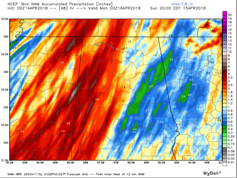
Rainfall totals off the 3 km NAM model through Sunday evening
Rainfall amounts look like they will be significant for areas along and west of I-65, with 2-4 inches possible. Rainfall amounts will tend to be heaviest in the West. A flash flood watch is in effect for much of the western half of Alabama. The rainfall is much appreciated. Unfortunately, the eastern half of Alabama is much drier than the west, but it appears the eastern parts of the state will get less rainfall, less than one inch.
Sunday will be a raw, cool day with rain slowly ending from the west. Rain should end in Birmingham by 7-9 a.m., and temperatures will be falling quickly back into the 40s. They will only recover briefly into the lower 50s during the early afternoon from I-20 to the south. Winds will be brisk, averaging 10-20 mph, gusting to 20-25 mph at times.
Sunday night lows will be near 40F around I-20, with 30s to the north and lower and middle 40s to the south. Monday will be cool, with highs struggling to get out of the 50s. Monday night lows will be in the 30s along and north of I-20, with lower 40s to the south. There is some chance of frost Tuesday morning, especially in areas near and north of Birmingham. Growers should continue to monitor.
Category: Alabama's Weather, ALL POSTS
About the Author (Author Profile)
Bill Murray is the President of The Weather Factory. He is the site's official weather historian and a weekend forecaster. He also anchors the site's severe weather coverage. Bill Murray is the proud holder of National Weather Association Digital Seal #0001 @wxhistorianSubscribe
If you enjoyed this article, subscribe to receive more just like it.


