Stormy Today, Cooler First of Week
Writing the blog discussion is always difficult when the weather is nearly right on top of you since everything is changing so rapidly. A very strong line of thunderstorms with numerous reports of hail, damaging wind, and tornadoes continued to make slow but steady progress across Mississippi this morning. SPC has the western half of Alabama in enhanced risk for severe weather today.

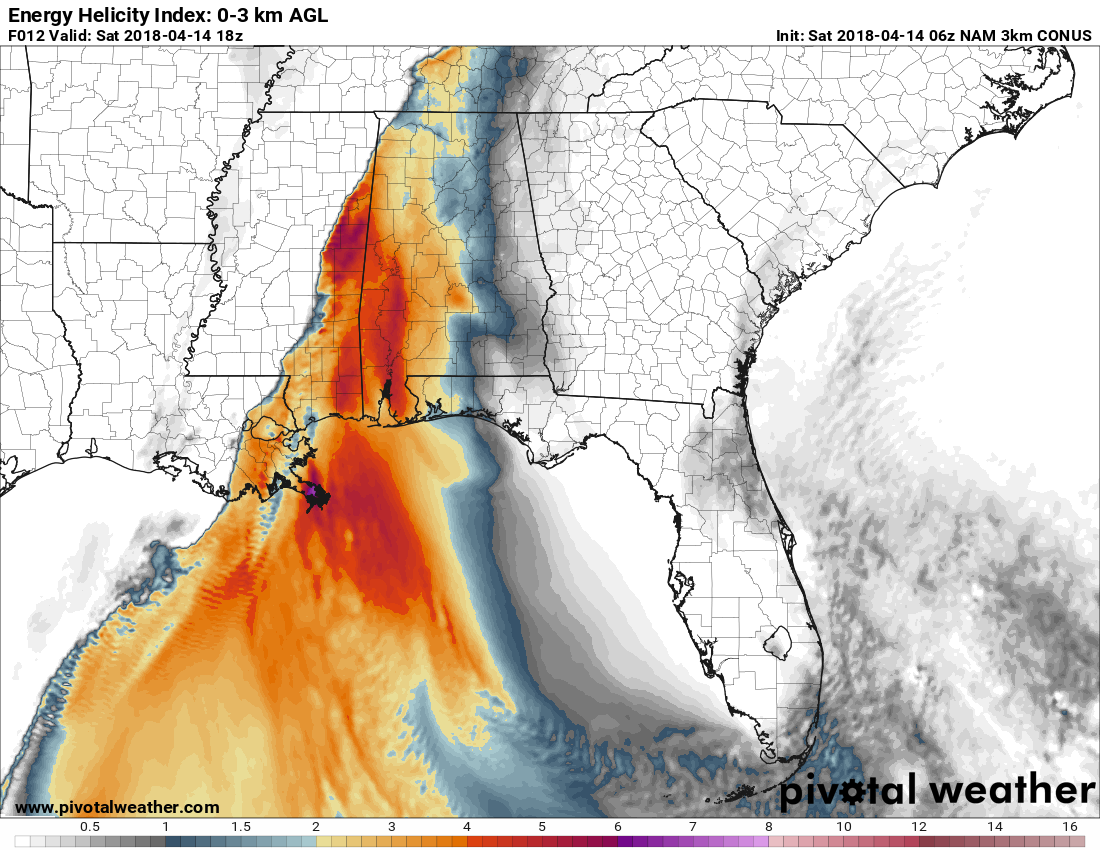
The line of storms stretched from North Central Mississippi southwestward into Southwest Louisiana. The closed low aloft with the upper trough was located over Northeast Kansas (based on projection from last night) and will continue to move east-northeast into Illinois by midday Sunday. EHI values slowly come down as the line moves eastward across Alabama later today and into tonight, so it appears the greatest threat for severe storms will come in the time period from roughly around 10 am through early Sunday morning. A flash flood watch is also in effect for the western two thirds of Alabama with rainfall amounts of 3 to 4 inches expected during the next 18 to 24 hours. Tornado watches were in effect from the northeast corner of Mississippi into Southwest Louisiana.
With the greatest instability forecast across West Central Alabama this afternoon, the potential exists for a couple of tornadoes that could be strong in the EF2 or EF3 category.
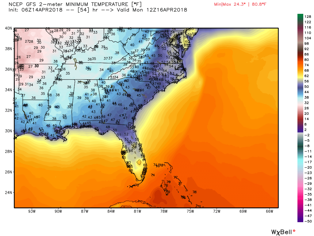
The closed low reaches the eastern Great Lakes by midday on Monday which puts the Southeast US in a good northwesterly flow regime along with good northerly flow at the surface around the surface low there, too. This could produce a rather cold Monday morning with the potential for lows to once again reach into the upper 30s. This is likely to produce patchy frost as those normally colder locations reach near freezing across the northern third of Alabama. While ridging begins to take hold on Tuesday, it could be another rather chilly morning with the risk for patchy frost once again.
A strong upper closed low will move across the northern tier of the US on Wednesday. This is likely to drag a front across the Southeast US on Wednesday. The GFS is suggesting a narrow band of very light precipitation, however, I think the atmosphere will be somewhat moisture starved, so I don’t expect to see much more than some clouds with the passage of the cold front. Highs Tuesday and Wednesday should climb back into the middle and upper 70s for a warm midweek. The front Wednesday will drop temperatures for Thursday back into the lower 70s.
Thursday, Friday, and early Saturday should stay dry as we come under ridging aloft with highs in the 70s. But a strong upper low is forecast to dig into Southeast Kansas by early Saturday afternoon. This will create the potential for another round of severe storms from Friday into Saturday and Sunday. SPC currently has a small area outlined for severe storms for Day 7, primarily Friday, so this system will bear careful watching as it progresses across the Middle Mississippi River Valley for potential severe storms in the Southeast US.
Looking ahead into voodoo country, the GFS is projecting a rather chilly period for week 2. The strong system goes by us on Sunday, April 22nd, bringing a good northwest flow aloft to cool us down. That does not last long with a ridge around the 23rd. But a strong closed low over the North Central US on the 24th is forecast to dig into the Mid-Atlantic States by the 26th bringing another round of chilly weather to the eastern third of the US with a pattern that could stick around to the 28th.
IT’S THAT TIME AGAIN!!! The Honda Indy Grand Prix of Alabama will be April 20-22 at the beautiful Barber Motorsports Park! Make plans for the event that has been voted “Best Annual Event” & “Best Sporting Event” in Birmingham. Kids 15 & under are admitted free with a ticketed adult, and three-day general admission tickets are $69. Single day tickets are $15. Pack a picnic/cooler and bring the family out for a weekend full of activities and racing! GET YOUR TICKETS HERE!!! Weather looks great for Friday and Saturday at the track with mostly sunny skies and highs in the 70s. Sunday morning could be stormy, but it dries out in time for the afternoon and the main event.
Beach Forecast: Click here to see the AlabamaWx Beach Forecast Center page.
WeatherBrains: Don’t forget you can listen to our weekly 90 minute netcast anytime on the web, or on iTunes. This is the show all about weather featuring many familiar voices, including our meteorologists here at ABC 33/40.
Be sure to check back here often for updates on the overall severe weather situation facing Central Alabama. I plan to have the next Weather Xtreme Video posted here first thing on Sunday morning. Please be weather aware today and stay safe. Godspeed.
-Brian-

Category: Alabama's Weather, ALL POSTS, Weather Xtreme Videos
About the Author (Author Profile)
Brian Peters is one of the television meteorologists at ABC3340 in Birmingham and a retired NWS Warning Coordination Meteorologist. He handles the weekend Weather Xtreme Videos and forecast discussion and is the Webmaster for the popular WeatherBrains podcast.Subscribe
If you enjoyed this article, subscribe to receive more just like it.


