Strong Storms Continue to Push Slowly East; Severe Weather and Flooding Threat Continues
By Bill Murray and Scott Martin
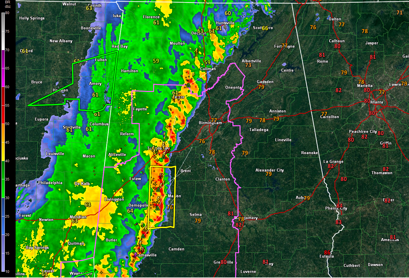
RADAR CHECK AT 1:45 PM
The line of storms now stretches from Skyline up in Jackson County in the northeastern corner of the state back to the southwest to Cullman and Brookwood, then curving to the south to Greensboro and Uniontown in the southern tip of Perry County. At that time, we only have one Severe Thunderstorm Warning for portions of Bibb, Dallas, Hale, Marengo, and Perry counties until 2:45 PM, for wind gusts up to 60 MPH possible.
Temperatures are currently running in the mid-70s to the mid-80s throughout the area out ahead of the line of storms, while temperatures behind the line have dropped into the upper 50s to the mid-60s. Birmingham was at 77 degrees at the time, while Tuscaloosa has dropped to 64 degrees. Haleyville is down to 59 degrees, making it the cool spot. Opposite of that, Eufaula is the warm spot at 85 degrees.
A Tornado Watch continues in effect until 7:00 PM for Autauga, Bibb, Blount, Chilton, Dallas, Hale, Jefferson, Lowndes, Marengo, Perry, Shelby, Tuscaloosa, and Walker counties. Fayette, Greene, Sumter, Lamar and Pickens counties were removed from the watch at 1:00 PM due to the threat for severe weather diminishing.
A Flash Flood Watch continues in effect until 1:00 AM Sunday for Autauga, Bibb, Blount, Chilton, Dallas, Fayette, Greene, Hale, Jefferson, Lamar, Lowndes, Marengo, Marion, Perry, Pickens, Shelby, Sumter, Tuscaloosa, Walker, and Winston counties in Central Alabama, and for Colbert, Cullman, Franklin, Lauderdale, Lawrence, Limestone, and Morgan counties in North Alabama.
At this point, we have only one report of damage, as six trees were downed at the intersection of County Road 49 and Little Hell’s Creek Road just south-southwest of Crossville in Lamar County. Let’s hope that the lack of damage reports continues throughout the remainder of the day.
The National Weather Service in Birmingham launched a special balloon at 18:00 GMT (1 p.m.) That data is in and it indicates that instabilities have increased to about what we thought, around 1,5000 joule/kg. There is a little less moisture available and low level spin has decreased slightly. There is enough low level helicity that we could still see a tornado though. And the bulk shear has increased, indicating that the storms will continue to stay organized. The meteorologists there will probably launch another balloon at 00:00 GMT (7 p.m. CDT).
The airmass ahead of the storms is moderately unstable and there is sufficient speed shear to support organized, severe storms. Damaging winds will be the main threat and the line of storms pushes to the east northeast, and a few tornadoes are possible. There will be lots of lightning and very heavy rain.
Timing for the arrival of the line of storms:
The line is moving east at only 15-20 mph. So i will take a while for the storms make it very far.
Birmingham Metro: 3 p.m. on the western side, 4 p.m. over the eastern sections of the Metro
Clanton: 4:00 p.m. – 5:00 p.m.
Anniston: 5:30 p.m. – 7 p.m.
Category: Alabama's Weather, ALL POSTS
About the Author (Author Profile)
Bill Murray is the President of The Weather Factory. He is the site's official weather historian and a weekend forecaster. He also anchors the site's severe weather coverage. Bill Murray is the proud holder of National Weather Association Digital Seal #0001 @wxhistorianSubscribe
If you enjoyed this article, subscribe to receive more just like it.


