The Severe Thunderstorm Warning For Northeastern Marengo Western Perry Eastern Hale Southwestern Bibb And West Central Dallas Counties Is Cancelled
…THE SEVERE THUNDERSTORM WARNING FOR NORTHEASTERN MARENGO…WESTERN PERRY…EASTERN HALE…SOUTHWESTERN BIBB AND WEST CENTRAL DALLAS COUNTIES IS CANCELLED… The storms which prompted the warning have moved out of the area. Therefore the warning has been cancelled. A tornado watch remains in effect until 700 PM CDT for central, south central, southwestern and west central Alabama.
A Severe Thunderstorm Warning Remains In Effect Until 245 PM CDT For Northeastern Marengo Western Perry Eastern Hale
Apr 14th @ 2:03 pm

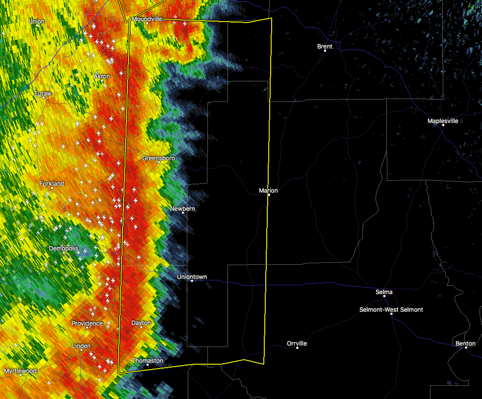
…A SEVERE THUNDERSTORM WARNING REMAINS IN EFFECT UNTIL 245 PM CDT FOR NORTHEASTERN MARENGO…WESTERN PERRY…EASTERN HALE… SOUTHWESTERN BIBB AND WEST CENTRAL DALLAS COUNTIES… At 203 PM CDT, severe thunderstorms were located along a line extending from 6 miles southeast of McFarland Mall to near Consul, moving northeast at 25 mph.
HAZARD…60 mph wind gusts.
SOURCE…Radar indicated.
IMPACT…Expect damage to roofs, siding, and trees. Locations impacted include… Marion, Uniontown, Newbern, Vaiden, Low Gap, Mertz, Central Mills, Perry County Correctional Center, Morgan Springs, Safford, Folsom, Phipps, Vaiden Field Airport and Wateroak.
Severe Thunderstorm Warning Issued For Parts Of Bibb, Dallas, Hale, Marengo, And Perry Counties Until 2:45PM
Apr 14th @ 1:39 pm

The National Weather Service in Birmingham has issued a
* Severe Thunderstorm Warning for…
Northeastern Marengo County in southwestern Alabama…
Western Perry County in central Alabama…
Hale County in west central Alabama…
Southwestern Bibb County in central Alabama…
West central Dallas County in south central Alabama…
* Until 245 PM CDT
* At 138 PM CDT, severe thunderstorms were located along a line extending from near Moundville to near Magnolia, moving northeast at 25 mph.
HAZARD…60 mph wind gusts.
SOURCE…Radar indicated.
IMPACT…Expect damage to roofs, siding, and trees.
* Locations impacted include…
Marion, Greensboro, Uniontown, Moundville, Thomaston, Newbern, Faunsdale, Dayton, Vaiden, Central Mills, Greensboro Municipal
Airport, Low Gap, Mertz, Safford, Moundville Airport, Folsom, Mound
State Park, Elliots Creek, Harper Hill and Vaiden Field Airport.
Category: ALL POSTS
About the Author (Author Profile)
Subscribe
If you enjoyed this article, subscribe to receive more just like it.


