Dry Today; Rain Returns Tomorrow
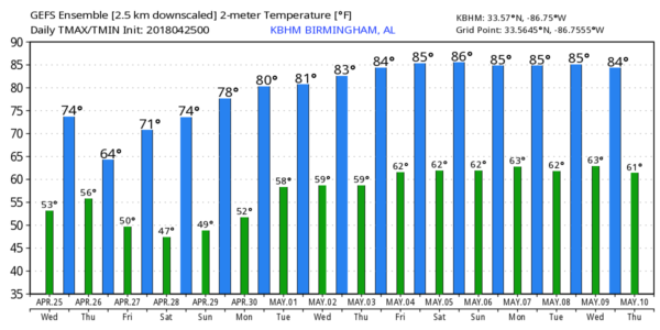
DRY SPRING DAY: The pesky upper low that has produced cloudy periods and scattered showers over the northern half of Alabama in recent days is opening up and lifting out this morning, and we are expecting a dry, pleasant day today with a partly sunny sky along with a high in the 72-75 degree range. Clouds increase tonight ahead of the next wave to the west.
WET DAY TOMORROW: Rain should move into West Alabama during the pre-dawn hours tomorrow, and widespread rain is likely tomorrow morning. Some thunder is possible, but not severe weather is expected, and the rain should taper off by midday with just a few lingering, scattered afternoon showers. Rain amounts tomorrow will be in the 1/2 to 1 inch range for the northern half of the state, with lighter amounts over the southern counties. And, we won’t get out of the 60s because of clouds and rain.
FRIDAY AND THE WEEKEND: Models are trending drier for Friday; a cold front will move through late in the day, and an isolated shower can’t be ruled out, but there just isn’t much moisture available, and it looks like most of the day will be dry with a high in the low 70s along with a mix of sun and clouds. Then a nice surge of dry air rolls in here for the weekend… we are forecasting sunshine in full supply Saturday and Sunday. The high Saturday will be in the mid 70s, followed by upper 70s Sunday.
RACE WEEKEND: Tomorrow looks pretty wet at the Talledega Superspeedway with rain likely during the morning along with a high in the 60s. For Friday, mostly dry with only a small risk of shower; the high will be close to 70 degrees. Then, the weather could not be any better for the weekend. Sunny Saturday and Sunday; highs in the low 70s Saturday followed by upper 70s Sunday for the Geico 500.
NEXT WEEK: An upper ridge builds over the eastern third of the nation, and at this point the week look warm and mostly dry for Alabama. Afternoon highs rise into the low 80s most days; it will be our warmest week so far this year. See the Weather Xtreme video for maps, graphics, and more details.
ON THIS DATE SEVEN YEARS AGO: The four day “superoutbreak” of tornadoes, which lasted from April 25-28, 2011, would begin. By the evening hours of April 25, 2011, multiple tornadoes had been reported across a few states west of Alabama, some of which caused significant damage in Arkansas. An intense supercell thunderstorm tracked near the Little Rock area and a tornado emergency was declared for the city of Vilonia. A large EF2 wedge tornado struck the town, subsequently causing severe damage and killing four people. A strong EF3 tornado had also struck the Hot Springs Village area earlier that evening; that tornado caused severe damage and resulted in one death. Later that evening, Another EF2 tornado caused extensive damage to both a school building and Little Rock Air Force Base as well. A total of 42 tornadoes and four tornado-related deaths were confirmed on the 25th.
BEACH FORECAST: Click here to see the AlabamaWx Beach Forecast Center page.
WEATHER BRAINS: Don’t forget you can listen to our weekly 90 minute netcast anytime on the web, or on iTunes. This is the show all about weather featuring many familiar voices, including our meteorologists here at ABC 33/40.
CONNECT: You can find me on all of the major social networks…
Facebook
Twitter
Google Plus
Instagram
Pinterest
Snapchat: spannwx
I have a weather program this morning at Martin Luther King Jr. Elementary School in Tuscaloosa… be looking for the next Weather Xtreme video here by 4:00 this afternoon. Enjoy the day!
Category: Alabama's Weather, ALL POSTS, Weather Xtreme Videos
About the Author (Author Profile)
James Spann is one of the most recognized and trusted television meteorologists in the industry. He holds the AMS CCM designation and television seals from the AMS and NWA. He is a past winner of the Broadcast Meteorologist of the Year from both professional organizations.Subscribe
If you enjoyed this article, subscribe to receive more just like it.


