

Warm, Humid, Scattered Storms, Watching The Gulf
RADAR CHECK: Most of the active storms across Alabama at mid-afternoon were over the western and southern counties of the state… they are moving slowly southward.
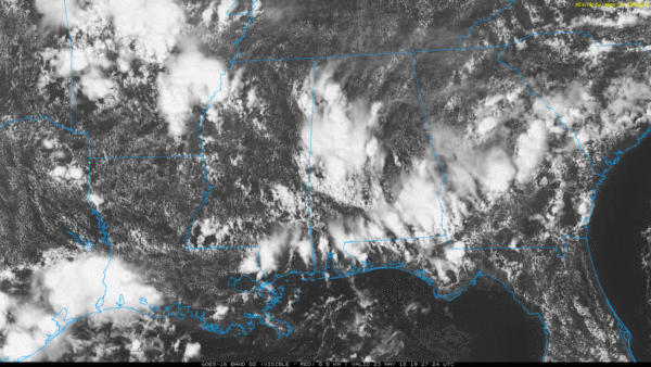
Like recent days, storms are slow movers and are producing very heavy rain. They will diminish late tonight.
TOMORROW/FRIDAY: While a few scattered storms are still possible tomorrow, it could be the driest day of the week as the air aloft should be a little warmer, and the air a bit more stable. With a partly sunny sky we reach the 87-90 degree range by afternoon, and the chance of any one spot getting wet is only about one in five. Then, on Friday, showers and storms should become more numerous as the air aloft cools. The high Friday will be in the mid 80s with a mix of sun and clouds.
MEMORIAL DAY WEEKEND: Warm, humid air will remain over Alabama, and we will need to carry the chance of scattered showers and thunderstorms on through the holiday weekend. The sun will be out at times, and while the storms will be most active during the afternoon and evening hours, we can’t rule out a late night or morning shower.
The wild card in the weekend forecast is a potential tropical low in the Gulf of Mexico. Models are all over the board with huge variations in the potential track and timing. We could see a day with enhanced rain coverage, but it is still simply to early to call. We will just keep scattered storms in the forecast for now, but be aware we might have to ramp up the rain coverage on a day or two later. Highs over the weekend will be in the 80s.
TROPICAL MISCHIEF: NHC is now showing a 60 percent chance of the system in the Gulf becoming a tropical depression over the next five days…
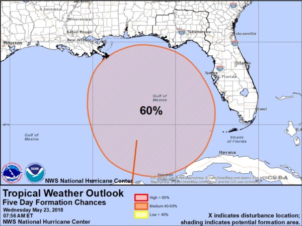
The European global model (12Z run) now keeps the low over the Gulf, near the Louisiana coast, through Tuesday… then moving northward into West Alabama by Wednesday. The American model (12Z GFS) shows a low over North Florida (west of Jacksonville) Sunday, then it drifts into Alabama Monday. Again, a huge difference in track and timing.
Here are the key points if you are planning a trip to the Gulf Coast (Panama City Beach west to Gulf Shores) this weekend:
*The tropical disturbance won’t be a dangerous hurricane or tropical storm, most likely it will be a tropical depression as it moves inland. The main issue will be rain, not wind.
*With the large amount of uncertainty, it is very difficult now to forecast the axis of heavier rain on the Gulf Coast. No doubt some coastal communities could see heavy rain over the holiday weekend, but it remains to be seen which ones.
*There should be some decent intervals of sunshine on the coast Saturday through Monday, but there will be more clouds than sun on these three days.
*The Gulf system will bring potential for dangerous rip currents; if you see red flags flying, don’t get in the water. The risk simply isn’t worth it.
*Click here to see the AlabamaWx Beach Forecast Center page.

NEXT WEEK: The surface low should dissipate over the Gulf Coast states at some point next week, but moist air will remain and the risk of at least scattered storms will continue daily through Friday. Highs will remain in the 80s… see the Weather Xtreme video for maps, graphics, and more details.

PRE-DAWN FLOODING: Rain amounts, based on radar estimates, exceeded four inches over parts of Lee and Russell Counties in East-Central Alabama early this morning in the pre-dawn hours. Some roads were washed away during the flash flooding.
SEC BASEBALL TOURNAMENT: The 2018 SEC Baseball Tournament continues through Sunday at the Hoover Met. Don’t miss some of the best baseball in the country as the top-12 teams will battle it out in Hoover on the road to Omaha. Join us for the indoor FanFest which is free to the public, open each day of the tournament and fun for all ages. Single-session tickets are $18 each for adults and $9 each for kids 3-12. Bleacher seats are first-come, first-served in the General Admission sections. GET YOUR TICKETS HERE!!!
WEATHER BRAINS: Don’t forget you can listen to our weekly 90 minute netcast anytime on the web, or on iTunes. This is the show all about weather featuring many familiar voices, including our meteorologists here at ABC 33/40.
CONNECT: You can find me on all of the major social networks…
Facebook
Twitter
Google Plus
Instagram
Pinterest
Snapchat: spannwx
Look for the next Weather Xtreme video here by 7:00 a.m. tomorrow…
Category: Alabama's Weather, ALL POSTS, Weather Xtreme Videos
About the Author (Author Profile)
James Spann is one of the most recognized and trusted television meteorologists in the industry. He holds the AMS CCM designation and television seals from the AMS and NWA. He is a past winner of the Broadcast Meteorologist of the Year from both professional organizations.Subscribe
If you enjoyed this article, subscribe to receive more just like it.


