Tropical Depression Expected To Form In The Gulf
RADAR CHECK: We have a number of slow moving showers and storms on radar this afternoon across the southern two-thirds of Alabama; heavier storms are generating lots of lighting and very heavy rain. These storms will slowly fade tonight.

TOMORROW/SATURDAY: No real change in our weather. Warm, very humid, and we will deal with scattered showers and storms. They form in random places, and there is no way of knowing far in advance when and where they will pop up; you just have to keep an eye on radar trends. Most of the showers and storms will come during the afternoon and evening hours, but we can’t rule out a late night or morning shower in this airmass. Away from the storms, we will have a mix of sun and clouds with highs in the 80s.
Beyond Saturday, the weather will all depend on a tropical system moving up from the Gulf of Mexico.
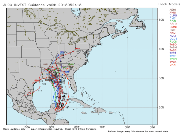
TROPICAL UPDATE: NHC now is showing a 90 percent chance of tropical depression/storm formation in the Gulf over the next five days. Models are coming into better agreement; most take it toward the Mississippi coast on Monday, with a slow journey northward through inland parts of Mississippi Tuesday and Wednesday.
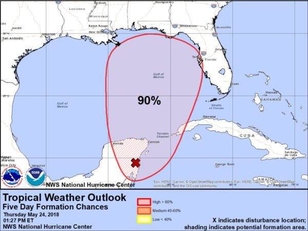
The system will most likely be a minimal tropical storm (it will be called Alberto) at the time of landfall; the main threats will involve rain and flooding, and not wind.
NORTH/CENTRAL ALABAMA: Not totally sure we will see much of a change in the weather Sunday; it will be warm and humid with scattered showers and storms. But, rain coverage should increase Monday, and into Tuesday and Wednesday of next week as the tropical system lifts northward. Rain could be heavy at times, and flooding is as a real possibility for the first half of next week with rain amounts of 3-5 inches.
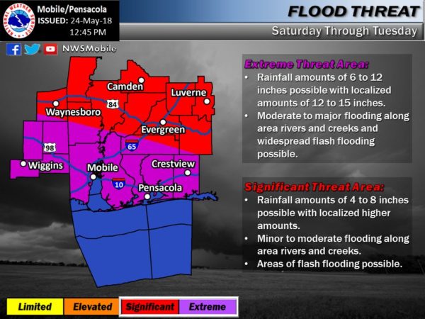
THE GULF COAST: NWS Mobile has already issued a flash flood watch for Mobile and Baldwin counties, and and for Escambia, Okaloosa, and Santa Rosa Counties in Florida. Also, a coastal flood watch is in effect along with a high surf advisory.
The weather Saturday on the coast won’t be too bad with about 2-4 hours of sun, along with scattered showers and storms. However, rain will increase Sunday and Monday with only a limited amount of sun as the tropical system approaches. Here are the key points if you have a beach trip planned…
*The disturbance in the Gulf is not expected to be a hurricane. A fair chance it will be a lower end tropical storm, meaning the main threat is from rain and flooding instead of wind.
*NWS Mobile is now forecasting 6 to 12 inches of rain for the Alabama and Northwest Florida coast Saturday through Tuesday, with potential for isolated amounts of over 12 inches. This, needless to say, will bring a very significant risk of flooding.
*There will be a high danger of rip tides along the coast through Memorial Day; red flags are already flying. Do not get into the waters of the Gulf; the risk is simply not worth it.
*A few isolated, short lived tornadoes will be possible along and east of where the tropical system moves onshore, mainly Monday.
*Weather should begin to improve on the Gulf Coast Monday night and Tuesday as the system moves farther inland.
As is the case with every tropical system, keep an eye on the blog for potential forecast changes in coming days.
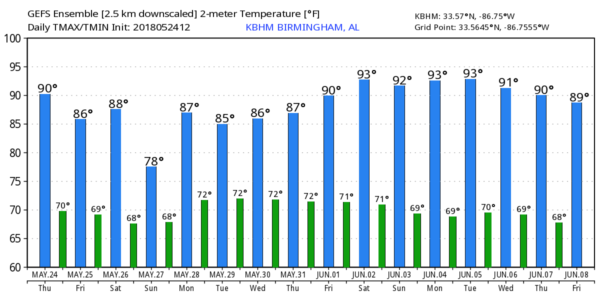
REST OF NEXT WEEK: The tropical system should dissipate across the Gulf Coast states by the middle of next week, and showers and storms should become fewer in number by Friday. Highs through the week will be in the 80s. See the Weather Xtreme video for maps, graphics, and more details.
SEC BASEBALL TOURNAMENT: The 2018 SEC Baseball Tournament continues through Sunday at the Hoover Met. Don’t miss some of the best baseball in the country as the top-12 teams will battle it out in Hoover on the road to Omaha. Join us for the indoor FanFest which is free to the public, open each day of the tournament and fun for all ages. Single-session tickets are $18 each for adults and $9 each for kids 3-12. Bleacher seats are first-come, first-served in the General Admission sections. GET YOUR TICKETS HERE!!!
WEATHER BRAINS: Don’t forget you can listen to our weekly 90 minute netcast anytime on the web, or on iTunes. This is the show all about weather featuring many familiar voices, including our meteorologists here at ABC 33/40.
CONNECT: You can find me on all of the major social networks…
Facebook
Twitter
Google Plus
Instagram
Pinterest
Snapchat: spannwx
Look for the next Weather Xtreme video here by 7:00 a.m. tomorrow…
Category: Alabama's Weather, ALL POSTS, Weather Xtreme Videos
About the Author (Author Profile)
James Spann is one of the most recognized and trusted television meteorologists in the industry. He holds the AMS CCM designation and television seals from the AMS and NWA. He is a past winner of the Broadcast Meteorologist of the Year from both professional organizations.Subscribe
If you enjoyed this article, subscribe to receive more just like it.


