Wet + Alberto = Really Wet
Graphics note: for some reason I am unable to access the graphics I typically use, so everything will look a little strange. Thanks for your patience with this issue. I hope to have it corrected by the Weather Xtreme Video on Sunday morning.
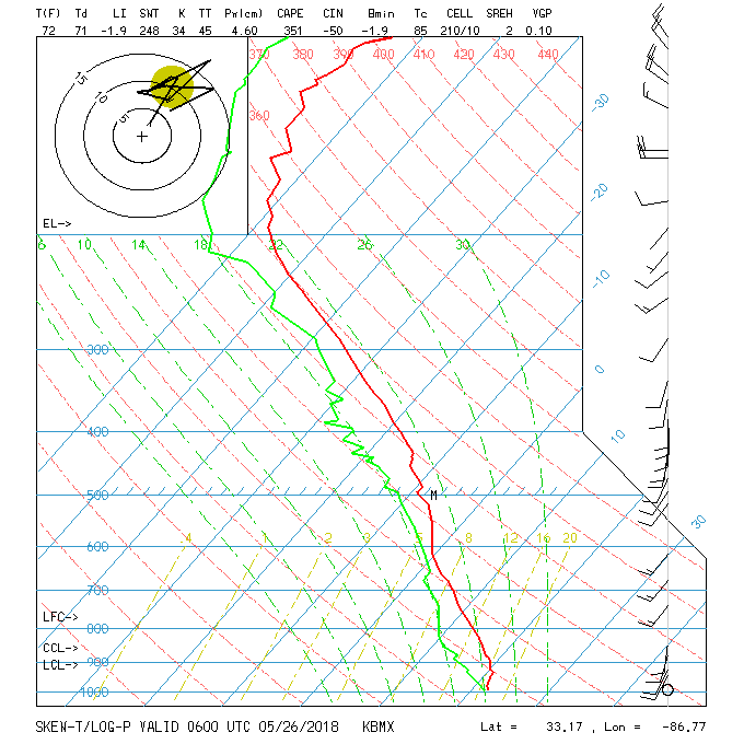
Clouds covered parts of Alabama this morning. This is not surprising due to the tremendous amount of coverage of showers and thunderstorms that we saw yesterday. Little has changed in our atmosphere as it remained very wet as seen in the sounding last night. Precipitable water value stood at 1.81 inches. That helps to account for the 2.04″ of rain in my rain gauge in Helena.
The best forecast for today is a persistent one as showers and thunderstorms will again have a pretty significant coverage across Alabama. Highs with all the clouds and storms should be held in the lower 80s.
All eyes, of course, are on developing subtropical storm Alberto still in the northwestern Caribbean. The future course of Alberto should take it generally northward into the eastern Gulf and then curve it slightly westward with landfall along the Central Gulf Coast on Tuesday morning. Alberto is forecast to arrive on the coast as a subtropical storm, so high wind should not be an issue. Heavy rain along with strong rip currents will be issue for coastal residents and visitors. Sunday and Monday do not look like good days on the beach, but conditions should improve after that. As James noted yesterday, you might not want to cancel plans because of some rough weather for a couple of days – it all depends on what you go to the Gulf Coast to experience.
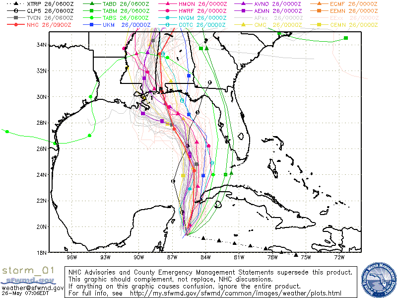
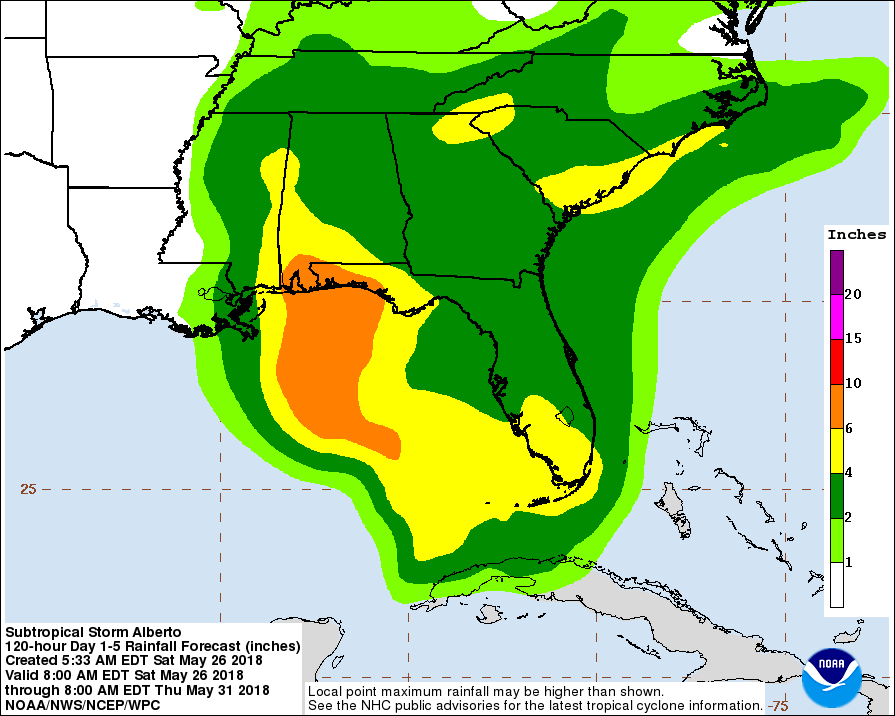
The big issue will be heavy rain and flooding with 6 to 10 inches of rain forecast along the Gulf Coast and just inland from about Panama City to Mobile. 4 to 6 inches will be possible along and just east of the track of the storm along the Alabama-Mississippi line with 2 to 4 inches over a very large portion of the Southeast US. See the NHC graphic below.
Alberto is forecast to move into Northeast Mississippi on Tuesday and then get picked up by the strong westerlies on Wednesday. Unfortunately this leaves the moist air mass in place, so we don’t dry out completely as we return to a typical summer-like pattern of afternoon and early evening showers and thunderstorms. Our highs for the latter half of the week will inch upward, too, with upper 80s returning and the potential to hit 90 or the lower 90s.
But the GFS does promise a bit of a break by Saturday. A strong upper closed low is forecast to dig into the Mid-Atlantic area by Saturday. If this happens as depicted, we should see a big change in our weather with drier and cooler air coming into the Southeast US from the north and northwest. But since we’re verging on voodoo country here, we’ll temper the forecast for the time being but keep a hopeful eye on the potential change.
SEC BASEBALL TOURNAMENT: The 2018 SEC Baseball Tournament continues through Sunday at the Hoover Met. Don’t miss some of the best baseball in the country as the top-12 teams will battle it out in Hoover on the road to Omaha. Join us for the indoor FanFest which is free to the public, open each day of the tournament and fun for all ages. Single-session tickets are $18 each for adults and $9 each for kids 3-12. Bleacher seats are first-come, first-served in the General Admission sections. GET YOUR TICKETS HERE!!!
WEATHER BRAINS: Don’t forget you can listen to our weekly 90 minute netcast anytime on the web, or on iTunes. This is the show all about weather featuring many familiar voices, including our meteorologists here at ABC 33/40.
Thanks for tuning in to the Weather Xtreme Video. I am providing weather support to the SEC Baseball Tournament at the Hoover Met today and Sunday, so I will be watching the radar for much of the next two days. I will have the next Weather Xtreme Video posted here on Sunday morning. Godspeed.
-Brian-
.
Category: Alabama's Weather, ALL POSTS, Weather Xtreme Videos
About the Author (Author Profile)
Brian Peters is one of the television meteorologists at ABC3340 in Birmingham and a retired NWS Warning Coordination Meteorologist. He handles the weekend Weather Xtreme Videos and forecast discussion and is the Webmaster for the popular WeatherBrains podcast.Subscribe
If you enjoyed this article, subscribe to receive more just like it.


