

A Quick Update On Central Alabama’s Weather Before 10:00 PM
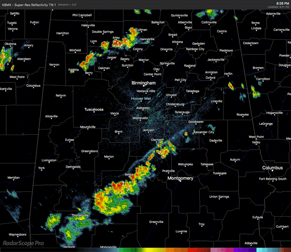
We have two lines of showers and thunderstorms that are moving northward as of 9:35 PM, with the strongest cells at this point over parts of Chilton and Coosa counties. Very heavy rainfall and frequent lightning are occurring with this cluster. This is part of a larger broken line that is stretching from the southwestern parts of Dallas County to the northwest through Chilton and Coosa counties and ending in the southern parts of Talladega and Clay counties.
A smaller line of showers and storms is located in the north and northwestern parts of Central Alabama about to cross over into North Alabama. This line is stretching from northwestern Fayette County over to the northeastern parts of Cullman County. Heaviest rain in this line is falling over the communities of Natural Bridge, Lynn, and Nauvoo at the moment.
There is one other small cluster of storms located over the northern half of Cleburne County, affecting the communities of Borden Springs and Liberty Hill. Once again, all of these are moving at a decent speed to the north. All of these storms may persist for a few more hours, but should finally dissipate by 2:00 AM.
The next advisory on Subtropical Storm Alberto will be out shortly. We’ll have an update on the blog.
Category: Alabama's Weather, ALL POSTS
About the Author (Author Profile)
Scott Martin is an operational meteorologist, professional graphic artist, musician, husband, and father. Not only is Scott a member of the National Weather Association, but he is also the Central Alabama Chapter of the NWA president. Scott is also the co-founder of Racecast Weather, which provides forecasts for many racing series across the USA. He also supplies forecasts for the BassMaster Elite Series events including the BassMaster Classic.Subscribe
If you enjoyed this article, subscribe to receive more just like it.


