

With The Latest Update Out, Here’s What To Expect Along The Coast With Alberto
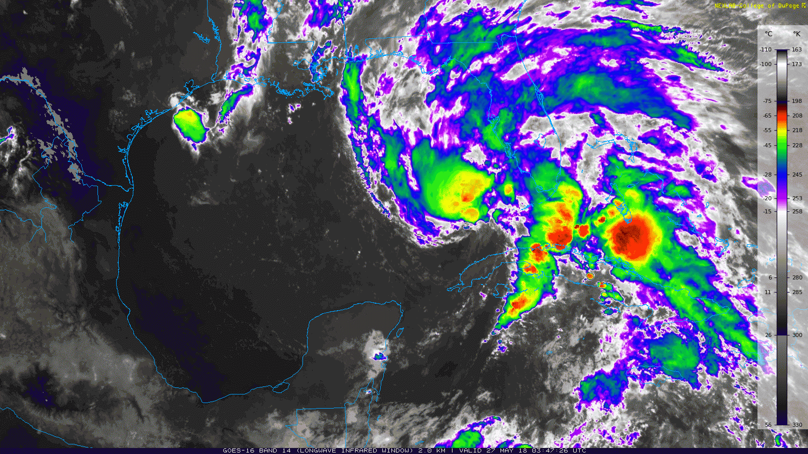
With the latest update that came out from the National Hurricane Center just after 10:00 PM tonight, we can see that another reformation of the center of Alberto has taken place during the last few hours thanks in part to a burst of convection that has formed just to the north of the center. Even with an overall increase in the storm’s organization, Hurricane Hunter aircraft cannot find any stronger winds than the 40 MPH maximum sustained that we have seen for quite a while. That may hold true as the central pressure has not fallen since the last Hurricane Hunter mission through the storm, and that pressure holds at 1001 mb.
With a negative-tilted trough just west of Alberto, there should be some intensification over the next 24-hours due to the trough becoming a cut-off upper-level low which will cause wind shear levels to drop. This should allow Alberto’s core to become warmer and deeper and become more symmetric, transforming the subtropical storm into a standard tropical storm within the next 36-48 hours.
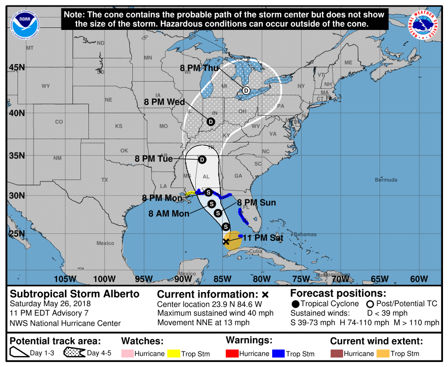
Alberto is forecast to move generally northward for the next 12 hours, then begin to move more north-northwestward as it merges with the upper level cut-off low. On the current track, the center of Alberto should make landfall late on Monday evening somewhere between Pensacola and Fort Walton Beach as a strong tropical storm (maximum sustained winds of 65 MPH with gusts up to 75 MPH). There is a very small chance that Alberto may briefly become a hurricane just before landfall, but that is a very low risk.
The key messages that we have to remember with Alberto:
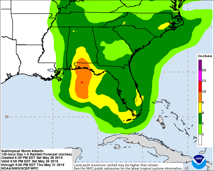
No matter where the exact landfall of the center of circulation occurs, very heavy rain and some flash flooding is expected along the Gulf Coast from Fort Morgan, Alabama, to Panama City Beach, Florida and possibly well inland into the southern parts of Alabama and Georgia starting on Sunday and persisting into Tuesday. 4-10 inches of rainfall is expected in parts of northwest Florida and extreme southern Alabama.
Dangerous storm surge is possible for locations on the Gulf Coast especially for those that will be east of the center. Dangerous surf and rip currents will also take place along the Gulf Coast from now through Monday evening.
Tropical storm conditions along the northern Gulf Coast under the Tropical Storm Warning will begin on Sunday night. A few brief, spin-up, tropical tornadoes may be possible on the east and northeastern sides of the storm. If your location just happens to fall in that part of the storm, once the center passes your location, the tornado threat will come to an end.
Conditions will begin to improve along the Gulf Coast on Tuesday, as the effects of Alberto start to move well up into the north and central parts of Mississippi, Alabama, and Georgia. By Wednesday, we’ll return to a more typical weather pattern as we should see a good bit of sun each day with the daily risk of a scattered thunderstorm.
Watches and warnings in effect along the Gulf Coast:
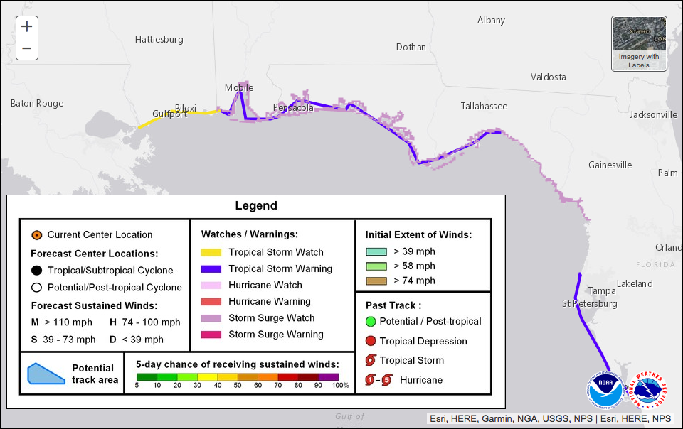
A Tropical Storm Warning is in effect from the Alabama/Mississippi state line to the Aucilla River at the Big Bend of the Florida Panhandle.
A Tropical Storm Watch is in effect from the mouth of the Pearl River at the Mississippi/Louisiana state line to the Alabama/Mississippi state line.
A Storm Surge Watch is in effect from the Alabama/Mississippi state line to the Crystal River in Florida.
A Flash Flood Watch is in effect Saturday evening through Tuesday evening for all of south Alabama, a portion of southwest Georgia, northwest Florida, a portion of southeast Mississippi, and southeastern Louisiana.
Category: Alabama's Weather, ALL POSTS
About the Author (Author Profile)
Scott Martin is an operational meteorologist, professional graphic artist, musician, husband, and father. Not only is Scott a member of the National Weather Association, but he is also the Central Alabama Chapter of the NWA president. Scott is also the co-founder of Racecast Weather, which provides forecasts for many racing series across the USA. He also supplies forecasts for the BassMaster Elite Series events including the BassMaster Classic.Subscribe
If you enjoyed this article, subscribe to receive more just like it.


