

Latest Thoughts On Alberto’s Impacts On Central Alabama

Tropical Storm Warning Issued For Southeast Alabama
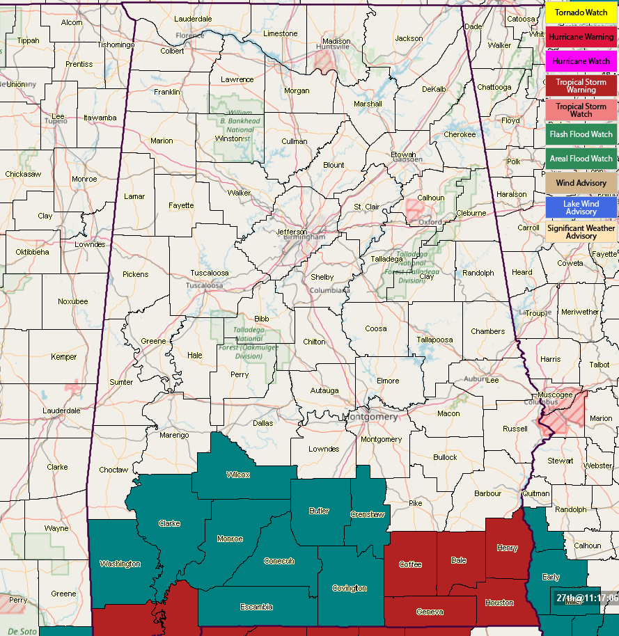
A Tropical Storm Warning has been issued for Coffee, Dale, Geneva, Henry, and Houston counties in the southeastern parts of the state.
Weather For Your Sunday In Central Alabama
Today’s weather will continue to be similar to what we have seen over the past ten days in Central Alabama… warm and very humid with some sun with scattered showers and thunderstorms developing mainly during the afternoon hours. Precipitable water values are above 1.75″ which means any storms that develop has the potential of putting down copious amounts of rain in a short about of time and some localized flash flooding is possible in poor drainage areas. Highs will top out in the mid to upper 80s throughout the area.
As we get to this evening, the first rain bands will begin to move into the area from the south, bringing tropical showers and a few thunderstorms. These showers should make it up to the I-20 corridor during the late night and into the overnight hours. Rainfall could be heavy at times, but amounts from these first bands will be around 0.25″ to 0.50″. Overnight lows will be in the upper 60s to the lower 70s.
We’ll Really Start Seeing Alberto’s Impacts On Monday
During the day on Monday, we will see mainly cloudy skies with the sun peeking through for very short amounts of time. Winds will start picking up in the southern parts of the area, mainly from Montgomery southward during the afternoon. There is a possibility for a few bands of heavier tropical showers and storms during the morning, but the main rain shield from Alberto will start spreading into the southern portions of the area by mid-afternoon. Highs will top out in the lower to mid-80s.
By the time we reach the late evening hours, sustained winds will begin increasing in the southern parts of the area, possibly reaching 20 MPH with gusts up to 30 MPH for locations along and south of I-85 by 9:00 to 10:00 PM. Those winds should reach the Birmingham metropolitan area and the I-20 corridor just after midnight. Lows will be in the upper 60s to the lower 70s.
The Center Of Alberto Starts Tuesday Off Near Birmingham
By the time most people start heading off to work, the center of Alberto should be very near to the Magic City. We could see some gusty winds closest to the center, averaging around 10-15 MPH with gusts of 20-25 MPH possible. Alberto’s forward motion will accelerate as it will start to be picked up by the westerlies and the center should be out of the state by the late afternoon or early evening hours.
Impacts On Central Alabama
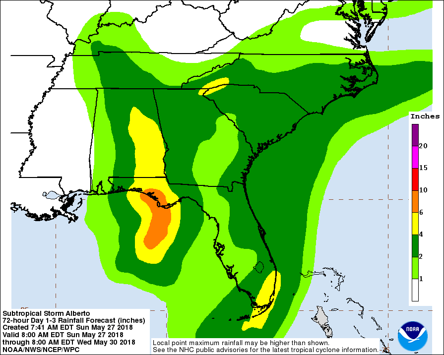
FLOODING: The main threat from Alberto to Central Alabama will be from very heavy rainfall and the possibility of flash flooding. Rainfall totals along and east of I-65 could be as high as 4.00″-6.00″. Flash flood watches are already in effect for south Alabama and could be issued for the eastern parts of the area later today.
WIND: Stongest winds associated with Alberto should be around 20-30 MPH with gusts up to 40 MPH possible. A few trees will fall and a few scattered power outages are possible, but fortunately these winds should not cause serious damage or major power outages.
TORNADOES: A few spin-up tornadoes are possible on the east and northeastern sides of the storm as it moves through Central Alabama. With the current forecast track, the main threat for these will be east of I-65.
Weather For The Remainder Of The Week After Alberto Leaves
The remnants of Alberto will be speeding off to the northeast after it is picked up by the westerlies on Wednesday, unfortunately leaving very moist air in place over Central Alabama. This means we will return to the same weather pattern that we’ve seen over the past 7-10 days in the area… very warm and humid with some sun at times, and the daily risk of scattered afternoon and early evening showers and thunderstorms. Highs will be back up in the upper 80s to the lower 90s.
Category: Alabama's Weather, ALL POSTS
About the Author (Author Profile)
Scott Martin is an operational meteorologist, professional graphic artist, musician, husband, and father. Not only is Scott a member of the National Weather Association, but he is also the Central Alabama Chapter of the NWA president. Scott is also the co-founder of Racecast Weather, which provides forecasts for many racing series across the USA. He also supplies forecasts for the BassMaster Elite Series events including the BassMaster Classic.Subscribe
If you enjoyed this article, subscribe to receive more just like it.


