

A Quick Look At Central Alabama’s Weather At Midday
Conditions In Central Alabama Just Before The Noon Hour
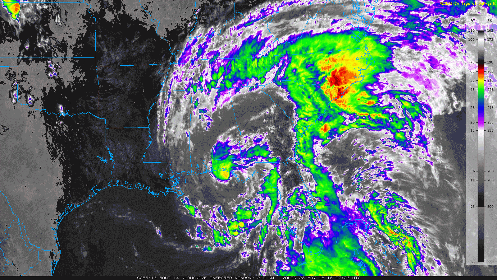
As you can tell by the above image, the center of Alberto is beginning his final approach to the northwest Florida Gulf Coast, with landfall expected to take place just west of Panama City Beach very near to Laguna Beach within the next hour or two. Maximum sustained winds are forecasted to be around 60 MPH at landfall, with gusts up to 70 MPH possible.

Radar is showing at this point that the rain band that moved through the area earlier is still lingering around over the extreme northern and northwestern parts of Central Alabama. The heaviest downpour at this point is located over Jasper, while the rest of the band has diminished down to light rain. Another decent group of showers is located over portions of Sumter, Greene, and Pickens counties. All of these are creeping to the west around 10 MPH.
More tropical showers are starting to form into another rain band down in the southeastern corner of Central Alabama, with a few spotty showers to the north of those. These are generally moving to the west-northwest.
What To Expect Later This Afternoon And Into The Evening
Skies will continue to stay generally cloudy throughout the remainder of the afternoon and into the early evening hours, with more rain bands expected to move northward from Alberto. Some thunder can be expected in those rain bands, along with some heavy downpours at times. Afternoon highs should top out in the upper 70s to the lower 80s.
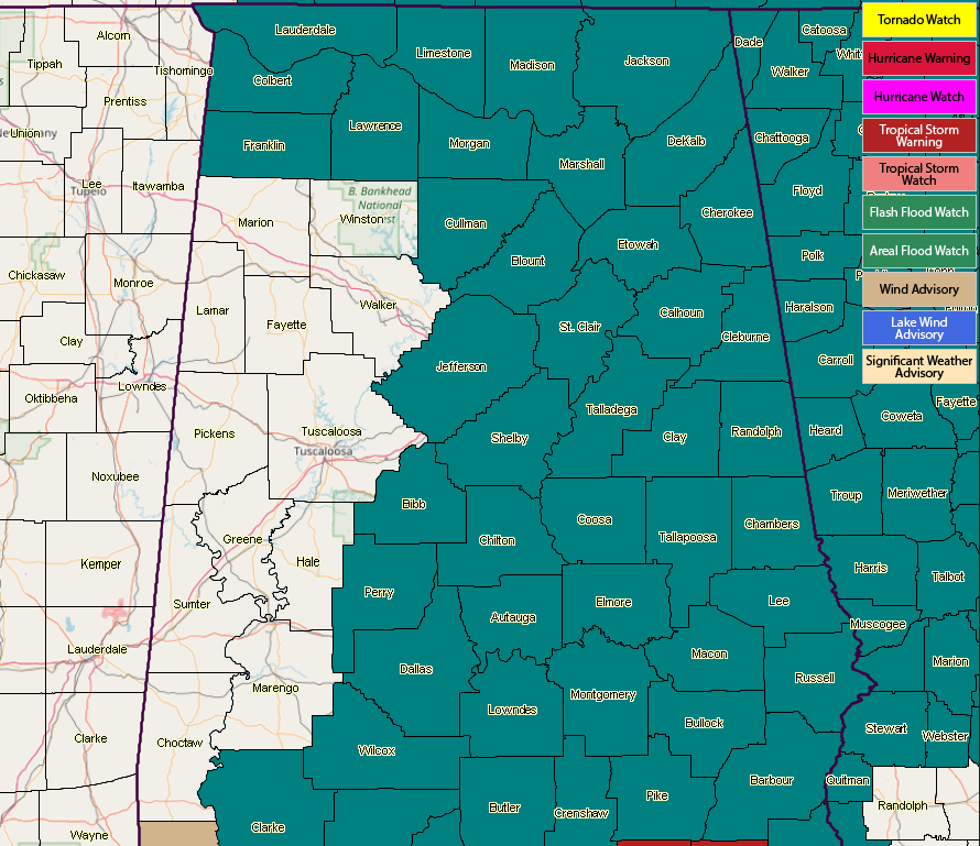
A Flash Flood Watch goes into effect for the eastern two-thirds of Central Alabama starting at 1:00 PM this afternoon and is set to expire at 7:00 PM Tuesday. We still have the potential for 4-6 inches of rain to fall over the counties in the watch, with the rest of the area with the possibility of 1-3 inches of rain.
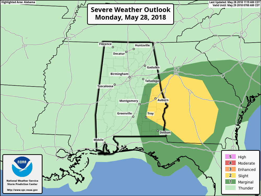
There is a Slight Risk for severe storms for the remainder of today through 7:00 AM Tuesday defined in the southeastern parts of Central Alabama for locations east of a line from Troy (Pike Co.) to Daviston (Tallapoosa Co.) to Roanoke (Randolph Co.). A Marginal Risk for severe storms has been defined stretching westward from the slight risk area to a line stretching from roughly Montgomery to Goodwater (Coosa Co.) to Ranburne (Cleburne Co.). The main threat will be from gusty winds associated with Alberto, along with the possibility for a few spin-up tornadoes.
A Wind Advisory goes into effect at 1:00 PM today for Autauga, Barbour, Bullock, Chambers, Chilton, Coosa, Dallas, Elmore, Lee, Lowndes, Macon, Montgomery, Pike, Russell, and Tallapoosa counties. It is set to expire at 7:00 AM Tuesday. Winds of 20-30 MPH with gusts up to 40 MPH will be possible starting in the southeastern parts of the area and slide northward throughout the evening.
On This Day In Weather History
1987 – Thunderstorms produced torrential rains in Oklahoma and northern Texas. Lake Altus, OK, was deluged with nine inches of rain. Up to eight inches drenched northern Texas, and baseball size hail was reported north of Seminole and at Knickerbocker. Ten to 13 inch rains soaked central Oklahoma the last five days of May resulting in an estimated 65 million dollars damage, and forcing several thousand persons to evacuate their homes, many by boat or helicopter.
Beach Forecast Center
With Alberto making an impact on the Gulf Coast, now is a great time to check it out! Get the latest weather and rip current forecasts for the beaches from Fort Morgan to Panama City on our Beach Forecast Center page. There, you can select the forecast of the region that you are interested in.
WeatherBrains
Don’t forget you can listen to our weekly 90 minute netcast anytime on the web at WeatherBrains.com or on iTunes. This is the show all about weather featuring many familiar voices, including the meteorologists at ABC 33/40.
E-Forecast
Get the AlabamaWx Weather Blog’s Seven-Day Forecast delivered directly to your inbox by email twice daily. It is the most detailed weather forecast available in Central Alabama. Subscribe here… It’s free!
Advertise With Us
Don’t miss out! We have enjoyed over 9.7 MILLION page views on AlabamaWx.com since the start of 2018. We can customize a creative, flexible and affordable package that will suit your organization’s needs. Contact Bill Murray at (205) 687-0782.
Category: Alabama's Weather, ALL POSTS
About the Author (Author Profile)
Scott Martin is an operational meteorologist, professional graphic artist, musician, husband, and father. Not only is Scott a member of the National Weather Association, but he is also the Central Alabama Chapter of the NWA president. Scott is also the co-founder of Racecast Weather, which provides forecasts for many racing series across the USA. He also supplies forecasts for the BassMaster Elite Series events including the BassMaster Classic.Subscribe
If you enjoyed this article, subscribe to receive more just like it.


