Summertime Weather
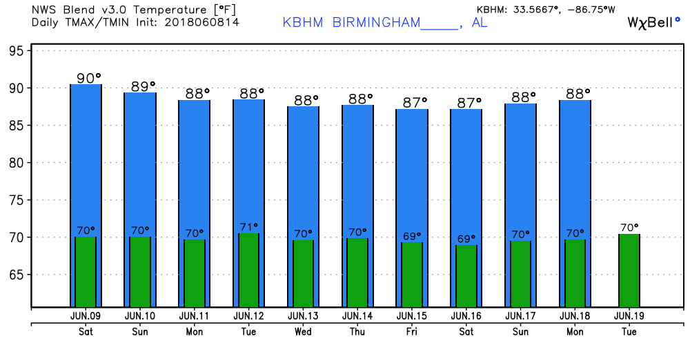
The satellite view this morning showed some patchy clouds in spots especially along the Alabama/Georgia line where convection lasted into the evening Friday. Most locations in Central Alabama were around 70 degrees for morning lows. As we saw yesterday, isolated showers and thunderstorms will develop once again driven by the heat of the afternoon with highs topping out in the lower 90s.
We’re getting into that time of year when we don’t see a great deal of change in the overall weather pattern from day to day. The upper level pattern starts out with a slight weakness over the Southeast US with ridging occurring just to our west. The ridging gradually degrades the weakness aloft, but the ridging remains somewhat suppressed as the main westerlies push traveling weather systems across southern Canada. This keeps us in a generally soupy air mass with plenty of moisture and the expectation of daily convection without much skill in forecasting any significant change in the day to day weather with the probability of rain running in the 30 to 40 percent range.
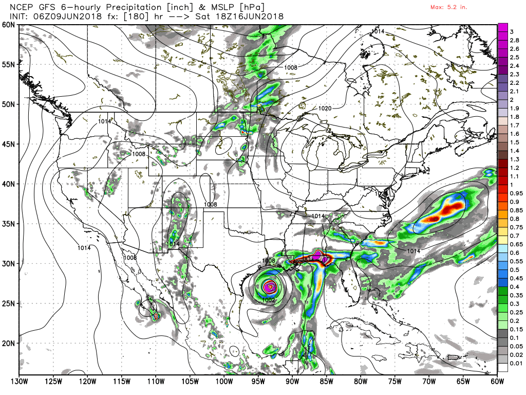
Precipitable water remains relatively high all week with values in the 1.7 to 1.9 inch range. Highs will be topping out most days in the lower 90s and I’m optimistic that we stay below the level for any serious heat index values. But there is a serious problem in the GFS starting about Thursday. The GFS begins to develop a low over the Yucatan on Thursday, but there is no such feature in the ECMWF. The GFS is very bullish on this feature, so there is very little confidence in the GFS solutions for the latter half of the week and into next weekend with the two models so vastly different. We’ll probably see a change tomorrow, but will the ECMWF begin to develop a system moving toward the GFS or will the GFS cut back on the development in the Gulf as it moves toward the ECMWF solution? Be sure to tune-in tomorrow to see which way it goes – or if it stays the same. It is worth noting here that the Canadian model also shows no system in the Gulf until after next weekend which places the GFS as a real outlier. We’ll see.
Because the GFS is so bullish on a tropical system late next week, I don’t have much confidence in the forecast highs. For now I think the prudent path is to stick with highs around 90 or the lower 90s.
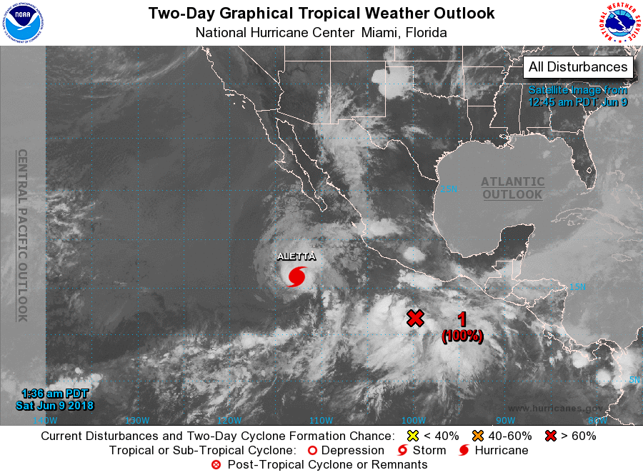
The tropics are quiet in the Atlantic Basin but active in the Pacific with Hurricane Aletta. Aletta is forecast to weaken to a depression by Monday as it remains well out in the ocean. Another area of disturbed weather was located off the southern coast of Mexico with a high potential to become a depression or tropical storm later today or Sunday.
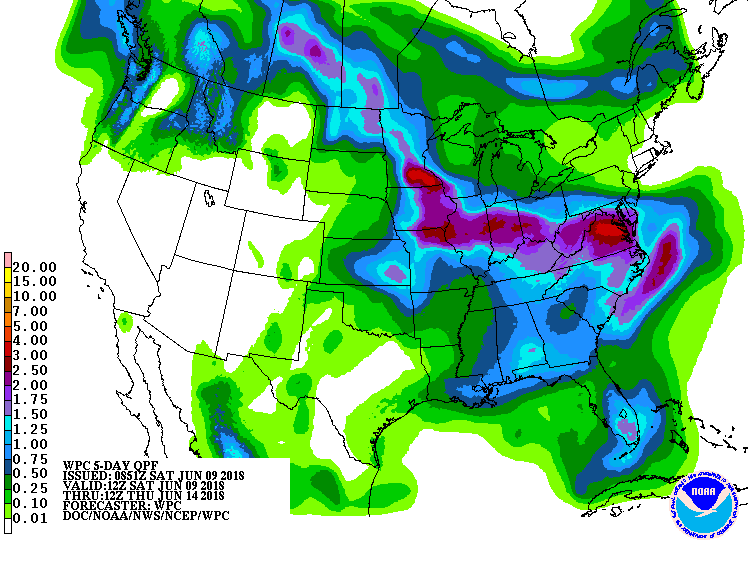
With the main westerlies pushed pretty far north of us, the expected rainfall over the next 5 days will be pretty much a hit or miss situation. The QPF chart indicates the potential for a half inch to 1 inch of rain for Central Alabama. This is actually probably a pretty good forecast seeing that any showers or storms that do form will probably not move much so some spots could get a good dousing. But it also means that some spots may see nothing.
Looking out into voodoo country, the confidence is not very high on the GFS solution due to the differences with other models into the latter part of next week. The upper air pattern does not change much well into week 2, so not expecting to see any change to the scattered showers on a daily basis. But the GFS is suggesting a strong trough toward the end of the forecast period – 372 hours – that just might bring a cold front into the Southeast US. While we don’t see fronts very often in the summer, we sometimes do get one, but I’m not going to be holding my breath for this one.
BEACH FORECAST: Click here to see the AlabamaWx Beach Forecast Center page.
WEATHERBRAINS: Don’t forget you can listen to our weekly 90 minute netcast anytime on the web, or on iTunes. This is the show all about weather featuring many familiar voices, including our meteorologists here at ABC 33/40.
Be sure to take any afternoon storms seriously. Lightning has been responsible for 4 deaths in the US already this year, and we are just getting into the season for outdoor activities. When thunder roars, stay indoors! I expect to have the next Weather Xtreme Video posted here around 7 am or so on Sunday. Have a great day and Godspeed.
-Brian-
Category: Alabama's Weather, ALL POSTS, Weather Xtreme Videos
About the Author (Author Profile)
Brian Peters is one of the television meteorologists at ABC3340 in Birmingham and a retired NWS Warning Coordination Meteorologist. He handles the weekend Weather Xtreme Videos and forecast discussion and is the Webmaster for the popular WeatherBrains podcast.Subscribe
If you enjoyed this article, subscribe to receive more just like it.


