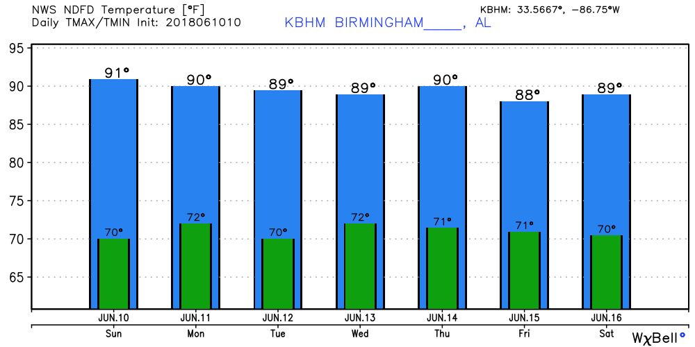
Daily Storms Continue with Humid Air Mass
Once again we see patchy clouds across the Alabama sky thanks to the convection which lasted well into the evening yesterday. Today is not expected to be much different from yesterday with scattered thunderstorms forecast to develop in the heat of the afternoon and last into the evening hours. As we saw from radar yesterday, the upper flow over the Southeast US is very weak so thunderstorms will move very little with most of the movement coming from propagation of cells versus actual translation of cells. Highs again will be in the upper 80s to lower 90s for North and Central Alabama.
The upper air weakness over the Southeast US remains visible through Tuesday. By Wednesday it is finally pushed off to the east as the upper ridge to our west extends its influence eastward and northward. With the main westerlies well to our north, there is no evidence that we’ll see any kind of air mass change as we stay stuck in the soup with precipitable water values running above 1.7 inches. So look for the daily production of showers and thunderstorms with highs staying around the 90-degree mark for nearly everyone in Central Alabama.
The GFS does indicate a slight uptick in the probability of precipitation on Wednesday as the weakness is pushed away. This could mean better coverage to showers and storms with more of us getting wet.
Rainfall amounts through Friday morning are still forecast to be around 1 inch for those that get showers. As I mentioned yesterday, not everyone will get an inch of rain due to the showery nature of the precipitation. Last night the strong thunderstorm that developed over Bessemer apparently produced a wet microburst and out SkyWatcher reported 1.18 inches of rain. That some storm propagated toward the east-southeast and I recorded about a third of an inch.
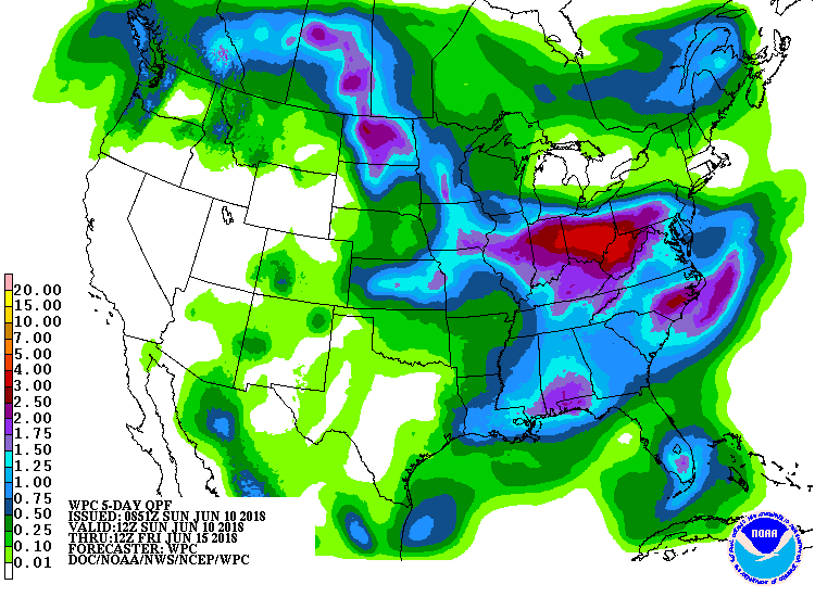
Much like we saw yesterday, the GFS is still trying to suggest the development of a tropical system in the vicinity of the Yucatan Peninsula by Friday. The GFS remains the outlier as the ECMWF and the Canadian models show nothing like that. The ECMWF does show an area of showers over the Northwest Gulf on Saturday, but the pressure pattern is free of any kind of low pressure area. Unfortunately this makes the GFS charts beyond next Friday somewhat suspect since the GFS actually carries an upper reflection of the system into the Lower Mississippi River Valley by Sunday and Monday. For Central Alabama it appears that we stay moist with those daily showers to deal with. Highs still expected to be around the 90-degree mark.
Looking into voodoo country despite the issue of a tropical system, the GFS is suggesting a change. By Wednesday, June 20th, the GFS has a substantial trough moving into the Mississippi River Valley which should help to lower the temperatures across the eastern half of the country for a few days. The GFS keeps a broad trough over the eastern US through June 24th. This is one of those situations where my hopeful side really likes this solution because it takes away the heat and oppressive humidity. But my logical side says we don’t often see broad troughs like this in the summer months, so I’m a bit skeptical of this solution. I don’t think I’m going to place any bets on this happening. I’d probably be better off placing a bet on this whole broad trough being gone in the next model run!! Such are things in voodoo country.
BEACH FORECAST: Click here to see the AlabamaWx Beach Forecast Center page.
WEATHERBRAINS: Don’t forget you can listen to our weekly 90 minute netcast anytime on the web, or on iTunes. This is the show all about weather featuring many familiar voices, including our meteorologists here at ABC 33/40.
I hate to report that there was another lightning fatality in the US yesterday. A man working in his yard in Arkansas is the latest and fifth fatality from lightning reported this year. Summer thunderstorms deserve all of our respect which means we need to cease activities when storms are in our vicinity. James Spann will be back with the next edition of the Weather Xtreme Video on Monday morning. Enjoy the day and Godspeed.
-Brian-
.
Category: Alabama's Weather, ALL POSTS, Weather Xtreme Videos
About the Author (Author Profile)
Brian Peters is one of the television meteorologists at ABC3340 in Birmingham and a retired NWS Warning Coordination Meteorologist. He handles the weekend Weather Xtreme Videos and forecast discussion and is the Webmaster for the popular WeatherBrains podcast.Subscribe
If you enjoyed this article, subscribe to receive more just like it.


