Storms Today, a Little Less Active Afterward
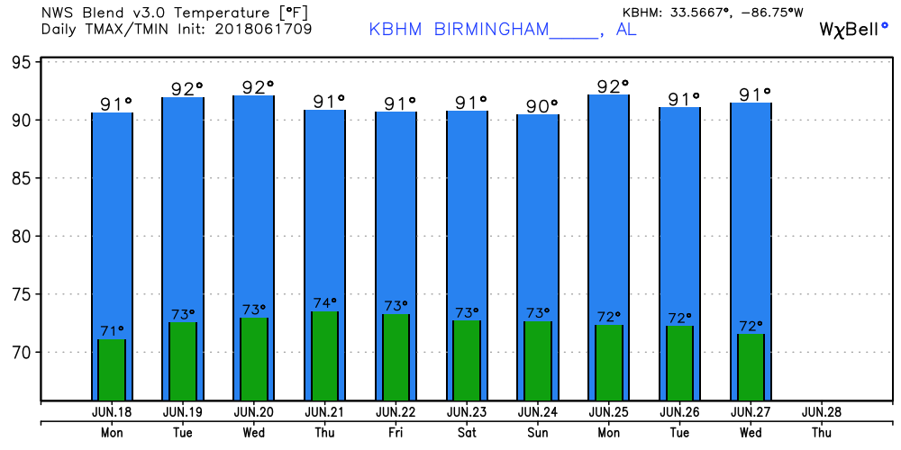
A few clouds were leftover in the Alabama sky this Father’s Day morning from the active convection from Birmingham southward yesterday afternoon and evening. Radar showed one storm still going this morning from just east of Tuskegee in Macon County to southeast of Columbus, GA, moving generally east-southeast. The Southeast US remains in a humid air mass, so thunderstorms are likely once again this afternoon and into the evening hours. With a fairly substantial ridge aloft, temperatures will remain warm with highs in the lower 90s.
In the tropical Atlantic, there is an area of disturbed weather in the Central Gulf that is chugging northwestward and will bring heavy rain to the Northwest Gulf and southern Texas later today and into the first part of the week. QPF forecasts suggest 7 to 10 inches of rain will be possible with this system from the Victoria-Palacios area southward to Brownsville through next Friday morning. The ECMWF seemed even more aggressive with this system in terms of rainfall. Fortunately, conditions do not appear likely for any significant strengthening of this area of disturbed weather.
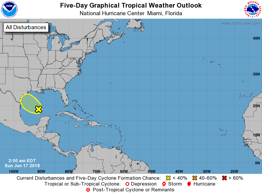
In the Eastern Pacific, Bud has dissipated but TS Carlotta has formed very close to the Mexican coast. Carlota is forecast to dissipate over the next 36 hours as it comes ashore.
The weather pattern over the Central and Southeast US featured a substantial upper ridge bringing heat advisories and warnings to the Central US. The Southeast US stays under heat advisory criteria due in part to the high humidity levels. Precipitable water values from the sounding at the Shelby County airport last night were close to 2 inches, so we remain in the soup with showers and thunderstorms likely today. With the upper flow very weak, storms will change little producing heavy rains in spots. Unfortunately, some spots might not see any rain. But chances today are some of the best we are likely to see over the next week. Showers/storms remain in the forecast through mid-week with chances slightly lowered with precipitation probabilities running in the 30 to 50 percent range. Highs remain in the lower 90s.
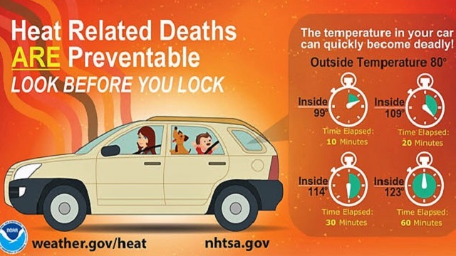
The upper ridge migrates slowly eastward through mid-week as it generally weakens. The weakening of the upper ridge means we’ll stay warm but avoid any excessive heat concerns. But with highs still in the lower 90s, be sure to look out for pets and kids by checking the back seat of your car before locking up to run into a store or business.
For the latter half of the week, a fairly strong short wave moving out of the northern Rockies will dampen the ridge over the Southeast US as it moves across the Great Lakes. This leaves weak ridging elongated across the southern tier of the US for the latter half of the week with no appreciable change in the air mass. So showers/storms remain in the forecast along with highs mainly in the lower 90s.
Looking out into voodoo country, the GFS maintains the westerlies well to our north as the air mass remains mostly unchanged. The GFS becomes bullish on developing a ridge along the eastern slopes of the Rockies by July first.
BEACH FORECAST: No affects from the Gulf system or Bud on the beautfiul beaches of Alabama and Northwest Florida. Click here to see the AlabamaWx Beach Forecast Center page.
WEATHERBRAINS: Don’t forget you can listen to our weekly 90 minute netcast anytime on the web, or on iTunes. This is the show all about weather featuring many familiar voices, including our meteorologists here at ABC 33/40.
The Weather Xtreme Video will be on a one-a-day schedule this week as James takes a well earned vacation. I’ll be filling in today on ABC 3340 at 5 and 10 pm for Charles Daniel who will be subbing for James this week. Due to commitments, there is some question as to whether or not I’ll have a video on Monday and Tuesday morning, but I will post a discussion. Enjoy your day, and Godspeed.
-Brian-
.
Category: Alabama's Weather, ALL POSTS, Weather Xtreme Videos
About the Author (Author Profile)
Brian Peters is one of the television meteorologists at ABC3340 in Birmingham and a retired NWS Warning Coordination Meteorologist. He handles the weekend Weather Xtreme Videos and forecast discussion and is the Webmaster for the popular WeatherBrains podcast.Subscribe
If you enjoyed this article, subscribe to receive more just like it.


