A Quick Check At 7:05PM; Damage Reports So Far Today In Central Alabama
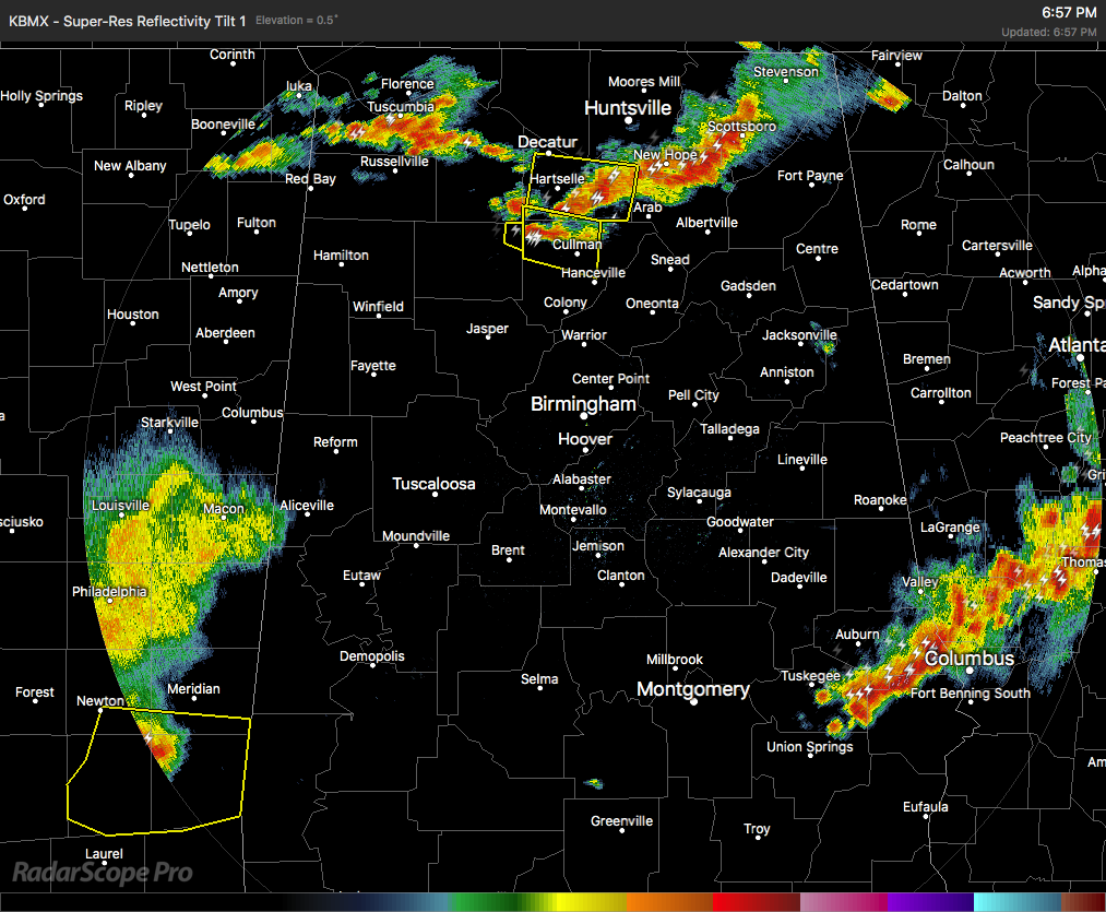
Radar check at 6:57 PM continues to show several severe thunderstorm out there across portions of North and Central Alabama, and as I type, parts of Lee and Russell counties just went under a severe thunderstorm warning.
The good news is that those storms in the southeastern parts of the area should be out of the sate and into Georgia within the next hour or so. The bad news is that there are more showers and thunderstorms in Mississippi the will push over into the southwestern parts of the area within the next hour or so.
More strong to severe storms are located over the northern parts of the area stretching pretty much over the Tennessee River from the Mississippi state line to the Georgia state line.
All of these storms are producing gusty winds, dangerous cloud-to-ground lightning, very heavy rainfall, and some hail at times.
The window for strong to severe storms continue on until at least 10:00 PM tonight, but several storms will linger on through the late night and into the overnight hours. Some storms could be strong but the likelihood of severe storms will be really low for the overnight.
Here are some damage reports from across Central Alabama as of 7:00 PM…
Vernon (Lamar Co.): Small greenhouse overturned and few branches reported down by estimated 40-50 mph winds.
Coloma (Cherokee Co.): Tree and powerlines blocking road at highway 9 and county road 18. Winds estimated 30-40 mph with 26 mph measured at EOC.
Tennala (Cherokee Co.): Multiple trees down on residential driveways. winds estimated 40-50 mph per radar. 26 mph gust measured at EOC.
Yates Dam (Tallapoosa Co.): Tree down on roadway at Greenwood Road and Gammils Store Road. Wind estimated 40-50 mph per radar.
Penton (Chambers Co.): 911 dispatch center reports multiple power lines down in various areas.
Jackson’s Gap (Tallapoosa Co.): Tree down at Eagle Creek Road and Crouch Road.
Dadeville (Tallapoosa Co.): Trees down on Dudleyville Road and McKelvey Street.
UAB Campus (Jefferson Co.): A few trees down, at least one vehicle damaged near UAB campus in Birmingham.
Category: Alabama's Weather, ALL POSTS
About the Author (Author Profile)
Scott Martin is an operational meteorologist, professional graphic artist, musician, husband, and father. Not only is Scott a member of the National Weather Association, but he is also the Central Alabama Chapter of the NWA president. Scott is also the co-founder of Racecast Weather, which provides forecasts for many racing series across the USA. He also supplies forecasts for the BassMaster Elite Series events including the BassMaster Classic.Subscribe
If you enjoyed this article, subscribe to receive more just like it.


