

Early Afternoon Update: More Storms on the Way
It has been a wet and stormy Saturday morning across North/Central Alabama as several MCSs ride east along a stalled frontal boundary across the Southeast. There have been numerous reports of tree damage and power line damage the last 24 hours, and we are in store for some more storms as we continue through our Saturday afternoon and evening. Also, a NWS survey team has confirmed an EF-0 tornado along HWY 80 in far Northeast Winston Co. The damage was minor (a few downed trees and some tin/roofing peeled back on a couple of barns/sheds).
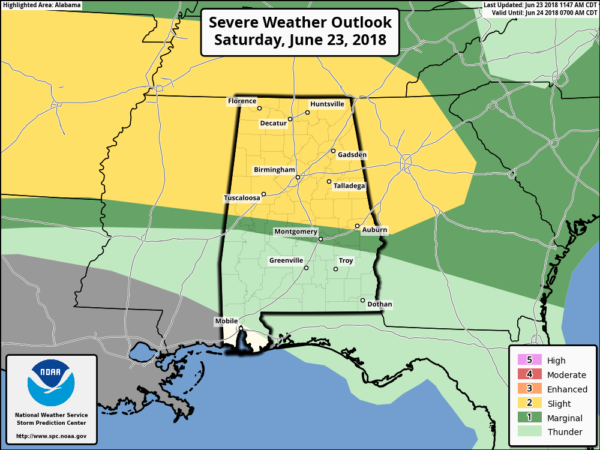
The SPC continues to have much of North/Central Alabama outlined in a “slight risk” (level 2 out of 5) for severe storms the rest of today.
There are additional shower and thunderstorms moving through Marion and Winston counties which are producing a lot of lightning and more heavy rainfall. These storms are not severe, but of course we will monitor them as it will not take much for storms to once again reach severe limits with damaging wind gusts.
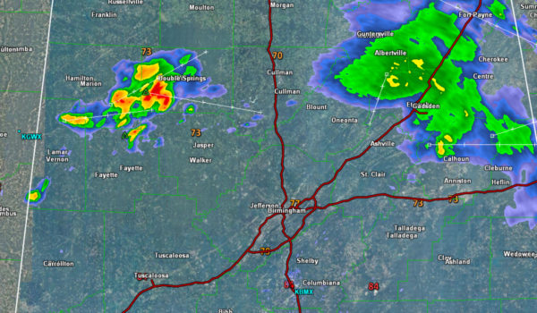
Additional development is expected this afternoon in the I-22/US-280 Corridor from Jasper to Birmingham to Alex City around 2-4 p.m.. Like all storms in this unstable environment, they will need to be monitored for the threat of gusty winds.
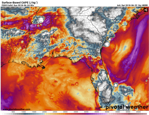
Moving through the afternoon, forecast model output from the RAP is pointing to 3000-4000 J/KG of SB CAPE building into at least our far western/southwestern counties by late this afternoon. However, the RAP is currently not doing a good job of taking into account the large subsidence zone that’s currently in place behind the initial outflow boundaries from this morning convection.
It’s also unclear if we’ll have enough lift from those outflow boundaries moving in from the west to trigger those storms. Below the HRRR shows CAPE values approaching 2500 J/KG which will be more than sufficient for fueling additional showers and storms.
The HRRR and other mesoscale guidance is starting to hint at more development following almost no development a few hours ago. Therefore, much uncertainty remains in today’s severe weather forecast. Damaging straight-line winds will remain the greatest hazard.
With the different possible scenarios, later this afternoon and evening, it appears another complex of storms could develop to our west and push across Central Alabama from west to east in the 5-11 PM time frame. Of course, this may not happen, but there just seems to be enough instability and uplift in place where we should see some storm development and these storms will be associated with an area of high moisture and strong instability, so severe weather is possible along with heavy rain and dangerous lightning. We must all stay weather aware the rest of the day, and check the blog for the latest updates.
Flash flooding will remain a concern as well for the rest of the day too, especially in locations which have received heavy rainfall already today.
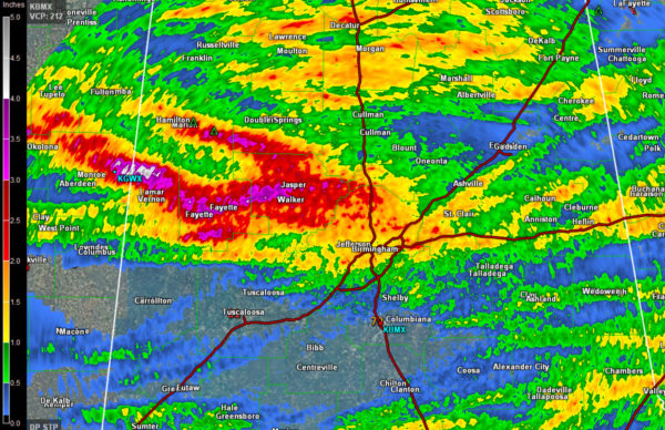
Estimated rainfall totals from radar since 1am this morning shows a few spots are showing estimates of 2-5 inches in Jefferson, Walker, Fayette, and Winston Counties. An additional 2-3 inches of rain will be possible with any storms which may develop.
Category: Alabama's Weather, ALL POSTS
About the Author (Author Profile)
Macon, Georgia Television Chief Meteorologist, Birmingham native, and long time Contributor on AlabamaWX. Stormchaser. I did not choose Weather, it chose Me. College Football Fanatic. @Ryan_StinnetSubscribe
If you enjoyed this article, subscribe to receive more just like it.


