

Tornado Watch Issued For North Alabama Until 2:00 AM
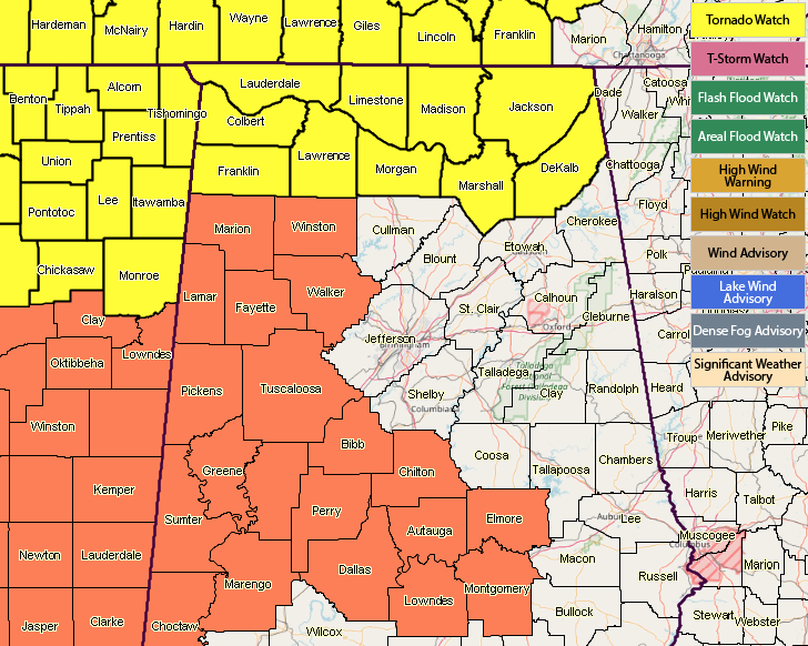
The Storm Prediction Center in conjunction with NWS Huntsville has issued a Tornado Watch until 2:00 AM Saturday for these counties in North Alabama: Colbert, DeKalb, Franklin, Jackson, Lauderdale, Lawrence, Limestone, Madison, Marshall, and Morgan.
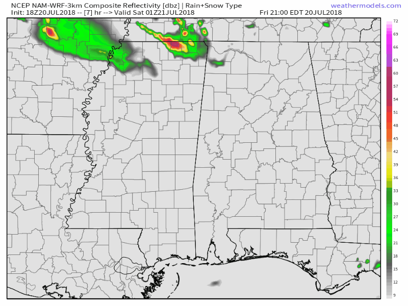
A surface boundary is currently located to our northwest stretching from the southern parts of Illinois and Indiana to the southwest into southeastern Missouri and northern Arkansas. As this pushes to the southeast throughout the evening and into the overnight hours, this is where convective thunderstorms will form. At this point, there is only a couple of thunderstorms in the southeastern parts of Missouri, but they are severe with the possibility of wind gusts up to 60 MPH.
There will be enough shear for the formation of supercells with the possibility of bowing segments with stronger wind gusts. There will be plenty of instability, and you add in the stronger shear values, a few tornadoes and damaging hail will be possible.
The main window for strong to severe storms look to be from 8:00 PM tonight through 5:00 AM Saturday morning. Once the line of storms move into the state, they will stay rather strong for a while, feeding off of the available instability. As the line progresses southward through Central Alabama during the overnight hours, that instability will begin to diminish some and storms will weaken. With that being said, there is a risk for severe storms throughout all of North and Central Alabama.
Storms should be affecting the Tuscaloosa, Birmingham, and Anniston areas somewhere between 11:00 PM to 2:00 AM. For points north of that, the window will be from as early as 8:00 PM through 2:00 AM. For points south of that, the window will be from 12:00 AM through 6:00 AM.
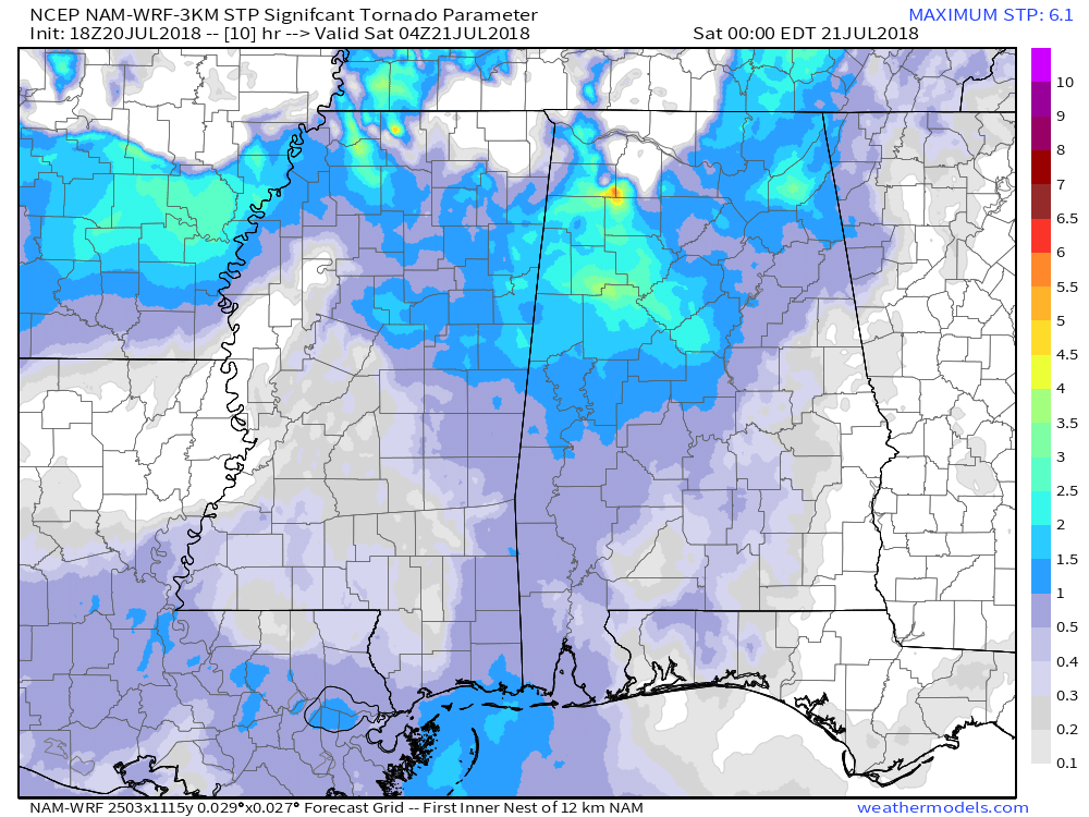
At this point, it looks like the higher chances for a few tornadoes will be over the northwest quarter of the area, including such locations as Birmingham, Tuscaloosa, Fayette, Hamilton, Double Springs, and Jasper.
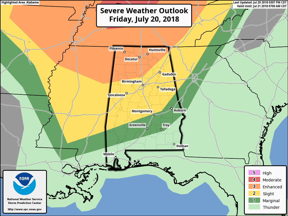
Locations in the Enhanced Risk for severe storms will have the higher chances of damaging winds up to 70-80 MPH, damaging hail, and a few tornadoes. The Slight Risk area will have slightly lower chances for damaging winds up to 70 MPH, some small hail, and a brief spin-up tornado or two. The Marginal Risk area will have a chance of some isolated damaging wind gusts up to 60 MPH.
We’ll continue to have updates through the evening and into the overnight hours. Go ahead and have your plans of action ready to go, along with your supplies and NOAA Weather Radio.
Category: Alabama's Weather, ALL POSTS
About the Author (Author Profile)
Scott Martin is an operational meteorologist, professional graphic artist, musician, husband, and father. Not only is Scott a member of the National Weather Association, but he is also the Central Alabama Chapter of the NWA president. Scott is also the co-founder of Racecast Weather, which provides forecasts for many racing series across the USA. He also supplies forecasts for the BassMaster Elite Series events including the BassMaster Classic.Subscribe
If you enjoyed this article, subscribe to receive more just like it.


