

Storms Now Firing in Arkansas, Warnings Issued
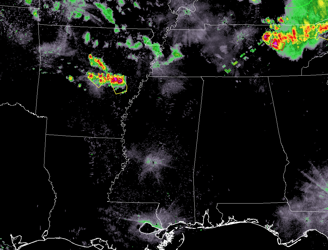
As we take a look at the radar composite for the southeastern United States, we can see that all of the state of Alabama is still dry as we make it into the 9 o’clock hour. Much of the activity is located well north of the state in the northeastern parts of Tennessee and up into Kentucky, Indiana, and Ohio. Several severe thunderstorm warnings are currently in effect, along with a tornado warning, in Tennessee. These storms are moving to the southeast and will stay out of North/Central Alabama.
Looking more back to our northwest in the east-central parts of Arkansas, we see that several storms have fired up within the last hour and have reached severe limits. This is just ahead of the surface boundary that is making its way southeastward down the trough in place. This is where our main threat for stronger to severe storms will come from tonight.
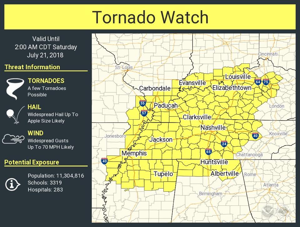
A Tornado Watch continues in effect for nearly all of the North Alabama counties until 2:00 AM Saturday, with the exception of Cullman County. Main threats will be from damaging thunderstorm wind gusts, with a smaller threat of hail and an isolated tornado or two.
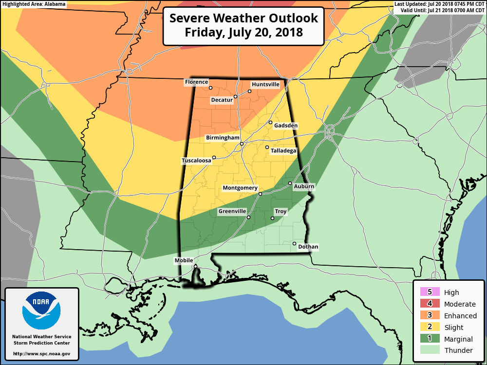
SPC continues an Enhanced Risk for severe storms for much of North Alabama including points north of a line from Fayette to Warrior to Ider. South of that line is a Slight Risk that stretches down to Lowndesboro to Tallassee to Rock Mills. The rest of Central Alabama is defined in a Marginal Risk.
MESOSCALE DISCUSSION
The storms are firing ahead of a cold front south of a low over southern Illinois, along the southern edge of a 500 millibar jet. It is also in an area of deep moisture convergence.
The upper level jet is producing substantial bulk wind shear that will support organized storms.
The thermodynamics over eastern Arkansas and northern Mississippi is very high. This high instability trails off a bit into northern Alabama, but is still substantial. CAPE values are between 3,000-4,500 joules/kg over Northwest Alabama. Downdraft CAPE is very high, indicating the potential for damaging winds is high.
The SIgnificant Tornado Parameter is very high over southeastern Arkansas and northwestern Mississippi (over 4). Elevated values extend into Northwest Alabama, presenting the possibility of a tornado or two.
Mid-level lapse rates are very high meaning once an updraft gets started, it will intensify rapidly. We have already seen that in the newly developed Arkansas storms.
All this indicates that widespread severe storms should continue to push southeastward across northern mississippi and into West Alabama. The mesoscale models are no help to us at this time. The radar will be our friend along with this mesoscale analysis.
BE PREPARED TONIGHT
Have a reliable way to get warnings tonight. Take severe thunderstorm warnings very seriously. Be in a substantial structure BEFORE the storms arrive and stay out of the reach of trees that could fall.
Category: Alabama's Weather, ALL POSTS
About the Author (Author Profile)
Scott Martin is an operational meteorologist, professional graphic artist, musician, husband, and father. Not only is Scott a member of the National Weather Association, but he is also the Central Alabama Chapter of the NWA president. Scott is also the co-founder of Racecast Weather, which provides forecasts for many racing series across the USA. He also supplies forecasts for the BassMaster Elite Series events including the BassMaster Classic.Subscribe
If you enjoyed this article, subscribe to receive more just like it.


