Looking At The Situation For Later Today And Tonight
FORECAST NOT GETTING ANY EASIER: An unusual pattern for July continues over the eastern U.S., with strong jet dynamics coming into play thanks to a deep upper trough digging southward. The strong wind fields aloft, along with the usual summer instability, will keep the risk of severe storms in the forecast through tonight. And, as we have pointed out in recent days, these “northwest flow” events are challenging to forecast. Computer models are of little use, and we don’t have much experience since almost all of our organized severe weather days in Alabama are “southwest flow” events.
THIS MORNING: The forecast storms finally showed up after midnight last night and early this morning (better late than never), and they are still rolling through parts of Alabama. Two batches of storms are moving southeastward, one over the western counties, and one over the eastern counties. Birmingham and Tuscaloosa are in the middle so far with no rain as of 8am CT.
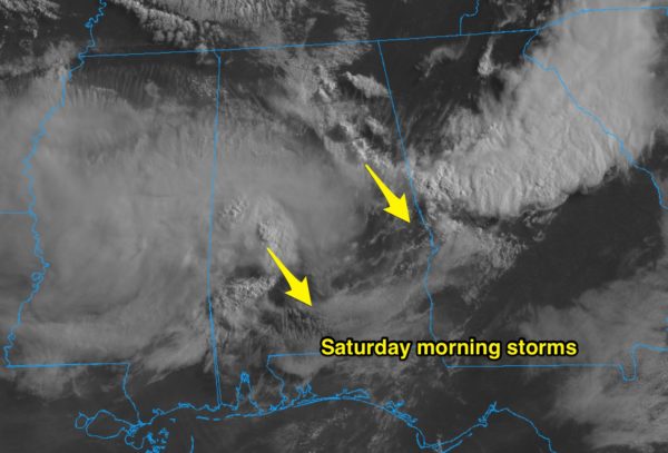
Most of these storms will be out of the area by mid-morning, and we expect a lull in the action through the midday/early afternoon hours.
LATE THIS AFTERNOON/TONIGHT: More storms will likely develop later. Here is the current thinking…
*Scattered strong to severe thunderstorms will develop in the unstable environment across parts of Alabama late this afternoon and tonight; the main window for severe storms will come from 4:00 p.m. until 12:00 midnight.
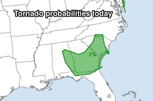
*The greatest risk of severe storms will be in areas south and east of Birmingham. SPC has revised their outlook for today… the standard “slight risk” (level 2/5) covers much of East-Central, Southeast, and South Alabama. There is lower end “marginal risk” (level 1/5) as far north as Tuscaloosa, Birmingham, and Decatur. No organized severe storms are forecast for Northwest Alabama.

*Where storms do develop, they will be capable of producing damaging winds and large hail.
*An isolated tornado can’t be ruled out over parts of East and Southeast Alabama in the broad zone from Anniston to Dothan.
*Not everyone will see a storm; they will tend to be rather cellular in nature, and not linear, most likely.
*Be sure and pay attention to both tornado AND severe thunderstorm warning if they are needed.
*We don’t expect any widespread flooding issues, but heavier storms could put down one inch of rain in a short amount of time.
Tomorrow will be calmer; while a few showers are possible, there is only a marginal risk of severe storms for just the southeast corner of Alabama around Dothan.
Keep an eye on the blog for updates through the day!!
Category: Alabama's Weather, ALL POSTS, Severe Weather
About the Author (Author Profile)
James Spann is one of the most recognized and trusted television meteorologists in the industry. He holds the AMS CCM designation and television seals from the AMS and NWA. He is a past winner of the Broadcast Meteorologist of the Year from both professional organizations.Subscribe
If you enjoyed this article, subscribe to receive more just like it.


