Numerous Showers/Storms into Early Tuesday
We’re waking up to a mixture of clouds and clear spots with the radar active with scattered showers moving eastward through Central Alabama. The showers remained small so spots getting rain were not getting much. The exception was over South Alabama where larger clusters were producing a bit more rain. We should see a good deal of clouds again today with showers and storms numerous at times. Temperatures will remain a bit below seasonal averages with highs mainly in the middle and upper 80s.

Another fairly strong upper trough will move across Iowa on Monday bringing a continuation of unsettled weather for us with showers and storms expected to be numerous once again. SPC has outlined a marginal risk area for isolated severe weather which catches the northwest corner of Alabama. While severe weather should be primarily damaging wind, as the strong trough weakens as it moves east there is a small risk for large hail and an isolated tornado.

Tuesday the trough moves by us bringing a cold front into and through much of the Southeast US. This is going to change our air mass with much drier air filtering into the area Tuesday afternoon and early Wednesday. Highs both days should be in the middle 80s, but the most noticeable feature will be the lower dew points as values fall into the lower 60s.
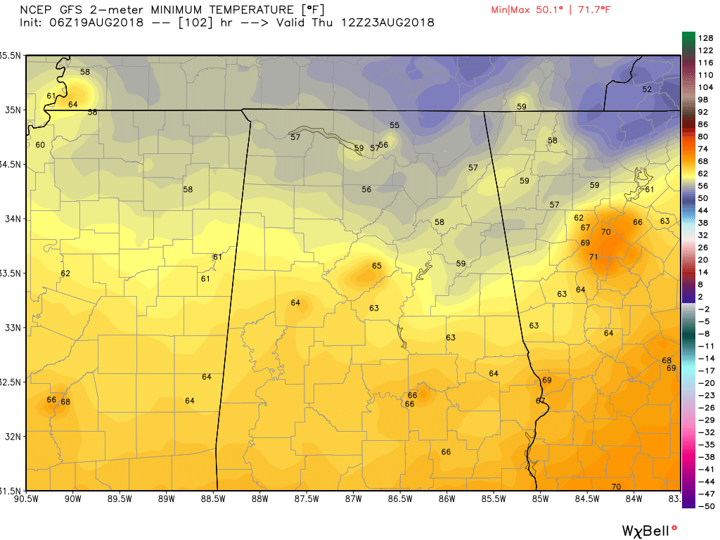
Several fast moving troughs will help to reinforce the trough along the East Coast Wednesday and Thursday. This keeps us dry with precipitable water values falling below 1 inch. This opens the doors for some rather coolish – compared to the rest of August – morning lows dropping into the lower and middle 60s with the potential for upper 50s across the Tennessee River Valley.
Upper level ridging comes into play on Friday and the upper ridge builds stronger into Saturday and Sunday. Moisture values begin to come back once again as dew points are forecast to climb back into the upper 60s. This should be enough for a few isolated showers driven mainly by afternoon heating as highs push back toward the 90-degree mark.
Rainfall for the next several days should range from about a half inch to one inch with perhaps slightly higher amounts across South Alabama.
Looking out into voodoo country, it does not look like we’ll escape some August heat as the GFS is pretty bullish on a strong upper ridge. The ridge is strong over the Ohio and Tennessee River Valleys by August 28th. It grows even stronger as we move into early September, but the upper ridge moves into the Four Corners area by September 3rd with a trough along the East Coast beating back the heat for the Southeast US.
Tropics: The Atlantic Basin is once again free on any areas of concern with nothing expected to develop for the next several days.
Beach Forecast: Click here to see the AlabamaWx Beach Forecast Center page.
WeatherBrians: Don’t forget you can listen to our weekly 90 minute netcast anytime on the web, or on iTunes. This is the show all about weather featuring many familiar voices including our meteorologists here at ABC 33/40.
Be sure to stay dry today. James Spann will have the next Weather Xtreme Video here around 7 am or so on Monday. Godspeed.
-Brian-

Category: Alabama's Weather, ALL POSTS, Weather Xtreme Videos
About the Author (Author Profile)
Brian Peters is one of the television meteorologists at ABC3340 in Birmingham and a retired NWS Warning Coordination Meteorologist. He handles the weekend Weather Xtreme Videos and forecast discussion and is the Webmaster for the popular WeatherBrains podcast.Subscribe
If you enjoyed this article, subscribe to receive more just like it.


