A Few Scattered Storms Over The Weekend
RADAR CHECK: The majority of the showers and thunderstorms across Alabama this afternoon are down across the southern half of the state; showers are pretty isolated over the northern counties. The sky is generally cloudy, and temperatures are mostly in the 80s. Scattered showers will fade away later tonight.
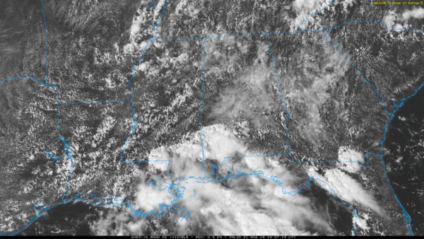
THE WEEKEND: An upper ridge will slowly strengthen, so at this point we project fairly typical weather for the first of September; partly sunny days, fair nights, and a few widely scattered afternoon showers and thunderstorms. Chance of any one spot getting wet tomorrow is 30/40 percent, dropping to 25 percent Sunday afternoon.
FOOTBALL WEATHER: For high school games tonight, the weather will be warm and humid with just an outside risk of a shower during the first half. Temperatures will fall from the low 80s into the upper 70s.
Tomorrow, Auburn takes on Washington in Atlanta in Mercedes Benz Stadium (2:30p CT kickoff). Outside the domed stadium, afternoon temperatures will be in the 87-90 degree range with the risk of a shower or thunderstorm.
Then, tomorow evening, Alabama will take on Louisville in Orlando (7:00p CT kickoff). The weather will be humid, and a shower or thunderstorm is possible during the game, mainly during the first half. Kickoff temperature in the low 80s, falling into the upper 70s by the final whistle.
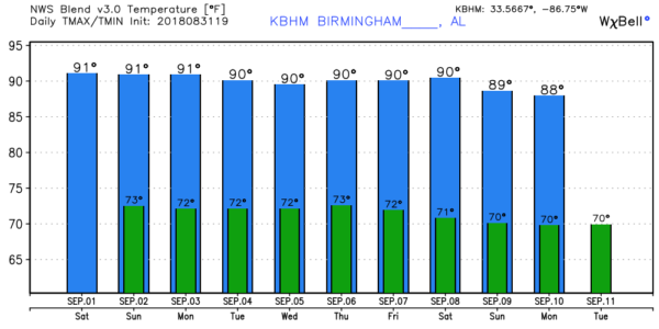
NEXT WEEK: The upper ridge holds, and for North/Central Alabama highs each day will be in the 88-91 degree range with just a few isolated afternoon showers. Partly sunny days, mostly fair nights. There is a chance rain and storms will increase over South Alabama over the latter half of the week due to a tropical wave in the Gulf of Mexico… see the ABC 33/40 Weather Xtreme video for maps, graphics, and more details.
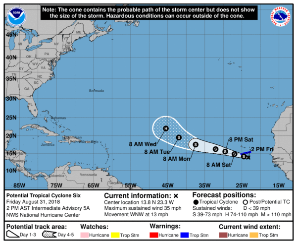
TROPICS: A disturbance near the Cape Verde Islands is expected to become Tropical Storm Florence tonight… it will move over the far eastern Atlantic, far from land over the weekend and early next week. A good chance it becomes a hurricane by the middle of next week, and as it gains latitude there is a decent chance it recurves harmlessly into the Atlantic with no impact to North America. But, that is not totally carved in stone… we will keep an eye on it.
A tropical wave over Hispaniola will move toward the Gulf of Mexico next week, but NHC gives it only a 10 percent chance of development over the next five days due to harsh environmental conditions. It could bring some rain to the Gulf Coast over the latter half of the week, however… we will keep an eye on it.
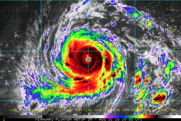
And, over in the western Pacific, Super Typhoon Jebi is packing sustained winds of around 170 mph… it will impact Japan early next week, but it will be weakening by then. Still, potential for a high impact event with a number of population centers across the projected path.
BEACH FORECAST: Click here to see the AlabamaWx Beach Forecast Center page.
WEATHER BRAINS: Don’t forget you can listen to our weekly 90 minute netcast anytime on the web, or on iTunes. This is the show all about weather featuring many familiar voices, including our meteorologists here at ABC 33/40.
CONNECT: You can find me on all of the major social networks…
Facebook
Twitter
Instagram
Pinterest
Snapchat: spannwx
I had a great time today visiting with the third graders at Cherokee Bend Elementary in Mountain Brook… be looking for them on the Pepsi KIDCAM today at 5:00 on ABC 33/40 News! Look for my next Weather Xtreme video here Monday morning by 7:00 a.m… Brian Peters will have the video updates tomorrow and Sunday. Enjoy the weekend!
Category: Alabama's Weather, ALL POSTS, Weather Xtreme Videos
About the Author (Author Profile)
James Spann is one of the most recognized and trusted television meteorologists in the industry. He holds the AMS CCM designation and television seals from the AMS and NWA. He is a past winner of the Broadcast Meteorologist of the Year from both professional organizations.Subscribe
If you enjoyed this article, subscribe to receive more just like it.


