Late Evening Notes on Our Tropical Storm-To-Be
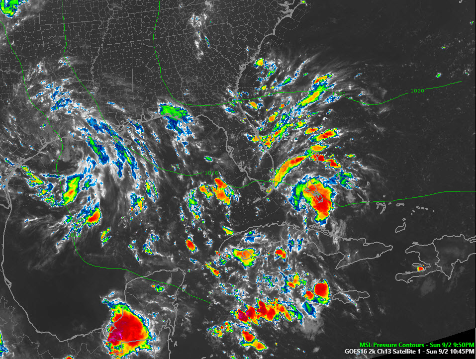
Convection is increasing and there appears to be some banding on infrared satellite pictures this evening in the vicinity of the southern Bahamas around Potential Tropical Cyclone Seven.
But there is still no closed circulation, hence still no tropical depression.
But the system is in an area of low wind shear and it will be traveling over really warm water over the next 24 hours, so some strengthening is possible.
It likely will strengthen steadily when it is over the southeastern Gulf of Mexico, and it is expected to become a tropical storm by Monday evening. It should strengthen steadily in its trek over the Gulf of Mexico and is expected to be a strong tropical storm with sustained winds of 60 mph by late Tuesday evening or Wednesday morning when the center reaches the coast between Dauphin Island and Lake Charles.
Almost all of the intensity models keep it below hurricane strength, but a more westward track toward the Central Louisiana coast might give it time to strengthen further.
The first Air Force Reserve Hurricane Hunter flight should be on station investigating the system by 10 a.m. CDT on Monday. It may be a depression crossing the Florida Keys by then.
The first guidance of our main models is coming in now, and the 12km NAM shows the center passing about 70 miles south of Gulf Shores Tuesday evening. This is slightly to the right of the official forecast track and inside the error envelope. This track would take the center to near the Louisiana/Mississippi border and would bring tropical storm force winds close to if not over coastal Alabama.
If any case, winds approaching tropical storm force or higher will reach the Alabama Coast by late Tuesday afternoon. A tropical storm watch is in effect for Mobile and Baldwin Counties westward to just east of Morgan City, Louisiana.
LABOR DAY WEATHER: DAUPHIN ISLAND TO PANAMA CITY
There may be some rain across during the day, but I think most of the day will be dry. Winds will be east at 10-15 mph, gusting to 20 mph.
COASTAL IMPACTS…
…WIND
Winds will approach tropical storm force (greater than 39 mph) by late Tuesday afternoon across Mobile and Baldwin Counties. From Pensacola to Panama City, winds will average 10-15 with gusts to 20 mph Tuesday and Tuesday night.
…RAIN
Rain and storms will become likely all along the coast b early afternoon Tuesday and will increase in intensity through the evening hours. Heavy rainfall of 1-3 inches will affect the Northwest Florida coast and 3-5 inches will affect the Alabama and Mississippi coasts into Southeast Louisiana.
…STORM SURGE
Surge of 2-4 feet possible on the Mississippi/Alabama coast. 1-2 feet of surge is expected along the coast west of Destin to the Alabama State Line and west of the mouth of the Mississippi River along the Louisiana coast.
…TORNADOES
Tornadoes are possible to the right of the center, although with a west-northwestward moving system, the tornado threat seems to be less pronounced in my experience. I cannot back that up with research, but it seems like storms like Elena and Erin produced fewer tornadoes.
We will be monitoring the system carefully as it becomes a tropical depression and likely a tropical storm on Monday. Stay with AlabamaWX for the latest on the storm.
About the Author (Author Profile)
Bill Murray is the President of The Weather Factory. He is the site's official weather historian and a weekend forecaster. He also anchors the site's severe weather coverage. Bill Murray is the proud holder of National Weather Association Digital Seal #0001 @wxhistorianSubscribe
If you enjoyed this article, subscribe to receive more just like it.


