Tropical Trouble For The Gulf Coast
EYES ON THE GULF: We have a quiet Labor day morning across the great state of Alabama; generally dry with just a few showers near the Gulf Coast. The northern half of the state will enjoy a good supply of sunshine today with only isolated showers this afternoon; scattered showers and storms will be more numerous over the southern counties…. the high will be pretty close to 90 degrees.
The weather for the rest of the week will all depend on the track of Tropical Storm Gordon in the Gulf of Mexico… here is the latest…
GORDON FORMS: NHC has just upgraded the system over the Upper Florida Keys to Tropical Storm Gordon, with sustained winds of 45 mph.
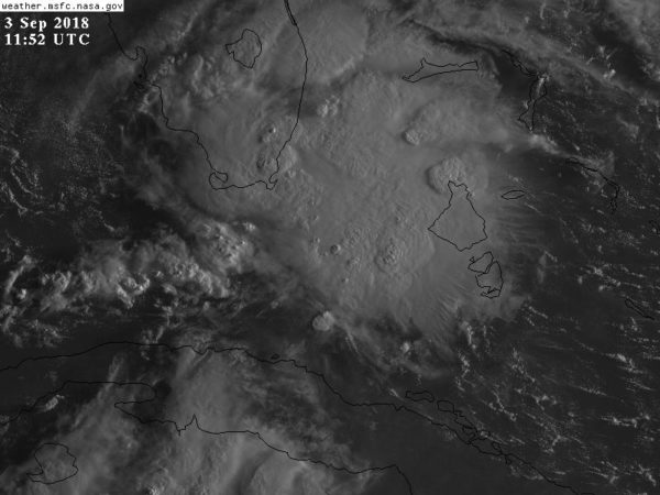
FORECAST TRACK: NHC forecasts Gordon to move into Southeast Louisiana late tomorrow night or early Wednesday with winds of 60 mph…

A tropical storm warning is in effect for the Alabama Gulf Coast, and points west to Morgan City, Louisiana.
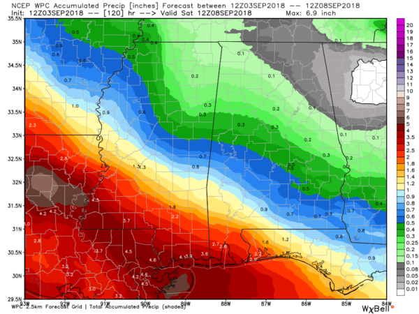
COASTAL IMPACT: The primary threat is from heavy rain, flooding, and rip currents along the coast. Flash flood watches are up for Mobile and Baldwin counties in Alabama… and westward across South Mississippi and Southeast Louisiana. Rain amounts of 2-4 inches are likely, with isolated heavier amounts. Most of the rain directly associated with the tropical system will come late tomorrow afternoon, tomorrow night, and into Wednesday morning.

We could see a few wind gusts to 50 mph, but winds will be generally in the 25-35 mph range on the Alabama Gulf Coast tomorrow night into Wednesday morning.
A few isolated tornadoes or waterspouts are possible as the system nears the coast, but the overall threat is low, and SPC does not have a severe weather threat identified in their outlooks for now.
The weather will improve greatly on the Gulf Coast Thursday and Friday.
For those with a trip planned to Gulf Shores or Orange Beach this week asking if they need to cancel, just remember different people have a different reason for beach trips. We can’t answer that question, but understand it will be rather wet and breezy there tomorrow night into Wednesday. The rest of the week will feature routine September weather with a mix of sun and scattered storms.
INLAND IMPACT: There will be a sharp gradient in rain across Alabama with this system; the heaviest rain will come over Southwest Alabama… mostly south of a line from Butler to Monroeville to Florala. Some rain is possible Wednesday and Thursday over the western third of the state, but heavier totals will be west of Alabama. This week will be relatively dry for North and East Alabama with only isolated showers.
UNCERTAINTY: Once the system has formed with a well defined low level center, forecast confidence will be higher, so watch for potential changes today as the system becomes better organized.
FRIDAY AND THE WEEKEND: Friday and Saturday look relatively dry with a good supply of sunshine and only isolated showers. Afternoon storms could be a little more numerous Sunday as a surface front approaches from the north. Afternoon highs will remain generally in the 87-90 degree range over the weekend.
NEXT WEEK: Seems like the chance of showers and storms will be higher over North Alabama Monday and Tuesday with a slow moving surface front just to the north… then there is a chance we see drier air toward the end of next week with the GFS showing an upper trough over the eastern third of the nation. But, the European model isn’t on board with that idea. And, keep in mind the first good push of cool air of the fall season usually arrives in Alabama in late September.

TROPICAL STORM FLORENCE: Florence is in the Atlantic, far from land, with sustained winds of 60 mph…

While Florence certainly could recurve into the open Atlantic, the European global model (which is pretty reliable) shows a blocking high north of the system, and pushes it toward the East Coast of the U.S. in 10 days or so. Our friends on the Atlantic Coast need to keep an eye on this one.
And, a new wave is emerging off the coast of Africa; just a low chance of development there this week. See the Weather Xtreme video for maps, graphics, and more details.
BEACH FORECAST: Click here to see the AlabamaWx Beach Forecast Center page.
WEATHER BRAINS: Don’t forget you can listen to our weekly 90 minute netcast anytime on the web, or on iTunes. This is the show all about weather featuring many familiar voices, including our meteorologists here at ABC 33/40.
CONNECT: You can find me on all of the major social networks…
Facebook
Twitter
Instagram
Pinterest
Snapchat: spannwx
Look for the next Weather Xtreme video here by 4:00 this afternoon… Happy Labor Day!
Category: Alabama's Weather, ALL POSTS, Weather Xtreme Videos
About the Author (Author Profile)
James Spann is one of the most recognized and trusted television meteorologists in the industry. He holds the AMS CCM designation and television seals from the AMS and NWA. He is a past winner of the Broadcast Meteorologist of the Year from both professional organizations.Subscribe
If you enjoyed this article, subscribe to receive more just like it.


