Gordon Getting Close To The Coast
GORDON TO MAKE LANDFALL TONIGHT: Tropical Storm Gordon in the Gulf of Mexico, south of Orange Beach, continues to move steadily toward the coast this afternoon. For the northern half of the state, we have scattered showers and storms over the western counties, mainly west of I-65… they are moving to the west/northwest.
Here is the latest impact information on Gordon…
TRACK/INTENSITY: Gordon is expected to make landfall tonight just west of Dauphin Island, near the Alabama/Mississippi border, as a category one hurricane. For now, Gordon packing sustained winds of 70 mph, and the pressure right at 1000 mb. Some strengthening is still possible before it reaches the coast tonight.

Widespread rain is now on the coast from Gulf Shores all the way eastward to Apalachicola; the large rain mass will cover all of Mobile and Baldwin counties by evening.
WARNINGS: A Hurricane Warning is in effect from the mouth of the Pearl River to the Alabama-Florida Border, including all of the Alabama Gulf Coast. A Storm Surge Warning is in effect from Shell Beach to Dauphin Island.
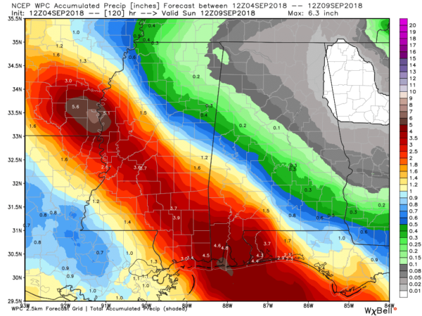
COASTAL IMPACT: Rain amounts of 3-6 inches are likely across Southwest Alabama, and a flash flood watch remains in effect for Mobile, Baldwin, Washington, and Escambia counties. A storm surge of 3 to 5 feet is forecast for Mobile County/Dauphin Island… 2 to 4 feet for Baldwin County (Fort Morgan, Gulf Shores, Orange Beach).
A few isolated tornadoes and waterspouts are possible on the Alabama coast tonight…

Sustained winds of 30-50 mph are likely on the Alabama coast tonight, with potential gusts to hurricane force (75 mph).
INLAND IMPACT: The heaviest rain tonight and tomorrow from Gordon in Alabama will be south of a line from Butler to Monroeville to Florala. Showers are a good bet over the western half of the state tomorrow, as far north as Haleyville, but amounts should be fairly light north of I-20.
Rain amounts north and east of Birmingham will be very light and spotty through mid-week despite Gordon passing to the west.
We should also mention that SPC does have a “marginal risk” (level 1/5) up tomorrow for parts of West Alabama… we will watch radar closely for any tropical showers that try and rotate; an isolated tornado can’t be totally ruled out.

THURSDAY/FRIDAY: We will maintain the chance of scattered showers and thunderstorms Thursday, mainly over the western half of the state, then Friday looks generally dry with only isolated afternoon showers. After highs in the 80s through mid-week; we will see a maximum temperature close to 90 Friday afternoon.
THE ALABAMA WEEKEND: Not much change Saturday; partly sunny and hot with only isolated afternoon showers and a high near 90. Then, on Sunday, a surface front will drift down into Tennessee, and scattered showers and storms should become more numerous over the northern half of the state. Sunday’s high will be in the upper 80s for most communities.
NEXT WEEK: We will maintain the chance of scattered showers and storms for at least the first half of the week, but the Tennessee front will stall and dissipate north of Alabama. No sign of any real cool air; remember… the first good cool air push of the season usually arrives here in late September. See the Weather Xtreme video for maps, graphics, and more details.

FLORENCE IS NOW A HURRICANE: Hurricane Florence is packing sustained winds of 75 mph, in the open Atlantic far from land. It remains to be seen if the system will recurve into the Atlantic, or bend westward toward North America. One way of another it is a long way out there and just something to watch for now.

And, a wave in the far eastern Atlantic should become Tropical Storm Helene over the next few days… it is moving west/northwest. Again, way to early to know the final destination.
BEACH FORECAST: Click here to see the AlabamaWx Beach Forecast Center page.
WEATHER BRAINS: Don’t forget you can listen to our weekly 90 minute netcast anytime on the web, or on iTunes. This is the show all about weather featuring many familiar voices, including our meteorologists here at ABC 33/40. We will produce this week’s show tonight at 8:30 CT… you can watch it live here.
CONNECT: You can find me on all of the major social networks…
Facebook
Twitter
Instagram
Pinterest
Snapchat: spannwx
I had a great time today visiting with the 5th graders at Greenville Middle School in Butler County… be looking for them on the Pepsi KIDCAM today at 5:00 on ABC 33/40 News! The next Weather Xtreme video will be posted here by 7:00 a.m. tomorrow…
Category: Alabama's Weather, ALL POSTS, Weather Xtreme Videos
About the Author (Author Profile)
James Spann is one of the most recognized and trusted television meteorologists in the industry. He holds the AMS CCM designation and television seals from the AMS and NWA. He is a past winner of the Broadcast Meteorologist of the Year from both professional organizations.Subscribe
If you enjoyed this article, subscribe to receive more just like it.


