Rain Mainly For West Alabama Today
GORDON INLAND AND WEAKENING: Gordon made landfall near the Alabama/Mississippi border last night as a strong tropical storm with 70 mph winds; the center this morning is over South Mississippi… it continues to move northwest. The rain shield associated with the storm is over the western half of Alabama, generally west of I-65. Rain will continue over West Alabama through the morning, with little, if any, rain for the eastern counties of the state.
SPC maintains a “marginal risk” of severe storms for parts of West and Southwest Alabama today… generally south of a line from Gordo to Selma to Greenville…
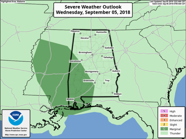
There is a low end risk of a few small, isolated, short lived tornadoes over West Alabama today, on the eastern periphery of the circulation of Gordon. But, we have had no tornado warnings overnight, and the overall threat is low. Still, we will watch radar trends.
A flash flood watch remains in effect for Southwest Alabama this morning. Further inland, rain amounts today over West-Central Alabama will be in the one inch range, but we don’t expect any flooding issues.
TOMORROW: The remnant circulation of Gordon will arc through Arkansas and Missouri, and Alabama will remain in a fairly moist airmass. So, we will have the risk of scattered showers and thunderstorms, especially over the western side of the state where moisture levels are higher. We will experience more clouds than sun, and the high will be in the 80s.
FRIDAY AND THE WEEKEND: These two days look hot and mostly dry as the ridge rebuilds; afternoon showers are possible, but they should be pretty isolated. Highs will be in the 88-91 degree range. Scattered afternoon showers and storms will be a little more numerous over North Alabama Sunday as a surface front creeps southward into Tennessee. The high Sunday will be in the upper 80s.
FOOTBALL WEATHER: For the high school games Friday night, just a small risk of a shower during the first half, otherwise mostly fair and very warm with temperatures falling though the 80s during the games.
Alabama hosts Arkansas State Saturday afternoon in Tuscaloosa at Bryant-Denny Stadium (2:30p CT kickoff); the sky will be partly to mostly sunny with just a small risk of a shower during the game. Kickoff temperature will be close to 90 degrees, falling back into the 80s by the fourth quarter.
Auburn will host Alabama State Saturday evening at Jordan-Hare Stadium (6:30p CT kickoff)… the sky will be mostly fair with only a slight risk of a shower during the first half. Temperatures will fall from near 86 at kickoff, into the upper 70s by the final whistle.
UAB travels to Conway, South Carolina to take on Coastal Carolina Saturday evening (6:00p CT kickoff)… a shower or storm is possible during the first half of the game, otherwise it will be warm and humid with temperatures falling through the 80s during the game.
NEXT WEEK: Scattered showers and storms will remain possible on most days next week with a warm, moist airmass in place. Otherwise, partly sunny days with highs in the upper 80s. See the Weather Xtreme video for maps, graphics, and more details.

TROPICS: A new wave over the eastern Atlantic is expected to become Tropical Storm Helene over the next few days. No way of knowing if this will threaten the Lesser Antilles at this point. Florence is a hurricane in the middle of the Atlantic with 105 mph winds. It is far from land, and it still remains to be seen if this recurves, or bends back to the west thanks to a blocking high developing north of the system. Everyone on the East Coast of the U.S. will need to keep an eye on this one in coming days.

BEACH FORECAST: Click here to see the AlabamaWx Beach Forecast Center page.
WEATHER BRAINS: Don’t forget you can listen to our weekly 90 minute netcast anytime on the web, or on iTunes. This is the show all about weather featuring many familiar voices, including our meteorologists here at ABC 33/40.
CONNECT: You can find me on all of the major social networks…
Facebook
Twitter
Instagram
Pinterest
Snapchat: spannwx
I have a weather program this morning at Taylorville Primary School in Tuscaloosa… look for the next Weather Xtreme video here by 4:00 this afternoon. Enjoy the day!
Category: Alabama's Weather, ALL POSTS, Weather Xtreme Videos
About the Author (Author Profile)
James Spann is one of the most recognized and trusted television meteorologists in the industry. He holds the AMS CCM designation and television seals from the AMS and NWA. He is a past winner of the Broadcast Meteorologist of the Year from both professional organizations.Subscribe
If you enjoyed this article, subscribe to receive more just like it.


