Scattered Showers Tomorrow; Florence Now A Category Four
RADAR CHECK: Most of the showers on radar this afternoon are across the eastern and southern counties of Alabama… generally south of I-59. They are moving northeast, and a few could linger into the late night hours ahead of a stalled front over the northwest part of the state. Temperatures are only in the 70s across North Alabama this afternoon; the average high for September 10 at Birmingham is 87.
TOMORROW THROUGH FRIDAY: A few scattered showers and storms are possible across the state tomorrow, but we trend drier and hotter Wednesday through Friday as we get into subsidence on the far periphery of Hurricane Florence. Look for partly to mostly sunny conditions on those three days with only widely scattered afternoon showers; chance of any one spot getting wet is only in the 20-25 percent range. Highs will be in the upper 80s Wednesday, and close to 90 Thursday and Friday.
THE ALABAMA WEEKEND: It looks hot and mostly dry with only isolated showers Saturday and Sunday; a good supply of sunshine both days with highs around 90 degrees. The big rain shield associated with Hurricane Florence will stay well to the northeast of Alabama.
NEXT WEEK: The first half of the week looks calm with only isolated showers… moisture levels will rise, however, over the latter half of the week with better chances of showers and storms.

FLORENCE: Florence is now a major, category four hurricane with winds of 130 mph…
There is increasing confidence that Florence will be a large and extremely dangerous hurricane at landfall, regardless of its exact intensity.

Key Messages:
1. A life-threatening storm surge is likely along portions of the coastlines of South Carolina, North Carolina, and Virginia, and a Storm Surge Watch will likely be issued for some of these areas by Tuesday morning. All interests from South Carolina into the mid-Atlantic region should ensure they have their hurricane plan in place and follow any advice given by local officials.
Evacuations begin tomorrow along most of the North Carolina and South Carolina coastline.
2. Life-threatening freshwater flooding is likely from a prolonged and exceptionally heavy rainfall event, which may extend inland over the Carolinas and Mid Atlantic for hundreds of miles as Florence is expected to slow down as it approaches the coast and moves inland.

3. Damaging hurricane-force winds are likely along portions of the coasts of South Carolina and North Carolina, and a Hurricane Watch will likely be issued by Tuesday morning. Damaging winds could also spread well inland into portions of the Carolinas and Virginia.
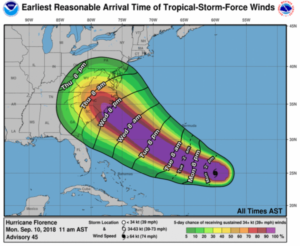
4. Large swells affecting Bermuda and portions of the U.S. East Coast will continue this week, resulting in life-threatening surf and rip currents.
5. It is important not to focus on the exact forecast track as average NHC errors at days 4 and 5 are about 140 and 180 nautical miles, respectively, and dangerous hazards will extend well away from the center.
ISAAC: Hurricane Isaac is expected to pass across the Lesser Antilles Thursday, and into the Caribbean Friday. Shear is expected to weaken the system to tropical storm strength over the weekend; still too early to know if this will impact the Gulf of Mexico. Most members of the European model ensemble bring it into Central America with little northward motion.

HELENE: Hurricane Helene is in the far eastern Atlantic; it will turn north in a day or so, and is no threat to land.

INVEST 95: A disturbance will move into the Southern Gulf of Mexico tomorrow; NHC gives it a 50 percent chance of development over the next five days. For now it looks like the main impact will be heavy rain potential for the Texas Gulf Coast later this week. For now odds are low that this impacts the Central Gulf Coast.
See the Weather Xtreme video for maps, graphics, and more details.
BEACH FORECAST: Click here to see the AlabamaWx Beach Forecast Center page.
WEATHER BRAINS: Don’t forget you can listen to our weekly 90 minute netcast anytime on the web, or on iTunes. This is the show all about weather featuring many familiar voices, including our meteorologists here at ABC 33/40.
CONNECT: You can find me on all of the major social networks…
Facebook
Twitter
Instagram
Pinterest
Snapchat: spannwx
Look for the next Weather Xtreme video here by 7:00 a.m. tomorrow…
Category: Alabama's Weather, ALL POSTS, Weather Xtreme Videos
About the Author (Author Profile)
James Spann is one of the most recognized and trusted television meteorologists in the industry. He holds the AMS CCM designation and television seals from the AMS and NWA. He is a past winner of the Broadcast Meteorologist of the Year from both professional organizations.Subscribe
If you enjoyed this article, subscribe to receive more just like it.


