Scattered Showers Later Today; Watching Florence
A FEW SHOWERS: We will maintain the chance of a few widely scattered showers and thunderstorms across Alabama this afternoon and this evening, otherwise today will feature a mix of sun and clouds with a high in the mid to upper 80s.
Our weather trends hotter and drier tomorrow through the weekend as we get in the zone of the sinking air around the periphery of Hurricane Florence. Chance of any one spot getting tomorrow is 20/30 percent, then dropping to 10/20 percent Friday through Sunday. Partly to mostly sunny days, fair nights, and highs around 90 degrees.
FOOTBALL WEATHER: Auburn hosts LSU Saturday afternoon (2:30p CT kickoff) at Jordan-Hare Stadium… the sky will be mostly sunny with a kickoff temperature near 90 degrees, falling into the upper 80s by the fourth quarter. The chance of a shower is not zero, but very low.
Alabama travels to Oxford to take on Ole Miss Saturday evening (6:00p CT kickoff)… the sky will be mostly clear. The temperature will fall from near 88 at kickoff, into the low 80s by the final whistle.
UAB hosts Tulane Saturday at Legion Field (12:00 noon CT kickoff)… the sky will be mostly with temperatures rising from 87 at kickoff, to near 90 by the fourth quarter. Just a very small risk of a shower during the game.
FLORENCE: Hurricane Florence is packing sustained winds of 130 mph, and will be approaching the coast of the Carolinas late tomorrow night into Friday morning.
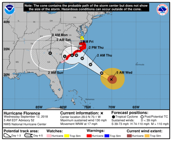
There is great uncertainty beyond 48 hours as the steering currents collapse. Most of the global models now suggest Florence will stall, and drift southwest down the South Carolina coast, possibly even reaching the Georgia coast over the weekend before turning inland. NHC has adjusted their forecast track southward, and they say more southward adjustments will likely be needed later today.
Due to the slow motion of the system, extremely heavy rain is likely over parts of the Carolinas, with a high risk of serious freshwater flooding.

Here are the key messages from NHC…
1. A life-threatening storm surge is now highly likely along portions of the coastlines of South Carolina and North Carolina, and a Storm Surge Warning is in effect for a portion of this area. All interests from South Carolina into the mid-Atlantic region should complete preparations and follow any advice given by local officials.
2. Life-threatening, catastrophic flash flooding and significant river flooding is likely over portions of the Carolinas and Mid-Atlantic states from late this week into early next week, as Florence is expected to slow down as it approaches the coast and moves inland.
3. Damaging hurricane-force winds are likely along portions of the coasts of South Carolina and North Carolina, and a Hurricane Warning is in effect. Strong winds could also spread inland into portions of the Carolinas.
4. Large swells affecting Bermuda and portions of the U.S. East Coast will continue this week, resulting in life-threatening surf and rip currents.
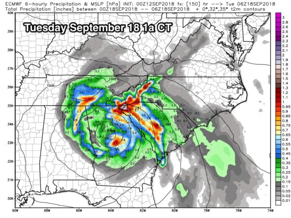
ANY IMPACT ON ALABAMA? The European global model shows a track through Georgia Sunday and Monday; even with that scenario Alabama would stay on the drier, west side of the circulation, but it could be close enough for some rain over the eastern counties of the state early next week. But again, uncertainty is very high, and there is a chance East Alabama will see little rain. The chance of rain (as a direct result of Florence) for the western and southern counties of the state is very low.
ISAAC: This tropical storm is expected to pass through the Leeward Islands tomorrow, and into the Caribbean Friday. The good news is that shear will take a big toll, and NHC is now forecasting Isaac to dissipate across the Caribbean by Sunday with no impact on the Gulf of Mexico.
HELENE: The hurricane in the far eastern Atlantic is moving north, and is no threat to land.
INVEST 95L: A tropical wave in the southern Gulf of Mexico could become a tropical depression over the next 24 hours; it is headed for the Texas coast with potential for heavy rain. This will no impact Alabama or the Central Gulf Coast.
ON THIS DATE IN 1979: Hurricane Frederic made landfall at about 10 p.m. CDT, passing over Dauphin Island and crossed the coastline near the Alabama/Mississippi border. A wind gust of 145 miles per hour was measured on equipment atop the Dauphin Island Bridge. The bridge was destroyed. A wind gust of 139 mph was measured at the Dauphin Island Sea Lab before the equipment failed. A storm surge of 12 feet was observed in Gulf Shores. Nearly all structures within 200 yards of the Alabama coast were destroyed. There were only two fatalities as a direct result of Frederic. Total damages were 2.3 billion dollars, making Frederic the most expensive hurricane ever to strike the United States up to that point.
BEACH FORECAST: Click here to see the AlabamaWx Beach Forecast Center page.
WEATHER BRAINS: Don’t forget you can listen to our weekly 90 minute netcast anytime on the web, or on iTunes. This is the show all about weather featuring many familiar voices, including our meteorologists here at ABC 33/40.
CONNECT: You can find me on all of the major social networks…
Facebook
Twitter
Instagram
Pinterest
Snapchat: spannwx
Look for the next Weather Xtreme video here by 4:00 this afternoon… enjoy the day…
Category: Alabama's Weather, ALL POSTS, Weather Xtreme Videos
About the Author (Author Profile)
James Spann is one of the most recognized and trusted television meteorologists in the industry. He holds the AMS CCM designation and television seals from the AMS and NWA. He is a past winner of the Broadcast Meteorologist of the Year from both professional organizations.Subscribe
If you enjoyed this article, subscribe to receive more just like it.


