Hot/Dry Weather For Alabama; Florence On The Coast
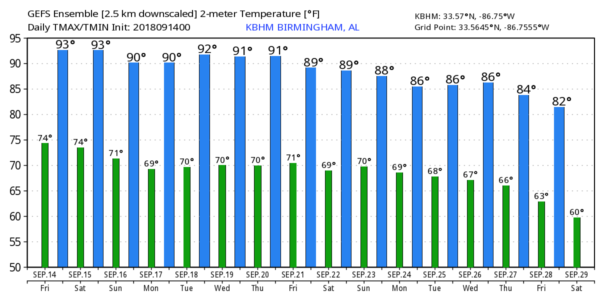
DRY DAYS: Alabama will settle into a hot, dry pattern for the next five to seven days with few, if any afternoon showers or thunderstorms. We are forecasting mostly sunny days and fair nights through the weekend with highs in the low 90s, and lows in the low 70s. The chance of any one community seeing a shower is so small we won’t mention it in the forecast.
FOOTBALL WEATHER: Mostly fair and warm for tonight’s high school games with temperatures falling through the 80s.
Auburn hosts LSU tomorrow afternoon (2:30p CT kickoff) at Jordan-Hare Stadium… the sky will be mostly sunny with a kickoff temperature near 90 degrees, falling into the upper 80s by the fourth quarter.
Alabama travels to Oxford to take on Ole Miss Saturday evening (6:00p CT kickoff)… the sky will be mostly clear. The temperature will fall from near 88 at kickoff, into the low 80s by the final whistle.
UAB hosts Tulane Saturday at Legion Field (12:00 noon CT kickoff)… the sky will be mostly with temperatures rising from 87 at kickoff, to near 90 by the fourth quarter.
NEXT WEEK: Hot, dry weather continues for the first half of the week; we will introduce the chance of widely scattered afternoon showers Thursday and Friday, but certainly no widespread rain. Highs through the week will be in the upper 80s and low 90s as the upper ridge holds across the Southeast U.S. See the Weather Xtreme video for maps, graphics, and more details.
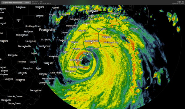
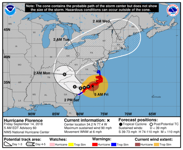
FLORENCE ON THE COAST: Florence is making landfall on the North Carolina coast near Wilmington early this morning as a category one hurricane with sustained winds of 90 mph. Severe storm surge and inland freshwater flooding will continue today; additional rain amounts of 20″ are likely in places that have already received one foot.
Florence will drift slowly through South Carolina over the weekend with more heavy rain before recurving into the westerlies.
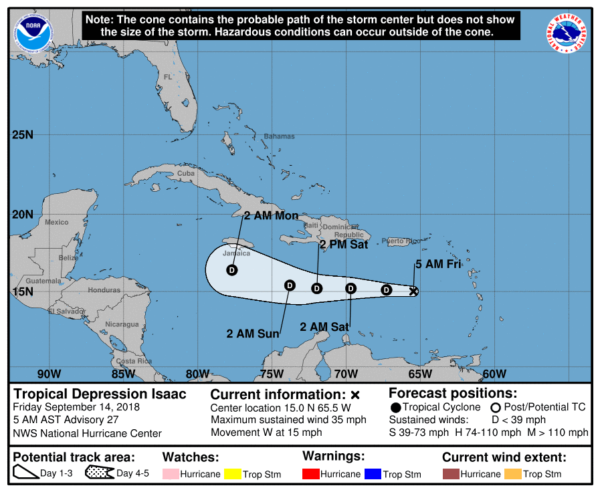
REST OF THE TROPICS: Invest 95L will move into South Texas this morning with potential for heavy rain; looks like it won’t be developing into a depression. Helene and Joyce are tropical storms in the far eastern Atlantic; no threat to land (although Helene will be approaching Ireland by Monday night of next week as a post-tropical system). And, Isaac is a weak depression in the Caribbean; a good chance it won’t survive due to strong shear and dry air.
There are no systems threatening the Central Gulf Coast for the next week.
BEACH FORECAST: Click here to see the AlabamaWx Beach Forecast Center page.
WEATHER BRAINS: Don’t forget you can listen to our weekly 90 minute netcast anytime on the web, or on iTunes. This is the show all about weather featuring many familiar voices, including our meteorologists here at ABC 33/40.
CONNECT: You can find me on all of the major social networks…
Facebook
Twitter
Instagram
Pinterest
Snapchat: spannwx
I have a weather program this morning at DeArmanville Elementary in Calhoun County this morning… Look for the next Weather Xtreme video here by 4:00 this afternoon… enjoy the day!
Category: Alabama's Weather, ALL POSTS, Weather Xtreme Videos
About the Author (Author Profile)
James Spann is one of the most recognized and trusted television meteorologists in the industry. He holds the AMS CCM designation and television seals from the AMS and NWA. He is a past winner of the Broadcast Meteorologist of the Year from both professional organizations.Subscribe
If you enjoyed this article, subscribe to receive more just like it.


