An Early Morning Look at Hurricane Michael
Not much change in the status of Hurricane Michael overnight or the thinking about its eventual track or intensity.
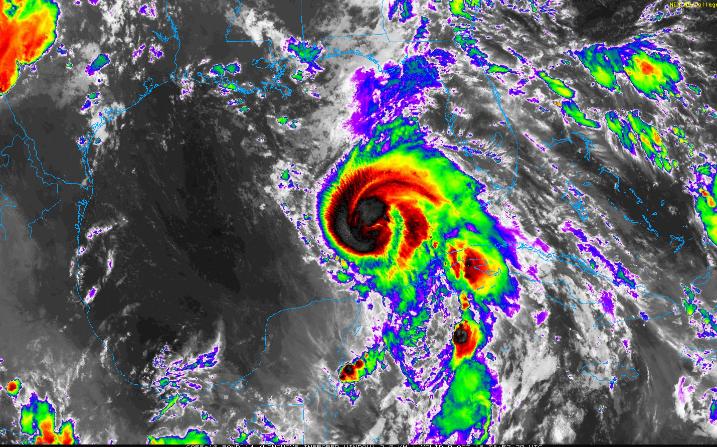
The center of Hurricane Michael is 460 miles south of Panama City, Florida this morning. Top winds are 90 mph. It is moving to the north-northwest at 12 mph. This course is expected to continue to a turn to the north and north-northeast this afternoon and tonight. This will bring the center to the coast somewhere between Fort Walton and Steinhatchee, Florida in the Florida Big Bend area.
There is good agreement between the GFS and European based on the overnight runs. The operational runs carry the center to the coast near Panama City. The GFS depicts a 948 mb hurricane landing around 4-6 p.m. Wednesday. The Euro shows a 953 mb hurricane landing at Panama City around 6-8 p.m. Wednesday. So the official NHC track is closely aligned with this output but a little faster, calling for landfall around noon – 2 p.m.
The hurricane stopped intensifying during the evening, feeling the effects of 20 knots of shear and some dry air entrainment. But the shear is expected to relax later today and the hurricane is over warm water, so the hurricane should resume strengthening, making if a strong category two or low-end category three hurricane at landfall.
The last fix from the Air Force plane was just before midnight. The central pressure on that last fix was 974 mb. Another plane will be enroute soon to monitor the storm.
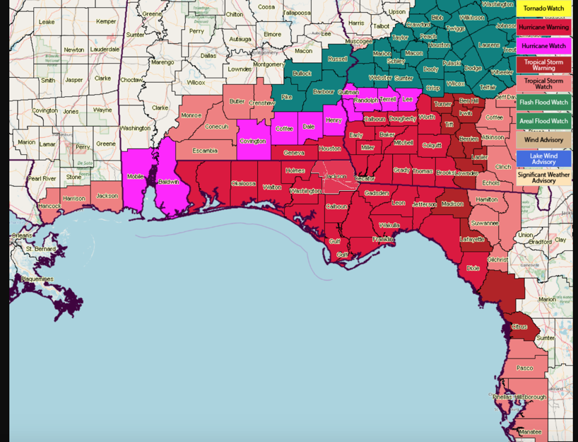
CURRENT WARNINGS
Here is a map of the current watches and warnings.
CENTRAL ALABAMA TODAY
It will be breezy at times this afternoon across Central and South Alabama. In the I-20 Corridor, winds will average 10-15 mph, so you will get some feel that there is a hurricane in the Gulf. Skies will become partly to mostly cloudy at times. It should be mainly dry. There could be a few showers late tonight over eastern sections of the state. It will still be warm and humid with highs in the middle 80s.
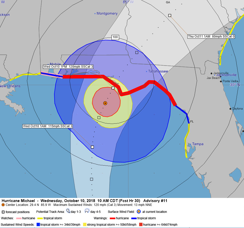
Wind field at 10 a.m. Wednesday morning according to the official NHC forecast
IMPACTS
The core of the hurricane will start coming onshore Wednesday morning between midnight and 6 a.m. with heavy rain and tropical storm force winds from the Big Bend area westward to Pensacola. Conditions will gradually worsen during the day, with strong tropical storm force winds (>58 mph) arriving by late morning and overspreading the coast between Destin and St. Marks. Hurricane conditions could arrive as early as noon along the coast and will impact an area from the beaches of 30A to St. Marks. Any deviation in the track to the left or right will shift these conditions west or east accordingly.
A storm surge of 8-12 feet is expected from Indian Pass to Cedar Key in the Florida Big Bend area. Indian Pass is south of St. Joe. This will mean a devastating storm surge for St. George Island and Apalachicola and other locations around the Apalachee Bay. From Destin to Panama City, the storm surge will be 6-9 feet and from the Alabama/Florida line to Destin, expect 2-4 feet. There will be significant surge flooding for the beach communities along 30A.
Heavy rains of 7-10 inches will impact areas near and to the east of the track up into southern Georgia. Flash flood watches are in effect. Rainfall of 2-5 inches will impact the rest of the Florida Panhandle up into extreme Southeast Alabama. Areas southeast of a line from Auburn to Evergreen will see 1-3 inches of rain, but for Central Alabama, almost none.
Most of the tornado threat should come on Wednesday, impacting the Florida Panhandle, North Florida, extreme Southeast Alabama and South Georgia.
PAY CLOSE ATTENTION TO LOCAL OFFICIALS
Residents, visitors and property owners along the coast from Mobile and Baldwin County in Alabama all the way to the Tampa Bay area should listen to local emergency officials and heed their advice. Small changes in the track will result in very different impacts from wind, storm surge and flooding rains.
About the Author (Author Profile)
Bill Murray is the President of The Weather Factory. He is the site's official weather historian and a weekend forecaster. He also anchors the site's severe weather coverage. Bill Murray is the proud holder of National Weather Association Digital Seal #0001 @wxhistorianSubscribe
If you enjoyed this article, subscribe to receive more just like it.


