Michael Down to 955 Millibars; Could Become a Cat Four Before Landfall
Hurricane Michael is now a major hurricane late this afternoon. It was upgraded to category three status on the 4 p.m. advisory when its maximum sustained winds reached 120 mph.
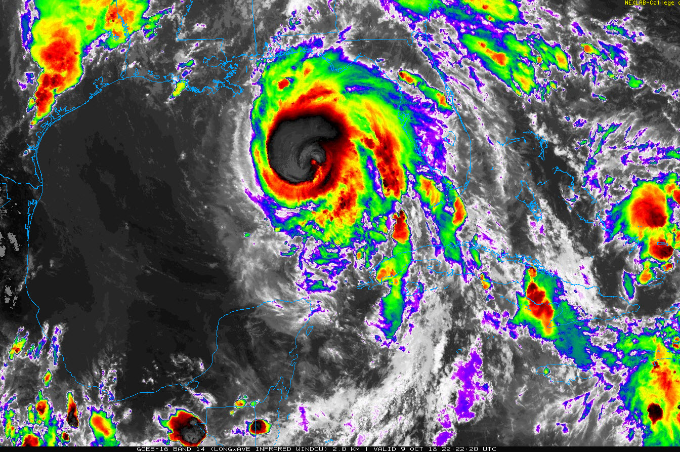
The central pressure in the storm has fallen to 955 or 954 millibars according to the Air Force plane making its second pass through the eye of the storm for this mission.
The central pressure has fallen 20 millibars since 4 a.m. That is right on the precipice of rapid intensiifcation, which is characterized as a pressure drop of 1.5 millibars per hour.
The storm’s satellite presentation continues to pulse in and out. The storm is fairly symmetrical and it appears to have good outflow. This combined with the fact that it is over 28C water tells us that continued steady strengthening is likely until landfall. Michael may become a category four hurricane before landfall. Category 4 is 130-156 mph.
Here is a visible satellite image, one of the last of the day:
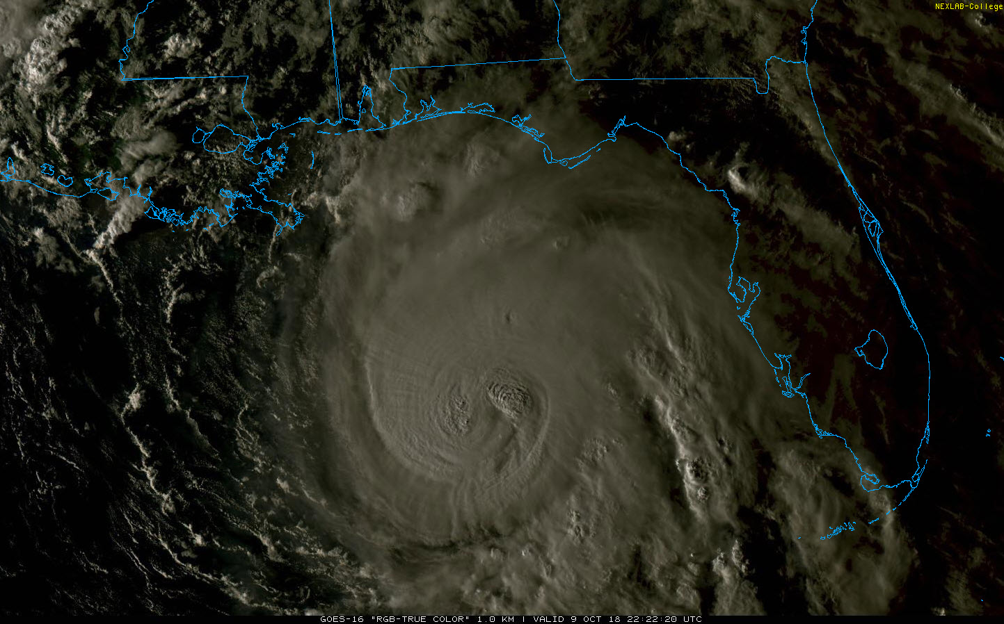
The center of Michael is now 285 miles south of Panama City, moving just left of north at 12 mph. Confidence is high that the hurricane will continue on a northward course before turning to the northeast ahead of a strong trough approaching from the west.
Squalls will begin early this evening along the coast. Preparations should be rushed to completion in the hurricane warning area, which extends from the Alabama/Florida border to Suwanee River in Florida.
Tropical storm force winds will begin reaching the coast in the Cape San Blas/Port St. Joe area after midnight tonight, gradually overspreading the coast between Mobile Bay and Suwanee River, Florida. Strong tropical storm force winds of 58 mph or greater will begin reaching the coast by mid-morning from Panama City to Apalachicola and gradually pverspreading the coast between Destin and St. Marks.
Hurricane force winds will reach the coast by early afternoon and affect areas from Seaside to Cape San Blas. Those hurricane force winds will push inland nearly as far as Albany. Strong tropical force winds will reach parts of Henry, Geneva, and Houston counties in Alabama. The time frame for tropical storm force winds over Southeast Alabama will be between 10 a.m. and 5 p.m.
Folks as far west as Baldwin County up through Escambia, Conecuh and Butler counties may experience tropical storm conditions. Here are the current watches and warnings in effect. Hurricane warnings and watches have priority over tropical storm warnings and watches. A flash flood effect is also in effect for parts of South Alabama.
Here is the expected wind field based on the official forecast track at landfall, which is forecast to be about 3 p.m. CDT tomorrow.
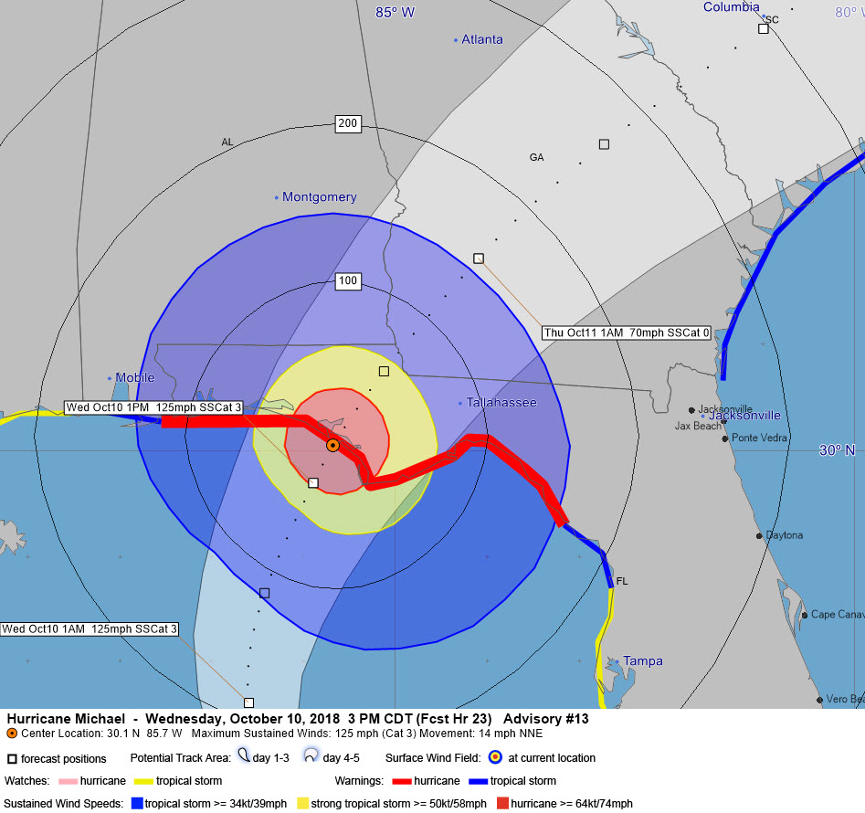
I still fear that the center could deviate 50 miles to the west or east of this forecast point, which would create significantly different impacts. A more westerly track could bring hurricane conditions to areas from Penscalosa to Destin, and a more easterly track could produce hurricane conditions as far east of St. Marks and deal a devastating blow to Tallahassee and all its trees. Those are things to watch out for.
Conditions should improve from the west starting around sundown. Tropical storm conditions should end in Destin by 7 p.m. and Panama City by 10 p.m. By midnight, strong winds should have diminished all along the coast, but will still be raging over Georgia as the storm will slowly weaken over land.
A powerful storm surge will overspread the coast from the Okaloosa/Walton County line near Sandestin to the Anclote River north fo Tampa. A catastrophic surge will overspread the coast near the center track and to the east of it. That looks like it will be from Mexico Beach south of Panama City to Keaton Beach. Areas from the Okaloosa/Walton County line to Mexico Beach, including all of 30A and Panama City will experience 6-9 feet of surge. Areas south of Keaton Beach to Cedar Key will also experience 6-9 feet of surge.
Surge values are already running 2 feet above normal all along the coast from Pascagoula across the Alabama and Florida Coast to Cedar Key.
INTERESTING NOTE
Earlier today, when two planes were flying penetrations through the eye, the crews of the two aircraft could actually see each other! The Hurricane Hunters, both Air Force and NOAA, are providing an invaluable service to the affected areas.
FREQUENT UPDATES FROM HERE ON OUT
James, Scott and I will have frequent updates on the storm and its impacts for coastal areas as well as Central Alabama.
About the Author (Author Profile)
Bill Murray is the President of The Weather Factory. He is the site's official weather historian and a weekend forecaster. He also anchors the site's severe weather coverage. Bill Murray is the proud holder of National Weather Association Digital Seal #0001 @wxhistorianSubscribe
If you enjoyed this article, subscribe to receive more just like it.


