

Fine Fall Weather Through The Weekend
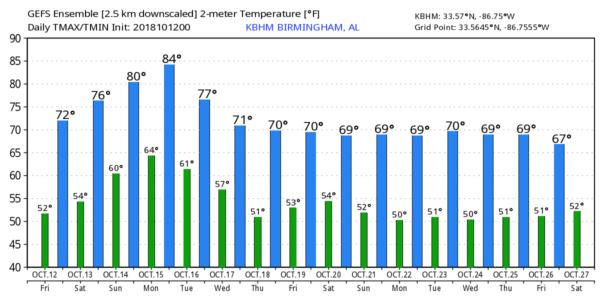
DRY AIR: We are starting the day down in the 40s for most North Alabama communities… our coolest morning since late April. Today will feature a cloudless sky along with a high at or just over 70 degrees this afternoon. A cobalt blue sky with low humidity. Tonight will be clear and cool with a low between 48 and 52.
THE WEEKEND: We stay dry through most of the weekend; expect a partly sunny sky tomorrow and Sunday… the high tomorrow will be in the low to mid 70s, followed by low 80s Sunday. A few showers could reach far Northwest Alabama Sunday night.
FOOTBALL WEATHER: For the high school games tonight, the weather will be clear and cool with temperatures falling from the mid 60s at kickoff into the upper 50s by the final whistle.
Tomorrow Auburn hosts Tennessee at Jordan-Hare Stadium (11a CT kickoff)… the sky will be partly sunny with temperatures rising from near 70 at kickoff, into the mid 70s by the fourth quarter.
Alabama will host Missouri tomorrow evening (6p CT kickoff) at Bryant-Denny Stadium; expect a clear sky with temperatures falling from 74 at kickoff into the upper 60s by the end of the game.
UAB will travel to Houston to play Rice Saturday (12 Noon CT kickoff)… the sky will be partly sunny with 82 at kickoff, and mid 80s by the second half.
RACE WEEKEND: A great weekend for NASCAR fans coming into Talladega; lots of sunshine each day through Sunday with pleasant temperatures. Look for a high in the low 70s today, mid 70s tomorrow, and upper 70s Sunday. Mornings will be cool with lows in the 40s and 50s.
NATIONAL SHRIMP FESTIVAL: Sunny days, fair nights at Gulf Shores through Sunday with highs around 80 and lows in the upper 50s and low 60s. Could not be any better.
NEXT WEEK: Rain is likely at times over the far northwest corner of the state Monday and Tuesday, but for the rest of the state we expect only widely scattered showers. Wednesday through Friday will be dry with pleasant days and cool nights… see the Weather Xtreme video for maps, graphics, and more details.
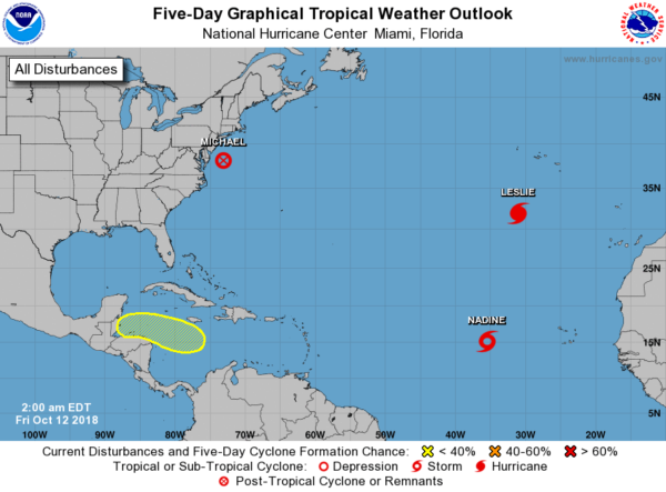
TROPICS: Michael is now post-tropical, and moving away from the U.S. Hurricane Leslie and Tropical Storm Nadine are in the eastern Atlantic and no threat to land. And, a disturbance in the Caribbean will most likely move into Central America in a few days; NHC gives it only a 30 percent chance of development over the next five days.
BEACH FORECAST: Click here to see the AlabamaWx Beach Forecast Center page.
WEATHER BRAINS: Don’t forget you can listen to our weekly 90 minute show anytime on your favorite podcast app. This is the show all about weather featuring many familiar voices, including our meteorologists here at ABC 33/40.
CONNECT: You can find me on all of the major social networks…
Facebook
Twitter
Instagram
Pinterest
Snapchat: spannwx
Look for the next Weather Xtreme video here by 4:00 this afternoon… enjoy the day!
Category: Alabama's Weather, ALL POSTS, Weather Xtreme Videos
About the Author (Author Profile)
James Spann is one of the most recognized and trusted television meteorologists in the industry. He holds the AMS CCM designation and television seals from the AMS and NWA. He is a past winner of the Broadcast Meteorologist of the Year from both professional organizations.Subscribe
If you enjoyed this article, subscribe to receive more just like it.


