Rain Becomes Widespread Today
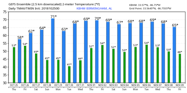
VERY COOL AND WET: Rain is moving into West Alabama early this morning in response to a surface low over Louisiana; today will be very wet and cool across the state with that rain becoming widespread by late morning and through the afternoon and tonight. Temperatures won’t get out of the 50s over the northern half of the state… the average high for Birmingham today is 73.
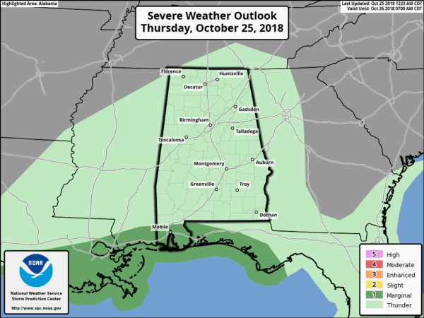
Some thunder is possible over far South Alabama; SPC has a “marginal risk” of severe thunderstorms defined for parts of Mobile and Baldwin counties.
TOMORROW AND THE WEEKEND: Rain will end early in the day tomorrow, but clouds will linger. The high tomorrow afternoon will be in the low 60s for most communities. For Saturday, the sky will be occasionally cloudy, but mostly dry. We will mention the risk of a few sprinkles pr light showers during the afternoon and evening hours in response to an upper trough over the region, but rain, if any, will be very light and very spotty. Saturday’s high will be close to 60 degrees as temperatures remain below average.
Sunday will be warmer with a partly sunny sky; a bit of light rain is possible Sunday evening over North Alabama thanks to a passing cold front. The high Sunday will be in the low 70s.
FOOTBALL WEATHER: For the high school games tomorrow night, the weather will be dry and cool… the sky will be cloudy with temperatures in the 50s for the games.
For Saturday’s Magic City Classic in Birmingham (Alabama State vs Alabama A&M at Legion Field; 2:30p CT kickoff), the sky will be occasionally cloudy, and there is just an outside chance of a few light showers during the second half of the game. Temperatures will be in the low 60s at kickoff, but they will fall into the upper 50s by the final whistle.
Alabama and Auburn have a bye week; UAB is on the road; they take on UTEP in El Paso, Texas Saturday evening (6:30p CT kickoff)… the sky will be clear with temperatures falling from the low 70s at kickoff to near 60 by the end of the game.
NEXT WEEK: Our weather will be dry Monday through Wednesday with sunny pleasant days and clear cool nights. Highs in the 60s Monday and Tuesday, then rising into the 70s on Wednesday (Halloween). A band of showers and thunderstorms is likely late Thursday or Thursday night with a cold front passing through; see the Weather Xtreme video for maps, graphics, and more details.
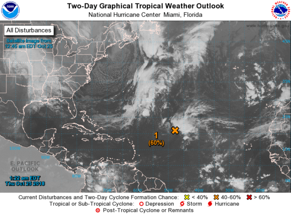
TROPICS: A tropical or sub-tropical storm will likely form in the Central Atlantic in coming days; it will get the name Oscar. It will drift westward, then turning northeast out to sea in response to a deep upper trough that will be over the eastern U.S. this weekend, so the system is no threat to North America. The rest of the Atlantic basin is quiet.
BEACH FORECAST: Click here to see the AlabamaWx Beach Forecast Center page.
WEATHER BRAINS: Don’t forget you can listen to our weekly 90 minute show anytime on your favorite podcast app. This is the show all about weather featuring many familiar voices, including our meteorologists here at ABC 33/40.
CONNECT: You can find me on all of the major social networks…
Facebook
Twitter
Instagram
Pinterest
Snapchat: spannwx
I have weather programs today at Berry Middle School in Hoover and Erwin Intermediate School in Center Point… look for the next Weather Xtreme video here by 4:00 this afternoon. Enjoy the day!
Category: Alabama's Weather, ALL POSTS, Weather Xtreme Videos
About the Author (Author Profile)
James Spann is one of the most recognized and trusted television meteorologists in the industry. He holds the AMS CCM designation and television seals from the AMS and NWA. He is a past winner of the Broadcast Meteorologist of the Year from both professional organizations.Subscribe
If you enjoyed this article, subscribe to receive more just like it.


