

A Look At The Severe Weather Threat Monday Night/Early Tuesday
A potent, dynamic weather system will bring the risk of severe thunderstorms to much of Alabama Monday night into Tuesday morning. A deep, negative tilt upper trough with strong wind fields will approach as a deepening surface low moves from the Southern Plains to the Great Lakes region. There has been good model consistency in the idea of an unstable, highly sheared atmosphere, and a significant threat is likely for parts of the Deep South and “Dixie Alley”.
We are still 60-72 hours away from the event, so there will always be some uncertainty, but this is what expect now…
PLACEMENT: SPC, on their “Day Three” severe weather outlook (which covers Monday and Monday night, through 6:00 a.m. CST Tuesday), has much of Northwest Alabama in an “enhanced risk” (level 3/5), with the standard “slight risk” (level 2/5) as far south as Heflin, Prattville, and Grove Hill. A “marginal risk” (level 1/5) extends down to Auburn, Troy, and Orange Beach.
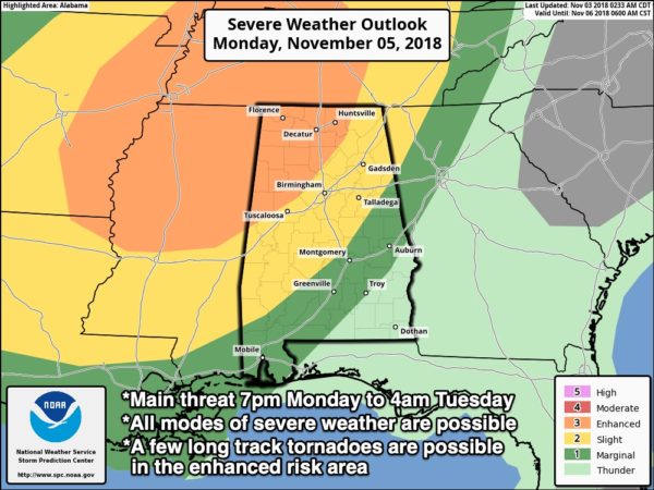
TIMING: The main window for severe thunderstorms will come from 7:00 p.m. Monday though 4:00 a.m. Tuesday. Storm will enter Northwest Alabama Monday night, and progress southeast overnight. Storms should be out of Alabama completely by early-morning Tuesday, so most of Election Day in our state should be dry with a clearing sky.
THREATS: Thunderstorms could produce hail, damaging winds, and a few tornadoes. In the “enhanced risk” (generally areas northwest of I-59), a few strong, long track tornadoes are possible. We do not expect any flooding issues since the storms will be moving along at a good clip; rain amounts around 1 inch are likely.

CALL TO ACTION: We are in our late fall tornado season in Alabama (November/December), so this weekend is a good time to be sure you are ready for what the atmosphere will deliver Monday night/Tuesday morning, and for the rest of year.
*Every Alabama home needs a NOAA Weather Radio, properly programmed, and with a good battery backup. You can find them at many local retail stores. And, you can program them… see this video from our meteorologist Charles Daniel for easy instructions. If you already have one, change the battery tonight when you set the clocks back one hour.
*Your second way of getting a warning is your smart phone. Be sure WEA (Wireless Emergency Alerts”) notifications are enabled… go to “settings”, “notifications”, and at the bottom your will see the options for “government alerts”. This has NOTHING to do with politics; be sure “emergency alerts” is enabled to receive tornado and flash flood warnings. Also have a good app designed for warnings on your phone, like this one.
*Get the ABC 33/40 mobile app on your phone so you can continue to watch our live coverage in your safe place.
Get the iOS version (for iPhones/iPads) here.
*Know where are you going. Your safe place is a small room (bathroom, closet, hallway) on the lowest floor, away from windows, and near the center of the home or building. If you live in a mobile home, you have to leave if you are in a tornado warning polygon. Know the location of a shelter that is available 24 hours, and be ready to get there quickly. Remember, a good part of this severe weather event early next week will be in the middle of the night.
*In your safe place, have helmets (bicycle or batting helmets are great) for everyone in the family, NOT just the kids. Also, everyone needs a portable air horn (if you need help first responders can hear them), and hard sole shoes (if you have to walk over a tornado debris field to get help). Portable chargers for your cell phones are also important so you can stay in touch and watch our severe weather coverage.
Will this be like April 27, 2011? Long time readers know I am not a fan of this question. Events like that are generational; they tend to happen every 40 years. If there is only one tornado in the state, and if it comes down your street, then that is YOUR April 27. We have to be ready for every severe weather threat.
Again we stress we are still a couple of days away from this event, and the forecast could change, so keep an eye on the blog for updates. And, we don’t share this information to panic anyone, or make you anxious, but this is information you need to make plans to keep you and your family safe. Hopefully, we get away with just a line of strong storms with little damage, but the setup does favor the potential for a dangerous tornado threat.
We will keep you posted…
Category: Alabama's Weather, Severe Weather
About the Author (Author Profile)
James Spann is one of the most recognized and trusted television meteorologists in the industry. He holds the AMS CCM designation and television seals from the AMS and NWA. He is a past winner of the Broadcast Meteorologist of the Year from both professional organizations.Subscribe
If you enjoyed this article, subscribe to receive more just like it.


