Rain Returns Later Today; Severe Storm Potential Continues For Late Monday Into Tuesday
SUNDAY: We’re starting off the day with clear skies, but we’ll have showers beginning to enter the western portion of the area around or just after the noon hour today, and we could see some shower activity in the Birmingham area starting around 4:00-6:00 pm. No thunder with today’s activity, but much of Central Alabama will have a decent chance of getting some rain, ranging from roughly 30-60%, with the higher chances being for the northern half of the area. Today’s highs will be in the mid-60s to the lower 70s throughout the area, with overnight lows in the 50s.
MONDAY: Throughout the day on Monday, we’ll continue to have mainly cloudy skies and a small chance of a few isolated to scattered showers and maybe a thunderstorm. Just remember that any activity that forms during the daylight hours will not be the main event, and unfortunately there looks like there will not be enough around to stabilize the atmosphere before the evening hours. Afternoon highs will be in the mid to the upper 70s for most in Central Alabama.
Forecast models continue to show a setup for a potentially significant severe weather event late on Monday and into the morning hours on Tuesday. With a strong jet setting up close by and an open-wave trough that will go negative tilt, we still see conditions coming together for all modes of severe weather… damaging winds in excess of 70 MPH, large hail, and some tornadoes. A few of those tornadoes have the potential to be significant, long-track tornadoes. The main window for severe storms in Central Alabama will be from roughly 10:00 pm Monday to 7:00 am Tuesday, with the chance that a few storms may linger around as late as 9:00 am for the extreme eastern locations in the area.
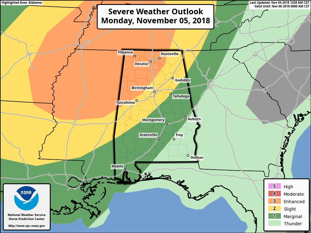
As of 2:00 am this morning, the Storm Prediction Center continues to have the northwest 1/4 of Alabama in an Enhanced Risk (level 3 of 5) of severe storms on Monday evening through Tuesday morning, with much of the rest of North and Central Alabama in a Slight Risk (level 2 of 5).
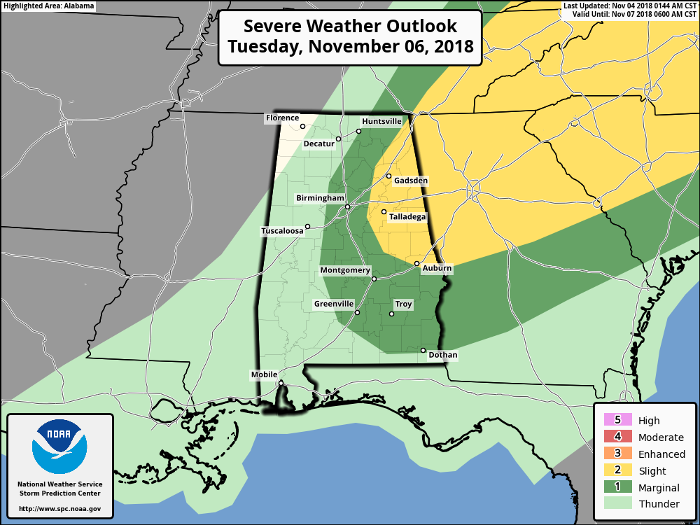
For Tuesday, the eastern half of the state is in a Marginal Risk with a good portion of the east-central and northeastern parts in a Slight Risk.
Taking a look at the severe parameters, we see that winds are still going to be backed out of the southeast and then quickly veering out of the south at 5,000 feet (or the 850mb level) and out of the west-southwest at 16,000 feet (or the 500mb level). We’ll have a good bit of surface-based instability available, with values in the 1,200-2,000 J/kg range, along with an ample amount of helicity. The Significant Tornado Parameter values on this latest run of the high-res NAM show values approaching 3.0 over parts of Central Alabama. All of this is showing us that we need to be prepared for all modes of severe weather. There is plenty of shear and instability for rotating updrafts, along with a jet of stronger winds at the 500mb level giving us the dynamic support for severe storms.
Once the threat moves out of the area on Tuesday afternoon, conditions will quickly begin to improve and skies will begin to clear out and mostly clear skies can be expected by Tuesday evening and into the overnight hours. Highs will top out in the lower 70s to the lower 80s from northwest to southeast, with overnight lows dropping into the mid-40s to the mid-50s.
WEDNESDAY: Models have changed from when I prepared the email forecast for the blog last night, as now Wednesday will feature a mix of sun and clouds with a chance of a few isolated to scattered showers. Afternoon highs in the upper 60s to the mid-70s.
THURSDAY & FRIDAY: An unsettled weather pattern will continue for Thursday and Friday as we’ll have a chance of showers and maybe a few thunderstorms, mainly through the afternoon hours on Thursday and coming to an end during the late morning to the early afternoon hours on Friday. The good news is that the activity should be out of here in enough time for the high school football games on Friday evening. Unfortunately, we will have to watch this event as a few stronger storms look to be possible at this time. Thursday’s highs will be in the mid-60s to the lower 70s, then turning cooler on Friday with highs in the upper 50s to the upper 60s.
NEXT WEEKEND: Saturday and Sunday look to be decent days at this point with a good bit of sunshine and highs in the 60s on both days.
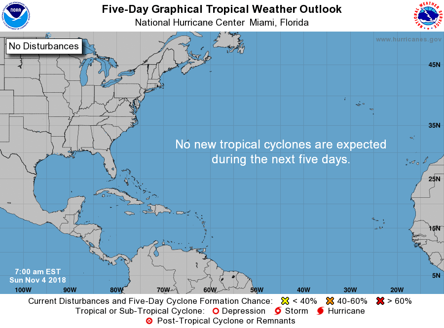
THE TROPICS: All is quiet for now and nothing is expected to form throughout the next 5 days.
Category: Alabama's Weather, ALL POSTS, Weather Xtreme Videos
About the Author (Author Profile)
Scott Martin is an operational meteorologist, professional graphic artist, musician, husband, and father. Not only is Scott a member of the National Weather Association, but he is also the Central Alabama Chapter of the NWA president. Scott is also the co-founder of Racecast Weather, which provides forecasts for many racing series across the USA. He also supplies forecasts for the BassMaster Elite Series events including the BassMaster Classic.Subscribe
If you enjoyed this article, subscribe to receive more just like it.


