

Rain At Times Through Friday; Colder Air For The Weekend
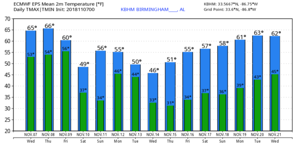
UNSETTLED WEATHER: Clouds return to Alabama today, and we expect rain to become fairly widespread across the state this afternoon and early tonight. The high this afternoon will be in the mid 60s for most communities. Clouds will stick around tomorrow and Friday, and we will mention periods of rain both days. We reach the 60s again tomorrow, but temperatures on Friday will hold in the cool 50s all day as cold air begins to roll in from the north. The sky begins to clear late Friday night.
THE ALABAMA WEEKEND: Sunshine returns to the state Saturday and Sunday, but temperatures will be well below average for mid-November. We expect a low between 30 and 35 degrees for most places across North/Central Alabama both mornings, but colder pockets will be in the 20s. The average date of the first freeze at Birmingham is November 9, so the freeze is pretty much on time.
FOOTBALL WEATHER: For the high school games Friday night, some lingering rain is possible during the first half, otherwise cloudy and cold with temperatures falling through the 40s.
Saturday, Alabama hosts Mississippi State Saturday afternoon at Bryant-Denny Stadium (2:30p CT kickoff)… the sky will be sunny a kickoff temperatures near 53 degrees… then falling into the 40s by the fourth quarter.
Auburn is at Georgia Saturday (6:00p CT kickoff)… the sky will be clear with temperatures falling from near 50 at kickoff, into the low 40s by the final whistle.
UAB will host Southern Miss at Legion Field Saturday evening (6:30p CT kickoff)… the sky will be clear with temperatures falling through the 40s.
NEXT WEEK: Clouds move in Sunday night, and we expect rain at times Monday and Tuesday ahead of the next push of cold air. It will be a cold rain; sure looks like we won’t get out of the 40s both days. And yes, the GFS hints at a few snow flakes over North Alabama Tuesday, but the low level thermal values really don’t support that idea. Sunshine returns Wednesday, but temperatures stay cold… we drop down into the 20s early Wednesday morning. The record low at Birmingham on November 14 is 24, set in 1986… we might be close. See the Weather Xtreme video for maps, graphics, and more details.
STORM SURVEY RESULTS: So far three tornadoes have been identified in Alabama from the storms late night and early yesterday morning… all were rated EF-1. One was in southern Lamar County near Millport… one was near Cloverdale in Lauderdale County, and the other was near Scottsboro in Jackson County. Many more were identified over North Louisiana, North Mississippi, and Middle Tennessee.
TROPICS: All remains quiet across the Atlantic basin; tropical storm formation is not expected this week.
BEACH FORECAST: Click here to see the AlabamaWx Beach Forecast Center page.
WEATHER BRAINS: Don’t forget you can listen to our weekly 90 minute show anytime on your favorite podcast app. This is the show all about weather featuring many familiar voices, including our meteorologists here at ABC 33/40.
CONNECT: You can find me on all of the major social networks…
Facebook
Twitter
Instagram
Pinterest
Snapchat: spannwx
I have weather programs today at Englewood Elementary in Tuscaloosa, and God’s House Kindergarten at Altadena Valley Presbyterian Church in Birmingham.. look for the next Weather Xtreme video here by 4:00 this afternoon. Enjoy the day!
Category: Alabama's Weather, ALL POSTS, Weather Xtreme Videos
About the Author (Author Profile)
James Spann is one of the most recognized and trusted television meteorologists in the industry. He holds the AMS CCM designation and television seals from the AMS and NWA. He is a past winner of the Broadcast Meteorologist of the Year from both professional organizations.Subscribe
If you enjoyed this article, subscribe to receive more just like it.


