Showers At Midday, Much Cooler Behind Cold Front; Freeze Warning Issued For Saturday Morning
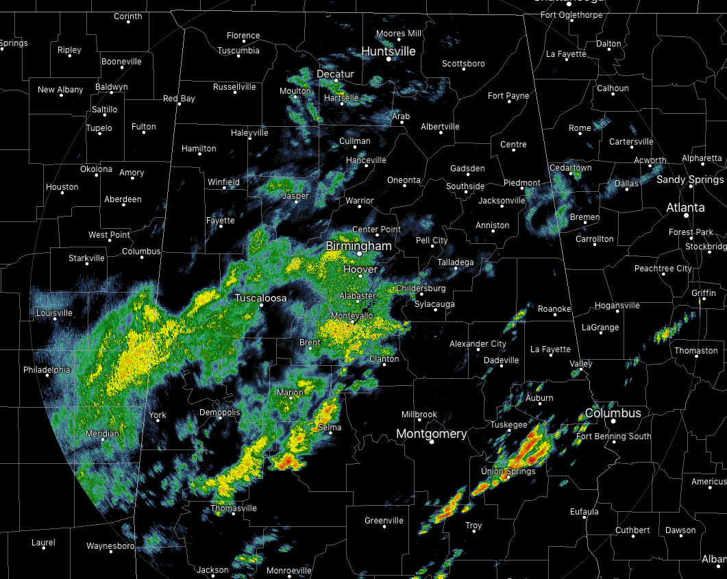
A good bit of scattered shower activity out there across Central Alabama just before 12:30 pm CST on this gray and damp Friday. The main coverage of shower activity is mainly over the west and southwestern parts of the area, but we do have a few heavier showers over the southeastern parts of Central Alabama as well. A few sprinkles or very light showers are also falling over the extreme eastern parts of the area and moving into Georgia as I type.
It’s cool across the northwestern parts of the area as readings are in the mid-40s to the lower 50s, a little warmer in the central third of the area in the mid-50s to the lower 60s, and warmer still in the southeast with upper 50s to the lower 70s. Troy is the warm spot at 75 degrees, still ahead of the cold front, while the cool spot is Haleyville at 46 degrees behind the cold front. Birmingham was at 54 degrees.
WEATHER FOR THE REST OF YOUR FRIDAY
While scattered showers are still likely across parts of Central Alabama for the rest of the day, the coverage will continue to slowly shift towards the south before diminishing in coverage just after sunset. Afternoon highs will only be in the lower 50s to the lower 70s across the area from the northwest to the southeast. While the northern half should be rain free by the kickoff of tonight’s high school football games, the southern half may have to put up with a few lingering showers through the first half. Temperatures at kickoff will be in the lower 40s to the upper 50s across the area, and falling into the upper 30s to the lower 50s by the 4th quarter. Overnight lows will be in the lower 30s to the lower 40s, with some of the colder valleys dipping into the 20s.
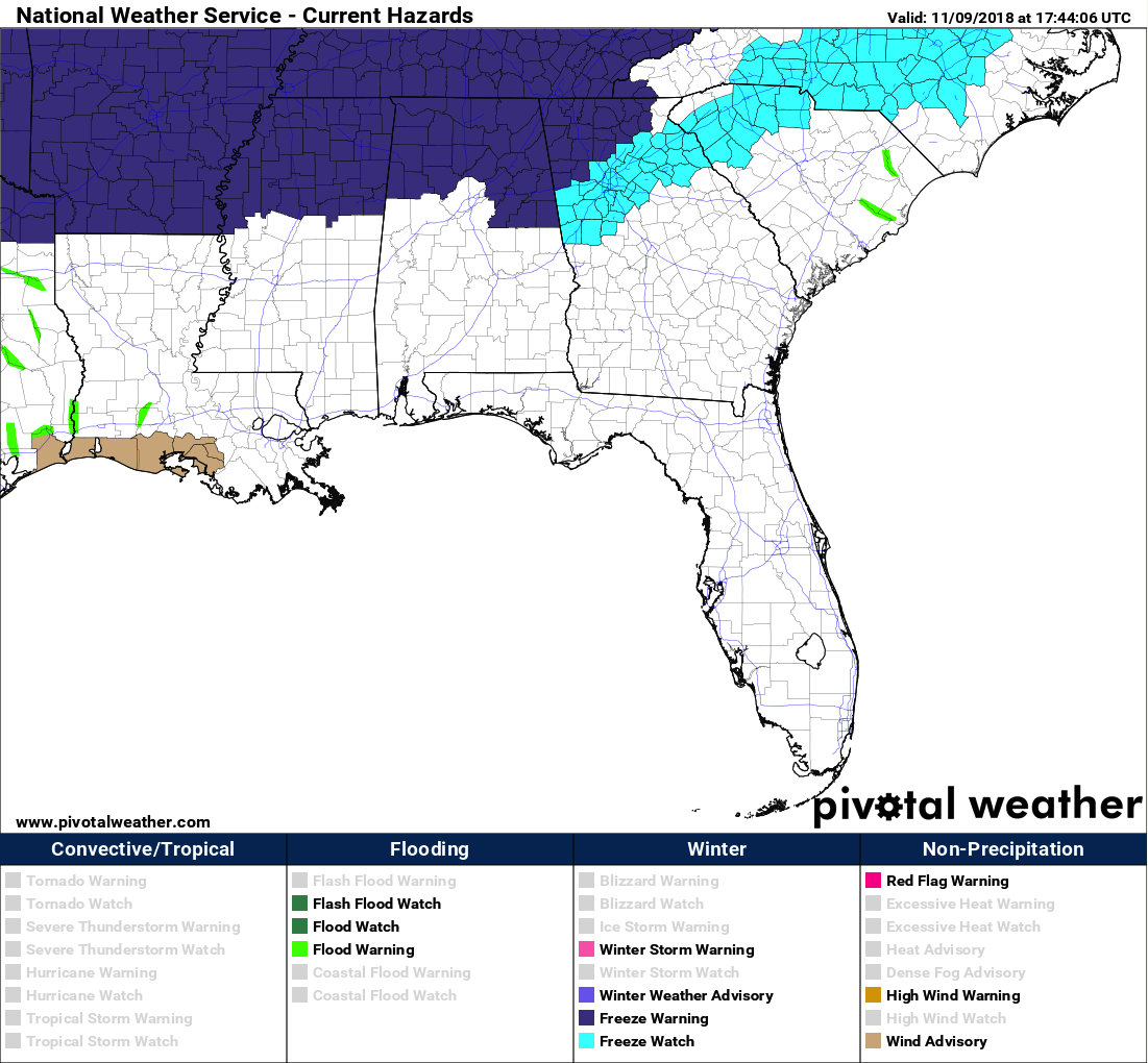
FREEZE WARNING IN EFFECT STARTING AT 2:00 AM CST SATURDAY
A colder airmass will move into the northern counties tonight. Thereafter, below freezing temperatures are expected in areas across the north Saturday morning.
NWS Huntsville has issued a Freeze Warning that will be in effect on early Saturday morning from 2:00 am to 8:00 am. North Alabama counties included in the Freeze Warning are Colbert, Cullman, DeKalb, Franklin, Jackson, Lauderdale, Lawrence, Limestone, Madison, Marshall, and Morgan.
NWS Birmingham has issued a Freeze Warning that will be in effect on early Saturday morning from 2:00 am to 8:00 am. Central Alabama counties included in the Freeze Warning are Blount, Calhoun, Cherokee, Clay, Cleburne, Etowah, Fayette, Lamar, Marion, Randolph, St. Clair, Talladega, Walker, and Winston.
WHILE SATURDAY MAY BE BEAUTIFUL, IT WILL BE A LITTLE BREEZY & VERY COOL
After a very chilly start to the morning, skies will remain clear with plenty of sunshine, but temperatures will remain very cool. Afternoon highs are expected to only reach the mid-40s to the upper 50s throughout the area from northwest to southeast. Winds out of the north will make it feel even cooler as they will be averaging in the 10-15 MPH range. Another freeze warning may be likely for the overnight once again as skies will be clear throughout much of the late night and into the pre-dawn hours. Lows will be dipping down into the upper 20s to the upper 30s.
THE TROPICS
All is quiet across the Caribbean Sea, the Gulf of Mexico, and the Atlantic Ocean, and no new tropical cyclones are expected to form throughout the next five days. The end of the season is approaching quickly, November 30th. Let’s hope it stays quiet.
Category: Alabama's Weather, ALL POSTS
About the Author (Author Profile)
Scott Martin is an operational meteorologist, professional graphic artist, musician, husband, and father. Not only is Scott a member of the National Weather Association, but he is also the Central Alabama Chapter of the NWA president. Scott is also the co-founder of Racecast Weather, which provides forecasts for many racing series across the USA. He also supplies forecasts for the BassMaster Elite Series events including the BassMaster Classic.Subscribe
If you enjoyed this article, subscribe to receive more just like it.


