Soaking, Cold Rain Today
WET IS THE WORD: Just about every square inch of Alabama should see a soaking rain during the first half of this week. A broad surface low will move along the Gulf Coast region today; rain is widespread this morning, and rain continues tonight into at least part of the day tomorrow. The air just off the coast is unstable, and as that lifts into far South Alabama a few severe storms are possible there today. A tornado watch is in effect until 12 noon for Mobile and Baldwin counties…
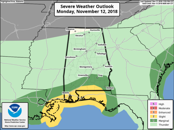
We also note a flash flood watch is in effect for far South Alabama, but we can’t rule out a few isolated flooding issues over the northern counties of the state as well. Rain amounts over the next 36 hours will be in the 2-4 inch range.
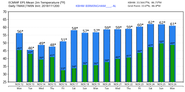
It will be a cold rain for most; temperatures today will hover in the 45-52 degree range, although far South Alabama could see 60s this afternoon.
MID-WEEK: Rain will taper off during the midday hours tomorrow, but clouds linger through the day. The high will be only in the mid 40s over North Alabama, with 50s for the southern counties. Part of the upper trough responsible for the rain today, however, will hang back, and as that final segment lifts out we will deal with more rain tomorrow night and Wednesday. And, temperatures will stay cold… they hover in the 40-46 degree range Wednesday, a good 20 degrees below average for mid-November in Alabama.
THURSDAY/FRIDAY: Rain will end early Thursday, but clouds linger much of the day with a high in the upper 40s. Then, finally, sunshine returns in full force Friday with a high in the upper 50s. We note Friday morning will be cold with a low between 28 and 32 degrees for most places.
THE ALABAMA WEEKEND: Saturday and Sunday will be dry with sunny cool days and fair cold nights. Highs between 58 and 62, lows between 35 and 40.
NEXT WEEK: For now the first half of Thanksgiving week looks dry and cool with highs mostly in the 50s and lows in the 30s… see the Weather Xtreme video for maps, graphics, and more details.
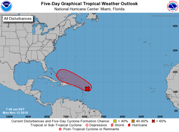
TROPICS: There is a high chance a tropical depression or storm will form in the Atlantic east of the Bahamas in 3-5 days, but most likely this recurves out into the Atlantic and will not be a threat to the U.S. Atlantic coast.
BEACH FORECAST: Click here to see the AlabamaWx Beach Forecast Center page.
WEATHER BRAINS: Don’t forget you can listen to our weekly 90 minute show anytime on your favorite podcast app. This is the show all about weather featuring many familiar voices, including our meteorologists here at ABC 33/40.
CONNECT: You can find me on all of the major social networks…
Facebook
Twitter
Instagram
Pinterest
Snapchat: spannwx
Look for the next Weather Xtreme video here by 4:00 this afternoon… enjoy the day!
Category: Alabama's Weather, ALL POSTS, Weather Xtreme Videos
About the Author (Author Profile)
James Spann is one of the most recognized and trusted television meteorologists in the industry. He holds the AMS CCM designation and television seals from the AMS and NWA. He is a past winner of the Broadcast Meteorologist of the Year from both professional organizations.Subscribe
If you enjoyed this article, subscribe to receive more just like it.


