Breezy, Cold, Dry Day For Alabama
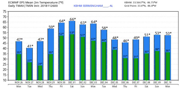
WINDY AND COLD: A tight pressure gradient following a cold front brought windy conditions to the northern half of Alabama overnight; winds gusted to 25 mph in many spots. These winds will usher in much colder air; despite a good supply of sunshine today temperatures won’t get out of the 40s over North Alabama, and South Alabama will hold in the 50s.
TOMORROW THROUGH FRIDAY: We will see some of the coldest temperatures so far this season early tomorrow and Wednesday morning. Lows will be well down in the 20s, and some of the colder pockets across North Alabama will visit the teens for the first time. Look for sunshine in full supply tomorrow and Wednesday; the high tomorrow will be in the 45-49 degree range over North/Central Alabama, and close to 50 on Wednesday. Thursday will be dry and warmer with a high close to 60.
Moisture levels rise Friday, and a few scattered showers are possible with a high in the mid 60s.
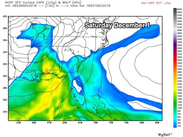
STRONG STORMS POSSIBLE SATURDAY: A rather vigorous weather system will bring strong thunderstorms to Alabama Saturday. A deep surface low will be near St. Louis, and unstable air will surge northward into the state from the Gulf of Mexico. Initial forecast wind profiles suggest that severe storms are very possible across the state, but it is too early to determine the timing, placement, and the magnitude of the threat. Just something to watch for now. Rain amounts Saturday of around one inch are likely, and we will see a high near 70 degrees.
SUNDAY THROUGH EARLY NEXT WEEK: Sunday and Monday will be dry and mild with a high in the 60s, but another dynamic system will bring a chance of more strong thunderstorms by Tuesday of next week. Then, more cold air will invade the Deep South for the latter half of the week. See the Weather Xtreme video for maps, graphics, and more details.
BIG SNOW STORM: Blizzard conditions brought travel to a crawl from Kansas City to Chicago yesterday and last night. The snow total in Kansas City was 5.8″… a record for the date, and the second snowiest November day on record. Wind gusted to 55 mph at Kansas City International Airport during the snow.
BEACH FORECAST: Click here to see the AlabamaWx Beach Forecast Center page.
WEATHER BRAINS: Don’t forget you can listen to our weekly 90 minute show anytime on your favorite podcast app. This is the show all about weather featuring many familiar voices, including our meteorologists here at ABC 33/40.
CONNECT: You can find me on all of the major social networks…
Facebook
Twitter
Instagram
Pinterest
Snapchat: spannwx
Look for the next Weather Xtreme video here by 4:00 this afternoon… enjoy the day!
Category: Alabama's Weather, ALL POSTS, Weather Xtreme Videos
About the Author (Author Profile)
James Spann is one of the most recognized and trusted television meteorologists in the industry. He holds the AMS CCM designation and television seals from the AMS and NWA. He is a past winner of the Broadcast Meteorologist of the Year from both professional organizations.Subscribe
If you enjoyed this article, subscribe to receive more just like it.


