

Warmer Days Ahead; Strong Storms Saturday
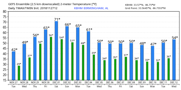
COLD NOVEMBER DAY: Temperatures across North/Central Alabama are 20-25 degrees below average for November 27… generally in the 37-44 degree range. The sky is sunny, and a brisk north wind is making it feel colder. Another significant freeze is ahead tonight; most communities will drop into the 20-25 degree range early tomorrow with a clear sky and light wind, but some of the colder pockets will slip into the upper teens.
Tomorrow will be sunny with light wind, and a warming trend begins… we rise to near 50 degrees tomorrow afternoon.
THURSDAY/FRIDAY: Clouds will increase Thursday, and a few widely scattered showers could break out late in the day over North Alabama. Then, Friday will be a mostly cloudy day with a chance of scattered showers over the northern half of the state. The high Thursday will be in the upper 50s, followed by mid 60s Friday.
To the west, strong to severe storms will likely fire up Friday in a broad zone from Shreveport to Memphis as a vigorous storm system approaches. SPC has outlined a risk of severe thunderstorms for this area in their “Day 4” outlook…
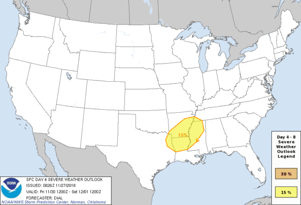
STRONG STORMS SATURDAY: A deep surface low will be over Missouri Saturday, supported by a strong upper trough. Moist, unstable air will surge into Alabama from the south, and with the approach of a cold front strong thunderstorms are likely. Storms could possibly be severe, but it remains to be seen if parameters will come together for this. Much will depend on timing, if the storms arrive early in the day, when the air is more stable, the overall severe threat is lower. Afternoon storms could combine with higher instability levels for a more substantial threat.
Bottom line is that is still too early to be specific about the timing, placement, and magnitude of the severe weather threat Saturday. But rain is certainly likely for part of the day, and the rain could be heavy at times. The high Saturday will be around 70 degrees.
Saturday night and Sunday look dry… in fact Sunday should be a nice day with a partly to mostly sunny sky along with a high near 70 degrees.
NEXT WEEK: Another dynamic storm system will bring another round of rain and strong thunderstorms to Alabama late Monday and Monday night; this one will also need to monitored for severe potential as we get closer. The rain will end early Tuesday, and much colder air arrives for the latter half of the week (Wednesday through Friday). See the Weather Xtreme video for maps, graphics, and more details.
TROPICS: The Atlantic basin remains quiet, and the 2018 hurricane season ends Friday.
BEACH FORECAST: Click here to see the AlabamaWx Beach Forecast Center page.
WEATHER BRAINS: Don’t forget you can listen to our weekly 90 minute show anytime on your favorite podcast app. This is the show all about weather featuring many familiar voices, including our meteorologists here at ABC 33/40.
CONNECT: You can find me on all of the major social networks…
Facebook
Twitter
Instagram
Pinterest
Snapchat: spannwx
I had a great time today visiting with the students at Vernon Intermediate School in Lamar County… be looking for them on the Pepsi KIDCAM today at 5:00 on ABC 33/40 News! The next Weather Xtreme video will be posted here by 7:00 a.m. tomorrow…
Category: Alabama's Weather, ALL POSTS, Weather Xtreme Videos
About the Author (Author Profile)
James Spann is one of the most recognized and trusted television meteorologists in the industry. He holds the AMS CCM designation and television seals from the AMS and NWA. He is a past winner of the Broadcast Meteorologist of the Year from both professional organizations.Subscribe
If you enjoyed this article, subscribe to receive more just like it.


