

Warming Trend In Coming Days; Rain And Storms Saturday
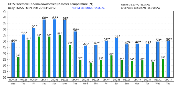
FEELS BETTER THIS AFTERNOON: After lows in the 18-24 degree range for most places this morning, we have warmed nicely today, with most communities in the low 50s at mid-afternoon. Tonight will be fair and not as cold as recent nights… we drop into the 30s early tomorrow morning. Some of the colder spots will see a freeze, but most places will be in the mid to upper 30s.
Clouds increase tomorrow, but we will mention only a small risk of an afternoon shower, mostly over the northwest part of the state. The warming trend continues as we rise into the 57-60 degree range.
FRIDAY AND THE WEEKEND: Friday will be a cloudy and mild day with a chance of showers for the northern half of the state; the high Friday afternoon will be in the mid 60s. To the west, severe storms will break out Friday afternoon and Friday night, and SPC has the standard “slight risk” (level 2/5) of severe storms defined for much of Arkansas and some of the adjacent states. A “marginal risk” (level 1/5) does extend into Southwest Alabama in this “Day 3” outlook, which runs through 6:00 a.m. Saturday.
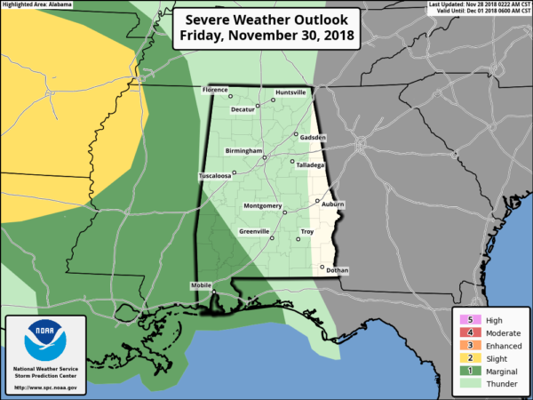
Some of the storms that enter West and Southwest Alabama early Saturday could be strong, possibly severe, ahead of a dynamic weather system.
Saturday will be a wet and stormy day for the state. There are many outdoor events planned, and it is impossible to give specific start/stop times for the rain, but wet weather is likely in the broad 12 hour window from 6:00 a.m. to 6:00 p.m. It won’t rain the entire 12 hours, but periods of rain and a few strong thunderstorms are likely. We will have to watch storms for severe potential… at the moment it looks like key parameters could be a little out of phase for a big severe weather issue, but we do note the morning run of the NAM (North American Mesoscale) model shows elevated STP (Significant Tornado Parameter) value over South Alabama during the day Saturday. Rain amounts of around one inch are likely, and the high will be in the 67-70 degree range.
Saturday night and Sunday will be dry; in fact Sunday looks like a very nice day with a partly sunny sky and a high in the low 70s.
FOOTBALL WEATHER: Saturday’s SEC title game between Alabama and Georgia (3:00p CT kickoff) will be played in Mercedes-Benz Stadium in Atlanta (in the dome); for those walking to the game rain and thunderstorms are likely in Atlanta with temperatures in the 60s. The rain will end Saturday night.
UAB will take on Middle Tennessee State in the C-USA Championship game in Murfreesboro, Tennessee Saturday (12:30p CT kickoff)… rain and thunderstorms are likely during the game with temperatures around 60 degrees. The rain could be heavy at times.
Jacksonville State travels to Orono Maine to take on the Maine Black Bears Saturday (11a CT kickoff)… the sky will be mostly sunny with 29 degrees at kickoff, rising into the mid 30s by the fourth quarter.
NEXT WEEK: The next wave will bring more rain to the state Monday and Monday night; a few thunderstorms are possible, but for now this doesn’t look like a major severe weather threat. Rain ends early Tuesday followed by falling temperatures, and the latter half of the week will be dry and cold. See the Weather Xtreme video for maps, graphics, and more details.
HURRICANE SEASON ENDS FRIDAY: The 2018 Atlantic hurricane season officially concludes Friday, and will be remembered most for hurricanes Florence and Michael, which caused significant damage in the southeastern U.S. In total, the season produced 15 named storms, including eight hurricanes of which two were “major” (Category 3, 4 or 5). An average season has 12 named storms, six hurricanes, and three major hurricanes.
BEACH FORECAST: Click here to see the AlabamaWx Beach Forecast Center page.
WEATHER BRAINS: Don’t forget you can listen to our weekly 90 minute show anytime on your favorite podcast app. This is the show all about weather featuring many familiar voices, including our meteorologists here at ABC 33/40.
CONNECT: You can find me on all of the major social networks…
Facebook
Twitter
Instagram
Pinterest
Snapchat: spannwx
Look for the next Weather Xtreme video here by 7:00 a.m. tomorrow…
Category: Alabama's Weather, ALL POSTS, Weather Xtreme Videos
About the Author (Author Profile)
James Spann is one of the most recognized and trusted television meteorologists in the industry. He holds the AMS CCM designation and television seals from the AMS and NWA. He is a past winner of the Broadcast Meteorologist of the Year from both professional organizations.Subscribe
If you enjoyed this article, subscribe to receive more just like it.


