Two Rounds Of Strong Storms On Saturday?
SEVERE STORM THREAT ON SATURDAY
As we get ready for a big weekend across the southeastern United States with big high school and college football games, along with many parades and holiday festivities, we have a possible severe weather situation developing for Saturday.
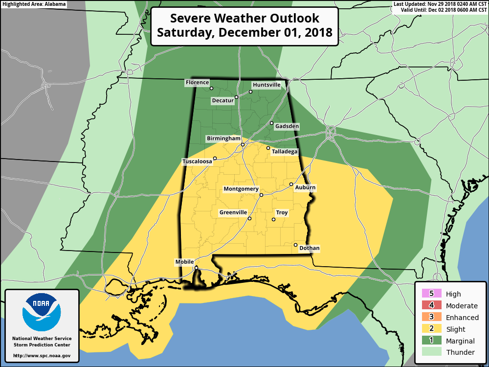
As you can see in the Severe Weather Outlook graphic from the Storm Prediction Center, a very large chunk of Central Alabama has been defined in a Slight Risk for severe storms throughout the day on Saturday, with the northern parts of the area in a Marginal Risk.
Some strong storms could move into the southwestern parts of the area as early as 12:00 am Saturday and persist until around 12:00 pm. Main threats with these will be from some gusty winds, small hail, and cloud-to-ground lightning.
There is a conditional chance that we could have a second round of strong to severe storms during the afternoon and early evening hours (12:00 pm – 6:00 pm). If this occurs, we could have damaging thunderstorm wind gusts and the possibility of a tornado or two. Here are the details for the second half of the day painted by the latest run of the high-resolution NAM…
________________________________________
SHEAR VALUES
This crossover image from the 00z NAM-3K is valid as of 6:00 pm Saturday evening and it shows winds at the surface out of the south and south-southeast across the area at 5-10 knots, then veering quickly out of the southwest at 35-40 knots at roughly 5,000 feet. Then winds veer a little more out of the west-southwest around the 18,000 feet level at 70-90 knots.
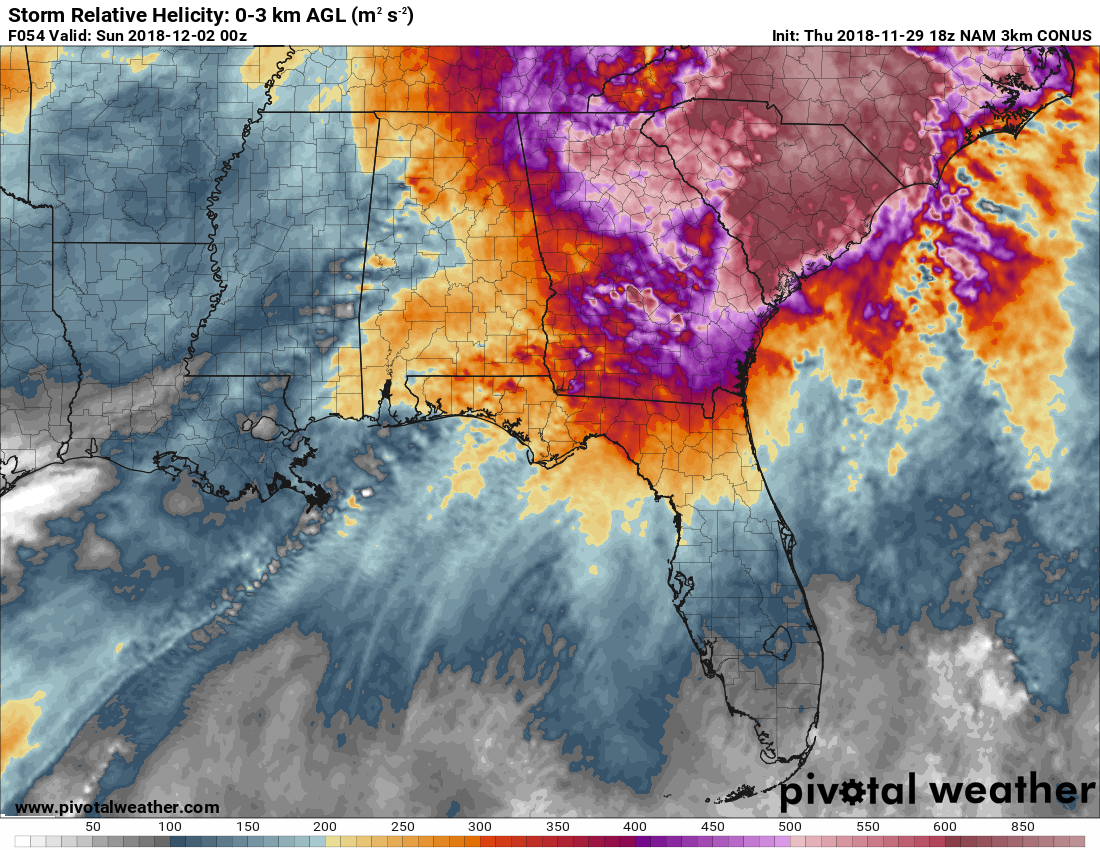
Storm relative helicity values (valid 6:00 pm Saturday) from the surface up to 3,000 feet are modeled to be in the 150-400 m2s2 range. Usually, numbers of 250 m2s2 and higher suggest an increased threat of tornadoes.
Both of these graphics show that the potential will be there for rotating updrafts.
________________________________________
SIGNIFICANT TORNADO PARAMETER (STP)
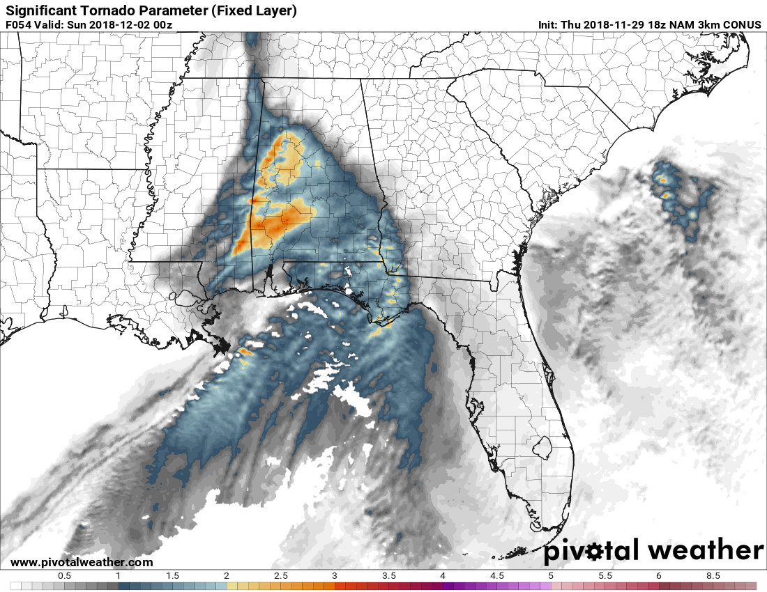
This image from the same 00z NAM-3K run valid at 6:00 pm Saturday shows that the significant tornado parameter values are modeled to be in the 1.0-3.0 range across a good bit of Central Alabama.
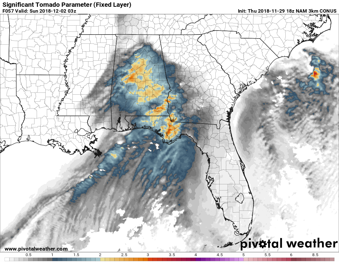
Just three hours later, those values have shifted eastward with the higher values of 2.0-3.0 over the central parts of the area, including Jefferson, Shelby, Tuscaloosa, and Bibb counties.
These images show us that possible supercell thunderstorms have the potential significant tornado development (EF2 or stronger). Any number of 1.0 and above shows that potential, while values less than 1.0 are usually associated with non-tornadic supercells.
________________________________________
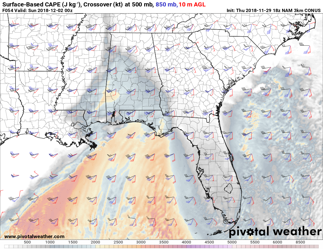
SURFACE-BASED INSTABILITY (CAPE)
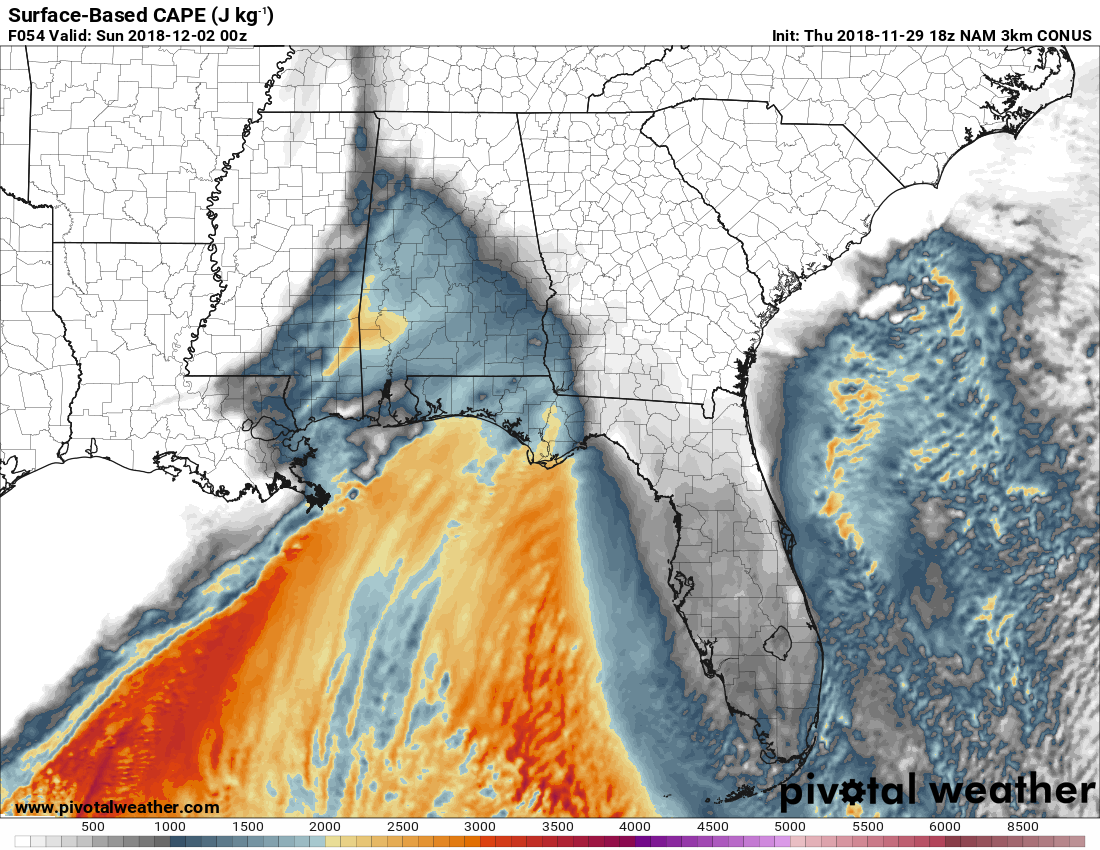
Also from the 00z NAM-3K run valid at 6:00 pm, this image shows the amount of potential energy available for convective development. During the fall severe weather season, it doesn’t take much CAPE to have severe weather as we usually have enough shear in place. At this point, we’ll have the potential to have instability values ranging from 1,200-2,000 J/kg. That is plenty of instability to support convective development.
________________________________________
THERE IS STILL SOME UNCERTAINTY IN THE FORECAST
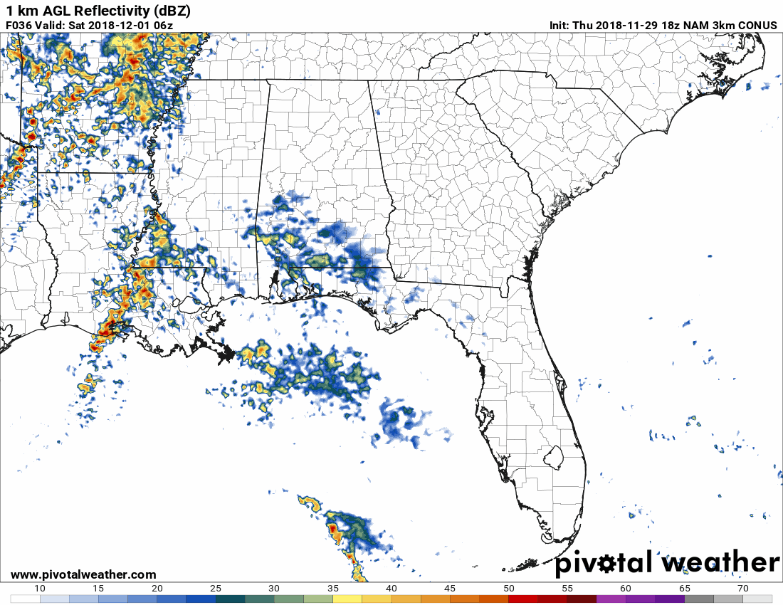
There appears to be some convective development that will take place in the far southern parts of the state and along the gulf coast that could limit the amount of instability up into the area. If that occurs, there could be a decent dry slot that forms that will limit the development of thunderstorms during the afternoon and evening hours. We also have to take into account the low sun angle and how quickly we now lose the daytime heating.
Also as you can see with the animation, we’ll have a good bit of shower and thunderstorm activity move across the area during the morning hours. How significant of an impact will that make in stabilizing the atmosphere over the area?
While there will be a low-level jet over the area, especially over the northwestern parts of Central Alabama, that will move out well before noon… BUT… another low-level jet is expected to move in over the western and northwestern counties during the late afternoon and progress across the area through the early evening.
This will give us the possibility of some strong storms during the morning until noon, then we’ll have the possibility of more cellular thunderstorms developing from early afternoon through early evening. If that occurs, we’ll have the threat of damaging winds, some small hail, and one or two tornadoes.
We’ll have a better picture of what to expect within the next several hours. Stay up-to-date with the AlabamaWx Weather Blog.
Category: Alabama's Weather, ALL POSTS
About the Author (Author Profile)
Scott Martin is an operational meteorologist, professional graphic artist, musician, husband, and father. Not only is Scott a member of the National Weather Association, but he is also the Central Alabama Chapter of the NWA president. Scott is also the co-founder of Racecast Weather, which provides forecasts for many racing series across the USA. He also supplies forecasts for the BassMaster Elite Series events including the BassMaster Classic.Subscribe
If you enjoyed this article, subscribe to receive more just like it.


