Warming Trend Continues; Storms Saturday Morning
WARMING UP: Temperatures are in the 60s over much of West and South Alabama this afternoon as the warming trend continues, but cool air is still over Northeast Alabama where some places have struggled to get out of the 40s. The sky is mostly cloudy, and there is nothing really signifiant on radar at mid-afternoon. Tonight will be mostly cloudy with just a few isolated showers; lows early tomorrow will be in the 50s as warm air advection continues.
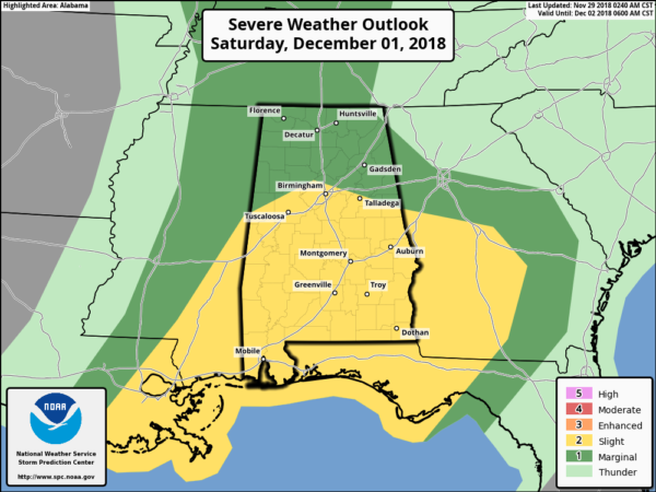
TOMORROW/SATURDAY: A vigorous storm system will bring the threat of severe storms to areas west of Alabama tomorrow; there is an “enhanced risk” (level 3/5) defined for much of Arkansas and some of the adjacent states. Here in Alabama, occasional showers are likely tomorrow with a cloudy sky. The high will be in the upper 60s.
Heavier storms will move into Alabama late tomorrow night, and it now looks like the first window for strong thunderstorms in our state will come from 12:00 midnight tomorrow night until 12:00 noon Saturday.
It still looks like this system will be a bit out of phase; good thermodynamics will become established Saturday afternoon with rising instability values, but by then the main dynamic support will have lifted away to the northeast.
The key question involves redevelopment of storms during the afternoon hours when the instability is highest. Most mesoscale models for now don’t show any development, but it certainly can’t be ruled out. And, if storms can form Saturday afternoon, they could become severe with potential for some hail, strong winds, and even an isolated tornado. So, the “second window” for strong, possibly severe storms, will come from 12 noon until 6:00 p.m… but understand this is a conditional risk.
SPC has the standard “slight risk” (level 2/5) defined from Birmingham south Saturday, with a “marginal risk” (level 1/5) for areas north of Birmingham.
We always have to watch these cool season systems like this closely for surprises.
Most of the new model guidance suggests that most of the showers and storms will be over South Alabama by Saturday evening, with dry conditions for the northern half of the state. The day will be mild with a high around 70 degrees… and Saturday night will be dry statewide.
SUNDAY: Morning clouds will give way to a partly sunny afternoon, and the high will be up in the low 70s. Any showers should be confined to South Alabama, and even there they should be widely spaced. A cold front could bring some rain to the state late Sunday night or early Monday morning, but global models have greatly backed off on the idea of significant rain with this feature.
FOOTBALL WEATHER: Saturday’s SEC title game between Alabama and Georgia (3:00p CT kickoff) will be played in Mercedes-Benz Stadium in Atlanta (in the dome); for those walking to the game showers and thunderstorms are likely in Atlanta with temperatures in the 60s. The rain will end Saturday evening.
UAB will take on Middle Tennessee State in the C-USA Championship game in Murfreesboro, Tennessee Saturday (12:30p CT kickoff)… the good news is that it now looks like most of the rain will be over by kickoff; just an outside risk of a lingering shower during the first half. Otherwise a mostly cloudy afternoon with temperatures in the 60s.
Jacksonville State travels to Orono Maine to take on the Maine Black Bears Saturday (11a CT kickoff)… the sky will be partly sunny with 29 degrees at kickoff, rising into the mid 30s by the fourth quarter.
NEXT WEEK: Monday will feature a clearing sky, a stiff north wind, and potential falling temperatures. Then, the weather looks cold and dry for the rest of the week… a good chance we won’t get out of the 40s Tuesday through Thursday. See the Weather Xtreme video for maps, graphics, and more details.
BEACH FORECAST: Click here to see the AlabamaWx Beach Forecast Center page.
WEATHER BRAINS: Don’t forget you can listen to our weekly 90 minute show anytime on your favorite podcast app. This is the show all about weather featuring many familiar voices, including our meteorologists here at ABC 33/40.
CONNECT: You can find me on all of the major social networks…
Facebook
Twitter
Instagram
Pinterest
Snapchat: spannwx
I had a great time today visiting with students at Huffman Middle School and Bagley Elementary School… be looking for them on the Pepsi KIDCAM today at 5:00 and 6:00 on ABC 33/40 News! The next Weather Xtreme video will be posted here by 7:00 a.m. tomorrow…
Category: Alabama's Weather, ALL POSTS, Weather Xtreme Videos
About the Author (Author Profile)
James Spann is one of the most recognized and trusted television meteorologists in the industry. He holds the AMS CCM designation and television seals from the AMS and NWA. He is a past winner of the Broadcast Meteorologist of the Year from both professional organizations.Subscribe
If you enjoyed this article, subscribe to receive more just like it.


