

Trending Colder; Rain Returns Over The Weekend
RADAR CHECK: We have a few showers on radar early this morning in a zone from near Greenville to Opelika… these will end soon and most of the state will be dry today. With a partly sunny sky we project a high in the 57-61 degree range for the northern half of the state, with 60s for South Alabama.
TRENDING COLDER: Tomorrow will be mostly sunny, but the high will be only in the 40s over North Alabama, with 50s for the southern counties of the state. Mornings for the rest of the week will be cold with 20s and 30s; the coldest will most likely be early Wednesday when the sky will be clear and the wind near calm. The sky stays mostly sunny Wednesday and Thursday with highs in the 50s; clouds will begin to increase Friday afternoon ahead of a storm system to the west. Friday’s high will be in the 55-60 degree range.
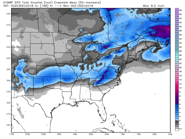
COLD, WET WEEKEND: A surface low will form over the northwest Gulf of Mexico Friday night, and as it moves eastward it will spread a cold rain across much of the southern U.S. For Alabama the day Saturday looks cold and wet with widespread rain; temperatures over North Alabama will hold in the 40s all day, with 50s to the south. There is potential for snow over parts of Arkansas and Tennessee where the air is colder.
As the low moves east of the region Sunday, rain will taper off during the morning, and colder air will be pulled southward. This could open for door for a light “wintry mix” over far North Alabama, but there is no skill in forecasting placement or impact six days in advance. Just something to watch for now; keep an eye for any potential forecast changes as we get closer to the weekend.
For snow fans, output from the European ensemble suggests a nice band of snow across parts of Oklahoma, Arkansas, Tennessee and Kentucky with this system…
NEXT WEEK: For now the weather for much of the week looks dry with seasonal temperatures; see the Weather Xtreme video for maps, graphics, and more details.
ON THIS DATE IN 1983: As the Iron Bowl was being played at Legion Field in Birmingham, NWS radar at Centreville showed a well defined hook echo heading directly toward the stadium. Legion Field Public Address announcer Simpson Pepper read the warning over the loudspeakers but the game was not stopped. By ten minutes to go in the game, the rain was coming down in torrents as Auburn tried to control the ball and win the game in the horrible conditions as they clung to a 23-20 lead. The rain began to fall so heavily that you could barely see the field on the cameras.
Fortunately, the storm did not produce a tornado in western Birmingham, or the results would have been catastrophic. But later, the same storm dropped an F3 tornado that heavily damaged the Winn Dixie store at Sky City in Oxford, killing two people. A total of seven tornadoes touched down across the state that afternoon and evening. Auburn went on to win the game 23-20.
BEACH FORECAST: Click here to see the AlabamaWx Beach Forecast Center page.
WEATHER BRAINS: Don’t forget you can listen to our weekly 90 minute show anytime on your favorite podcast app. This is the show all about weather featuring many familiar voices, including our meteorologists here at ABC 33/40.
CONNECT: You can find me on all of the major social networks…
Facebook
Twitter
Instagram
Pinterest
Snapchat: spannwx
I have a weather program this morning at Gwin Elementary in Hoover… look for the next Weather Xtreme video here by 4:00 this afternoon. Enjoy the day!
Category: Alabama's Weather, ALL POSTS, Weather Xtreme Videos
About the Author (Author Profile)
James Spann is one of the most recognized and trusted television meteorologists in the industry. He holds the AMS CCM designation and television seals from the AMS and NWA. He is a past winner of the Broadcast Meteorologist of the Year from both professional organizations.Subscribe
If you enjoyed this article, subscribe to receive more just like it.


